Showing posts with label north cascades. Show all posts

Saturday, July 18, 2015

Mount Pugh Hike

Hike Notes

Length: 10.4 miles roundtrip (turn around after Stujack Pass, before exposure point)
Duration: About 6 hours, 9:00 am - 3:15 pm with a break for lunch
Elevation: Starting 1,883 feet,  max at 6,246 feet.
Location: North Cascades, Mount Loop Highway

Overview

I'll confess right up front: we did not reach the peak. Because of pending dinner plans back in Seattle, we turned around between Stujack pass (5,500 feet) and the the exposure point -- as one experienced climber we talked to called it.  All in all, getting to Stujack Pass and beyond was still quite a bit of work. The Washington Trails Association page for the this hike says 11.0 roundtrip to the peak. We were on the high side of mileage because of a detour around the right side of Lake Metan (nothing to really see there). The trail up goes around the left side of the lake.

The first part of the hike has the usual plant suspects of lower elevation forested areas: Mahonia, Maianthemum, Linnaea, and Tiarella. We saw Corallorhiza on the way out and Goodyera coming into the bloom, and we saw a few Listera specimens. 

At a boulder field beyond Lake Metan, it's all sun and high meadow plants like Achillea, Artemisia, Agoseris, Aquilegia, Castilleja, Campanula, Chamerion, and Luina to name a few. The abundance of flowers gives you lots of photo opportunities and opportunity to rest on this steep section before Stujack Pass. Of note is that while relatively small as meadows go, this one had a large number of butterflies, and they did not seem as frightened by our presence as butterflies on our other hikes.

Plant List

Photos in next section.

[Asparagaceae] Asparagus Family
  Maianthemum racemosum - Feathery False Lily-of-the-Valley

[Asteraceae] Aster Family
  Agoseris aurantiaca - Orange Agoseris
  Anaphalis margaritacea - Western Pearly Everlasting
  Artemisia ludoviciana - White Sagebrush
  Cirsium edule - Edible Thistle
  Luina hypoleuca - Little-Leaf Silverback

[Campanulaceae] Harebell Family
  Campanula rotundifolia - Bluebell Bellflower

[Caryophyllaceae] Pink Family
  Silene latifolia - Bladder Campion

[Melanthiaceae] False-Hellebore Family
  Veratrum viride - Green False Hellebore

[Orchidaceae] Orchid Family
  Goodyera oblongifolia - Western Rattlesnake Plantain
  Platanthera orbiculata - Lesser Round-Leaved Orchid

[Polygonaceae] Buckwheat Family
Bistorta bistoroides - American/Western Bistort

[Rosaceae] Rose Family
  Rubus parviflorus – Thimbleberry


Open, Mountain High Plants

Left: Agoseris aurantiaca - Orange Agoseris; Right: Artemisia ludoviciana - White Sagebrush
Agoseris aurantiaca - Orange AgoserisArtemisia ludoviciana - White Sagebrush

Left: Grasshopper on Indian Paintbrush; Center: Bistort; Right: Luina and Anaphalis
Grasshopper on Indian PaintbrushBistortLuina and Anaphalis

Left: Campanula rotundifolia - Bluebell Bellflower; Right: Veratrum viride - Green False Hellebore Flowers
Campanula rotundifolia - Bluebell BellflowerVeratrum viride - Green False Hellebore Flowers

Left: Cirsium edule - Edible Thistle with Ladybugs; Right: Old Thistle
Cirsium edule - Edible Thistle with LadybugsOld Thistle

Left: Rubus parviflorus – Thimbleberry; Right: Silene latifolia - Bladder Campion
Rubus parviflorus – ThimbleberrySilene latifolia - Bladder Campion

Lower Elevations, Forested Area

Left: Maianthemum racemosum - Feathery False Lily-of-the-Valley Berries; Right: Platanthera orbiculata - Lesser Round-Leaved Orchid Close-Up
Maianthemum racemosum - Feathery False Lily-of-the-Valley Platanthera orbiculata - Lesser Round-Leaved Orchid

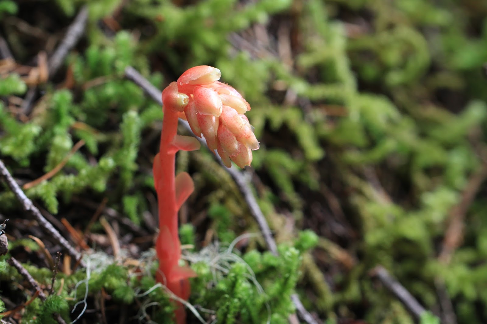
Left: Old Coralroot; Right: Ariolimax columbianus - Banana Slug
Old CoralrootAriolimax columbianus - Banana Slug

Trail Shots

View from Stujack Pass Looking West Over the Sauk RiverView from Stujack Pass Looking West Over the Sauk River

Left: Trail – ridge walk part – up to Mount Pugh; Right: View North with White Chuck Mountain and in the background Baker and Shuskan
Trail – ridge walk part – up to Mount PughView North with White Chuck Mountain and in the background Baker and Shuskan

Monday, June 22, 2015

Lost Creek Ridge Hike

Left: Lost Creek Ridge Hike Route; Right: Trail Through a Meadow Heading East
Lost Creek Ridge Hike RouteTrail Through a Meadow Heading East

Hike Notes

Length: 13.0 miles GPS in camera
Duration: About 8 hours, 9:20 am - 5:40 pm with a break for lunch
Elevation: Starting 1,875 ft, max at 5,875.
Location: North Cascades, Lost Creek Ridge / Round Lake

Overview

The star attractions in the shaded, lower part of the hike were orchids and heath family myco-hetrotropics (parasitic) plants like candysticks (Allotropa virgata) and pinedrops (Pterospora andromedea), and then Lily family Queen's Cup (Clintonia uniflora). In the meadows the usual suspects: bistort, valerian, lupin, columbine, daisies and more.

It's quite a climb to Bingley gap (> 2,000 feet), and you are still not  done until you do some more climbing to break into the meadows where your reward is at hand: leisurely meadow to meadow walking. From the meadows, Red Mountain, Bedal Peak, Sloan Peak and Glacier Peak seem so close.

We ate looking down on Round Lake, but did not go down for a visit, instead saving time to push on along the ridge. We turned around and start back to the car around 3:15pm before reaching Hardtack Lake.

Plant List

Photos in next section.

[Asteraceae] Aster Family
  Luina hypoleuca - Little-Leaf Silverback
  Petasites frigidus - Artic Sweet Coltsfoot
  Solidago multiradiata - Northern Goldenrod

[Caryophyllaceae] Pink Family
  Eremognne capillaris - Mountain Sandwort

[Cornaceae] Dogwood Family
  Cornus unalaschkensis - Western Bunchberry

[Ericaceae] Heather Family
  Allotropa virgata - Candystick
  Chimaphila umbellata - Pipsissewa, Common Prince's Pine
  Gaultheria shallon - Salal
  Monotropa hypopitys - Pinesap, Many-Flower Indian-Pipe
  Phyllodoce empetriformis - Pink Mountain-Heath
  Pterospora andromedea - Woodland Pinedrops

[Grossulariaceae] Currant/Gooseberry Family
  Ribes lacustre - Prickly Currant

[Liliaceae] Lily Family
  Clintonia uniflora - Queen's Cup
  Lilium columbianum - Columbian Lily

[Linnaeaceae] Flax Family
  Linaceae borealis - America twinflower

[Orchidaceae] Orchid Family
  Corallorhiza mertensiana - Western Coralroot
  Goodyera oblongifolia - Western Rattlesnake Plantain

[Orobanchaceae] Broomrape Family
  Castilleja parviflora - Mountain Indian Paintbrush
  Pedicularis bracteosa - Bracted Lousewort
  Pedicularis groenlandica - Elephanthead Lousewort

[Phrymaceae] Lopseed Family
  Erythranthe guttata - Seep Monkey-Flower

[Plantaginaceae] Plantain Family
  Penstemon davidsonii - Davidson's Penstemon
  Penstemon procerus - Small-Flowered Penstemon

[Primulaceae] Primose Family
  Dodecatheon jeffreyi - Jeffrey's Shooting Star

[Ranunculaceae] Buttercup Family
  Aquilegia formosa - Red Columbine, Western Columbine
  Thalictrum occidentale - Western Meadow-Rue

[Rosaceae] Rose Family
  Rubus lasiococcus - Dwarf Bramble
  Rubus parviflorus - Thimbleberry

[Saxifragaceae] Saxifrage Family
  Leptarrhena pyrolifolia - Leather Leaf Saxifrage
  Saxifraga mertensiana - Merten's Saxifrage
  Tiarella trifoliata - Three-Leaf Foam Flower

[Valerianaceae] Valerian Family
  Valerniana sitchensis - Sitka Valerian

Plant Photos

In approximate order from lowest to highest altitude.

Allotropa virgata – Candystick looking like a Christmas treat!
Candystick - Allotropa virgataCandystick - Allotropa virgata

Left: Corallorhiza mertensiana – Western Coralroot; Right: Pterospora andromedea - Woodland Pinedrops
Corallorhiza mertensianaPterospora andromedea - Woodland Pinedrops

Left: Pinesap - Monotropa hypopitys. Left with Linaceae borealis - America twinflower
Pinesap - Pinesap - Monotropa hypopitysPinesap - Pinesap - Monotropa hypopitys

Left: Cornus unalaschkensis - Western Bunchberry; Right: Chimaphila umbellata - Pipsissewa, Common Prince's Pine
Cornus unalaschkensis - Western BunchberryChimaphila umbellata - Pipsissewa, Common Prince's Pine

Left: Clintonia uniflora - Queen's Cup; Right: Tiarella trifoliata - Three-Leaf Foam Flower
Clintonia uniflora - Queen's CupTiarella trifoliata - Three-Leaf Foam Flower

Left: Ribes lacustre - Prickly Currant; Right: Thalictrum occidentale - Western Meadow-Rue
Ribes lacustre - Prickly CurrantThalictrum occidentale - Western Meadow-Rue

Left: A Drift of Aquilegia formosa - Red Columbine, Center: Artemisia Not Yet Blooming Trailside; Right: Valerian Snack for a Butterfly
 A Drift of Columbine Artemisia Not Yet Blooming TrailsideValerian Snack for a Butterfly

Left: Pedicularis groenlandica - Elephanthead Lousewort; Right: Penstemon davidsonii - Davidson's Penstemon
Pedicularis groenlandica - Elephanthead LousewortPenstemon davidsonii - Davidson's Penstemon

Left: Solidago multiradiata - Northern Goldenrod; Right: Luina hypoleuca - Little-Leaf Silverback
Solidago multiradiata - Northern Goldenrod Luina hypoleuca - Little-Leaf Silverback

Left: Eremognne capillaris - Mountain Sandwort; Right: Saxifraga mertensiana - Merten's Saxifrage
Eremognne capillaris - Mountain SandwortSaxifraga mertensiana - Merten's Saxifrage

Left: Phyllodoce empetriformis - Pink Mountain-Heath; Right: Castilleja parviflora - Mountain Indian Paintbrush
Phyllodoce empetriformis - Pink Mountain-HeathCastilleja parviflora - Mountain Indian Paintbrush

Left: Erythranthe guttata - Seep Monkey-Flower; Right: Dodecatheon jeffreyi - Jeffrey's Shooting Star
Erythranthe guttata - Seep Monkey-FlowerDodecatheon jeffreyi - Jeffrey's Shooting Star

Left: Glacier Peak Viewed from the Lost Creek Ridge Trail; Right: Round Lake

Left: Sloan and Bedal Peaks Looking South from the Lost Creek Ridge Trail; Right: Example of the “Vertical Meadows”.
Sloan and Bedal Peaks Looking South from the Lost Creek Ridge TrailExample of the “Vertical Meadows”

Monday, October 20, 2014

Park Butte – Easton Glacier Hike

West side of the Easton Glacier
Side of the Easton Glacier

Our Hike Route of Park Butte Fire Lookout and Easton Glacier (via Canon GPS Logger and Google Earth)

Hike Notes

Length: 12.5 miles
Duration: 8.5 hours, 9:20 am – 5:50 pm inclusive of a 45 min lunch break.
Elevation Gain: Trailhead: WTA - 3,250 ft (WTA), Garmin** - 3,347 ft, Canon* - 3,357 ft. Highest point at edge of Easton Glacier: Garmin - 6,423 ft, Canon - 6,411 ft. Total elevation gain: Garmin - 4,150 ft, Canon - 4, 877.
Location: North Cascades -- West Slope

* Canon GPS Receiver, ** Garmin HCX

Overview

For our 10th and possibly last hike of the 2014 season, we hiked up to the Park Butte historic fire lookout and then took a stroll alongside the west side of the Easton Glacier (WTA site). We have racked up 131.7 total miles this season, inclusive of this hike and beating our 115.2 total miles last year.

First stop for us was the Park Butte historic fire lookout. At the fire lookout we had about 45 minutes of just us two and nobody else inside. We sat staring at Mount Baker, eating lunch and reading the various journals and information sheets left inside. After our lookout lunch, we headed back to the junction of the Park Butte Trail and the Railroad Grade Trail, which takes you toward the Easton Glacier. We decided that we would just take a peak at the glacier, and head back to pick up the Scott Paul Trail back to the trailhead. However, once we got saw the glacier, we knew we wanted to walk up beside it. We followed the Railroad Grade to get to the Easton Glacier, which is a lateral moraine formed as the glacier retreated. We were walking on a ridge where, on one side there is green high meadow, and to the other, a sharp drop down into emptiness where the glacier once was. We got up to 6,500 feet, above High Camp and then called it a day and headed back.

Left: View from the Fire Lookout Toward Mt Baker; Right View from 6,500 feet near the Easton Glacier, Looking South
View from the Fire Lookout Toward Mt BakerRight View from 6,500 feet near the Easton Glacier, Looking South


Fly Amanita. Left: Dirty Toadstool? Right: Toadstools and Heather
Fly AmanitaFly Amanita

Left: A Marmot near High Camp; Right: A Gray Jay - Perisoreus canadensis
A Marmot near High CampA Gray Jay - Perisoreus canadensis

Left: Another View of Our Hike Route of Park Butte Fire Lookout and Easton Glacier (via Canon GPS Logger and Google Earth); Right: Lincoln Peak
Our Hike Route of Park Butte Fire Lookout and Easton Glacier (via Canon GPS Logger and Google Earth)Lincoln Peak

Park Butte Fire Lookout. Left: Outside; Right: Looking Inside
Park Butte Fire Lookout. Outside.Park Butte Fire Lookout. Looking inside.

Left: A Lunch Table in the Park Butte Fire Lookout; Right: View from the Fire Lookout


Hiking on the East Glacier Lateral MoraineHiking on the East Glacier Lateral MoraineHiking on the East Glacier Lateral Moraine


Vaccinia - Blueberries in Morovitz Meadow
Blueberries in Morovitz MeadowBlueberries in Morovitz Meadow


Left: West side of the Easton Glacier; Right: Park Butte trail wall made of log ends.
West side of the Easton GlacierPark Butte trail wall made of log ends