Left: Silhouette of Fishermen in Whale Channel; Center: A Rod Set on the Downrigger Waiting for a Bite; Right: Motoring Out to Alexander Island


This post is in the form of a list of frequently asked questions (FAQ) intended for the non-fisherman going to West Coast Resorts, Whale Channel Lodge. This was my first experience salmon fishing and spending time in this part of British Columbia. Here are some obvious and not so obvious questions that I asked during my four day stay. Fish on.
Where is this place?
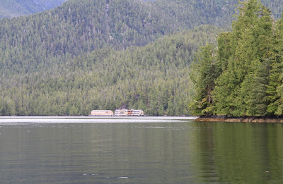
The resort (at least this year) was in Barnard Harbour, an inlet of Princess Royal Island, which is included in the Kitimat-Stikine, BC, a regional district of Canada. The resort floats and is towed to different locations, seasonally. The resort is a converted barge that is positioned in a calm area and from what we heard runs completely from diesel. Water is desalinated for drinking water. Waste water is treated and released.
Left: Map Location of Barnard Harbour in British Columbia (Google Maps); Right: View of West Coast Resort Whale Channel in Barnard Harbour

How do I get there?
We left travelled from Vancouver airport to Bella Bella by turboprop jet and then on to Barnard Harbour by Helijet.
Left: Helijet on Floating Landing Pad in Barnard Harbour; Right: Layers of Princess Royal Island


Do I have to know anything about fishing?
Nope. A little knowledge helps, but the guides will fill you in on everything you need to know. Spoiler alert: you use this device called a down rigger to weigh down your fishing line to a particular depth (37 / 47 feet are popular) and you drive around trolling for salmon. When you get a bite, keep your pole up, tension on, and reel the fish in. (Okay, it’s way more than that, but that’s my brief description.) And, since you typically have two lines trailing the boat you keep them at different depths so they stay out of each other’s way. So practical.
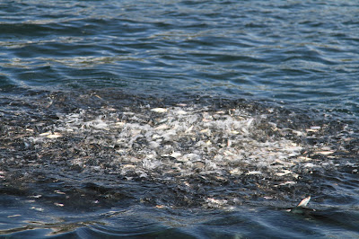
Left: Bait Ball of Herring at the Surface South End of Campania Island; Right: Motoring Back to the Lodge After a Day of Fishing

Where do I fish?
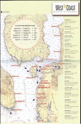
Each boat has a map with the “typical” fishing spots. Your guide will suggest a good location. And, throughout the day, boats keep in radio contact to share tips on where the fishing is good. We spent the most time around Alexander Island (at the south end of Campania Island) and Eclipse Point.
Left: Alexander Island and Campania Island from the Helijet; Right: Map of Whale Channel Fishing Spots

What kind of fish will I catch?
On each boat there is a “Know Your Salmon Species” card (the flip side of the fishing spots info) that you’ll find yourself consulting a lot. The four species listed on the card are chinook (aka king or spring or Tyee*), coho (silver), chum (dog), and pink (humpback). We caught almost exclusively chinook and coho. We often could not tell which species we had until we hauled it up on board and opened its mouth to look at the gums. It’s all about the gums and tails.
* greater than 30 lbs.
Left: Chinook and Coho in the Fish Hold with Tags Identifying Who the Fish Belongs To; Right: Know Your Salmon Species Information


What other wildlife will I see besides fish?
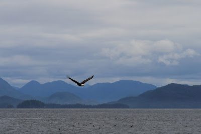
Here are a few of the animals we saw: steller sea lions, eagles, rhinoceros auklets, pacific white-sided dolphin, and humpback whales. Your mileage may vary. Keep your eyes open.
Left: Stellar Sea Lions Near Ashdown Island; Right: Eagles Feasting on a Bait Ball Near Alexander Island


Left: Whale Blow in the Morning Near Alexander Island; Right: Whale Surfacing Near Alexander Island


How many salmon can I catch?
It’s complicated. See the BC Sport Fishing Guide. Here’s what I think I understand of the rules: we could catch up to two chinook a day and four coho a day, but only four total fish day. We could take up to 8 total salmon out of the country. Four chinook and four coho. The math still confuses me. And, if you are there for several days, it’s a bit of a guessing game as to what to keep and what to throw back. You don’t want to spend your fish allowance too quickly because you could catch the big one the last day!
What are those things attached to the salmon?
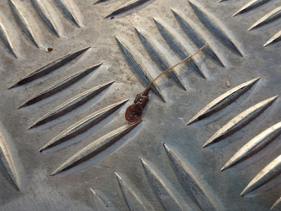
Lice. Yup, salmon have lice (Lepeophtheirus salmonis). They are easy to pick off and they shouldn’t be considered detrimental to the quality of the fish, unless I suppose there were a lot of them (lice that is). Anyhow, there only seemed to be a few attached to the fish we caught. And, they seem to be quite often attached near the anal area of the fish. I took one off and flipped it on it’s back and it waved its legs in the air, desperately grasping to attach to something.
Left: Salmon Louse on a Salmon; Right: Salmon Louse Detached from Its Host

How do I kill the fish if I decide to keep it?
You bonk it on the head with a fish bat, put it in the hold, and gill it – at least that’s what I was taught. Throw water on top of it every so often until you get back to dock.
How do I take my fish home?
Oh, the folks at West Coast Resorts do all the hard work. If you can get your fish into the hold and your boat back to dock, you’re golden. The staff will take care of the rest: fillet, pack, and freeze it. When we arrived in Vancouver airport, boxes of fish were waiting for us. Fish on ice, that’s nice.
Left: Salmon Freshly Filleted Back at the Dock in Whale Channel; Right: Arriving at Vancouver Airport and Picking Up Our Boxes of Fish

+of+Fish+at+the+Vancouver+Airport.JPG)
What should I bring/wear?
Bring outdoor clothes that you’re comfortable in and could wear to dinner. You won’t trash your clothes, because likely you’ll choose to wear the rubberized overalls and a big heavy jacket provided by the resort. I will suggest to bring a pair of gloves (or buy them in the small gift shop at the resort) if you have “delicate” hands like I do. If you want to buy them before coming, you can look for “angler gloves”. Also, a warm cap that covers your ears is nice if your head gets cold easily.
Bugs? We weren’t bothered much by bugs on the water. They bothered us a little at the lodge if we hung around the fish processing area. However, we did not wear any bug repellant the four days we were there and we were just fine. A few in our group reported some bites from black flies. “Black flies” seems to the catchall term for something that bites, looks like a fly, and we don’t know the name of. A dead one is pictured below.


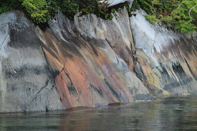
What are all the colors I see on the coastline at low tide?
Glad you asked, it’s called intertidal zonation. In the photos here you can see several zones. The black zone toward the top is the spray or backshore zone. It is exposed to salt spray and is characterized by the black encrusting lichens (Verrucaria). Just below the spray zone is the intertidal zone, flooded once or twice a day, and characterized by a light brown zone that becomes darker closer to the water. In total, there are five zones: backshore, spray, intertidal, subtidal fringe, and subtidal.
Left: Intertidal Zonation Colors at Alexander Island; Right: View of South End of Campania Island


Left: Another View of Intertidal Zonation; Right: Different Coloration in Barnard Harbour, Iron Oxide?

Will I step foot on land during my time there?
No. I asked and got a blank stare. I thought a nice little passeggiata might be nice between fishing jaunts. Nope. Land is generally inaccessible and potentially dangerous. Sigh.
Left: An Abandoned Boat in Barnard Harbour; Right: Eagle in Flight and Layers of Princess Royal Island

Why does the land look lush in some spots and stark and swampy in others?
From the air, the islands look like a tonsure, with a ring of trees around the perimeters. And, in stands of tree, there is often what look like dead tree or at least, dead tops. Why? We’ll it took a little digging to find out.
First, the West Coast Whale Channel resort, which is located between Bella Bella and Prince Rupert on the North Coast, is part of the Coastal Western Hemlock (CWH) Biogeoclimatic Zone. In the brochure on the gov.bc.ca site for CWH, this description of Wetlands caught my interest:
Not all of the Coastal Western Hemlock Zone is forested and not all of the forest is characterized by big trees. Wetlands, particularly bogs, are common in coastal lowland areas. They range from “closed” bog forests with scrubby and irregular tree cover to “open” bogs with few trees.
Okay, now we are getting somewhere. When flying in and out (via Helijet from/to Bella Bella), we noticed many coastal islands (large and small) with wetlands (fresh water) and that around these areas, there were little to no trees. What trees there were in the wetlands, were stunted. The CWH is the rainiest biogeoclimatic zone in British Columbia, but doesn’t the rain drain away?
In random search forays, I found something on Dewdney Island. The Dewdney and Glide Islands Ecological Reserve is a research area is in the Estevan Group, just due west by two islands from Whale Channel. The reserve contains “extensive bog and fen ecosystems representative of outer islands along the north mainland coast.” Ah, now we are getting somewhere. Furthermore, in the detailed description of the reserve, there is this information:
Dewdney Island is characterized by an outer rim of forest and interior area of wetland, the latter making up 60 to 75% of the total land area. Extensive occurrence of fen, bog and scrub vegetation, which occurs on both flat and gently sloping surfaces, is attributable to the subdued topography, moist climate, and lack of surficial materials conducive to development of forest soils. Forests are restricted to steep, well drained slopes and to a fringe near the shoreline where sands and gravels overlie the bedrock and nutrient supplies are better.
Left: Map of Dewdney Islands in the Estvean Group (Google Maps) Showing Fringe of Trees; Right: View of Princess Royal Island Looking West from the Helijet


Bingo, our tonsure of trees. I guess “subdued topography” in this context means that water accumulates and leads to more acidic conditions typical of wetlands.
Continuing for a moment with Dewdney Island, I found Brief notes on a field trip to Dewdney Island (ER#25), June 1987 where the authors and a malamute husky visited the island for four days, sampling 28 lakes on the island as part of coastal stickleback populations research. This June 7th entry stuck out for me:
Our faces and hands are now bloody from the blackflies and we have to wear netting over our heads and as well wear gloves to protect our hands. Where the net tucks into the collar, it presses against the skin and the blackflies are able to bite through the net and obtain their bit of flesh. With this density of flies, it is no wonder that the stickleback were as abundant as they were.
So, I guess stepping foot on land is not such a good idea?
So what’s left? The dead tops. In the gov.bc.ca brochure mentioned above, there was also this description of the Spiked-top Cedars:
In the wet conditions of the outer coast [where the resort is], old western red cedar and yellow-cedar trees often develop dead or “spiked” tops. Cedars require lots of calcium, especially for the proper development of their tops. Scientists think the dead tops of these trees are caused by calcium deficiencies in the moist, acidic soils of these areas.
And, finally, wind is controlling factor of tree height on the coast explaining why so many of the islands have a very uniform tree height at shoreline, when viewed from the water.
Left: Time to Go; Right: Last Glimpse of the Lodge

![]()
.jpg)
![]()



+of+Fish+at+the+Vancouver+Airport.JPG)


