Showing posts with label sedona. Show all posts

Wednesday, August 15, 2012

Two Sedona Hikes: Devil’s Bridge and West Fork

Devil’s Bridge (left) and West Fork of Oak Creek (right)
Devil's Bridge, SedonaWest Fork of Oak Creek, Sedona
We’ve been using the book Sedona Top 10 Hikes by Denis Andres as our main guide for hikes around Sedona. Since we are still new to the hikes in the area, this book has been more than enough to get us started. Here are two hikes we did in late July 2012.

Devil’s Bridge Hike

We turned off of Dry Creek Road as instructed and on to Forest Road 152 as instructed in Sedona Top 10 Hikes, but after a minute or so decided that driving our rental car on 152 was not a good idea. So, we parked at the start of 152 (there is a little parking area with an information board) and walked the 1.3 miles to the parking lot at the trail head for “Devil’s Bridge #120”. From the trail head it is just over another mile to get to the bridge. You can spend time below the bridge looking up on it, above the bridge looking down on it, or, on the bridge (which we didn’t do). Roundtrip, it took us from 5:00 am to 7:45 am. What were we doing up so early? Our balloon ride (4:30 am pickup) got canceled and we were up anyway so the hike was one way to beat the midday heat and hike in the morning, which we almost never do. Here’s the bridge on a map.

The surrounding pinon-juniper forest is quite something to be in. While walking through it, the trees are spaced out. Looking down on it you see a sea of green (pinon) and bluish-green (juniper).

Agave parryi – Parry’s Agave or Century Plant Spike (left) and Arctostaphylos pungens – Pointleaft Manzanita (right)
Agave parryi – Parry’s Agave or Century Plant Spike Arctostaphylos pungens – Pointleaft Manzanita

Cupressus arizonica – Arizona Cypress Cones (left) and Datura wrightii – Sacred Datura (right)
Cupressus arizonica – Arizona Cypress Cones Datura wrightii – Scared Datura

View Toward Enchantment Resort over Nolina microcarpa – Beargrass (left) and Purshia mexicana - Mexican Cliffrose (right)
View Toward Enchantment Resort Purshia mexicana - Mexican Cliffrose

Views of Devil’s Bridge
View of Devil's Bridge, SedonaView of Devil's Bridge, SedonaView of Devil's Bridge, Sedona

Barks: Juniperus sp. (left and right)
Juniperus scopulorum BarkUnidentified Juniperus sp. Bark

Pinon-Juniper Forest Scene Near Devil’s Bridge (left) and View from Devil’s Bridge (right)
Pinon-Juniper Forest Scene Near Devil’s Bridge View from Devil’s Bridge

Looking Up at Devil’s Bridge (right) and Looking Over Devil’s Bridge Earl Morning as Storm Clouds Move Away (right)
Looking Up at Devil’s BridgeLooking Over Devil’s Bridge Earl Morning as Storm Clouds Move Away

Devil’s Bridge Trailhead Signage

West Fork Hike

The day after Devil’s Bridge, we hiked the West Fork. You drive out the north end of Sedona on 89A. You are driving along Oak Creek. You pass Slide Rock State Park, Encinoso Picnic Area, Junipine Resort, Junipine Resort, and Hoel’s Indian Shop before you pull into Shady Lane. After you cross the stream the first time you walk through an old orchard and then come up to the ruins of Mayhew’s Lodge. It was at one time listed on the National Register of Historic Places, but burned down in 1980. Read more on the history of the lodge here.

This is an interesting hike that we only scratched the surface on. We ambled about 1.5 miles into the creek (the West Fork of Oak Creek) and 1.5 miles back out. The official trail goes into the canyon about 3.2 miles with very little elevation gain. We did this hike late in the day and while it was warm, being in the canyon and mostly out of the sun and near water, made the hike very tolerable. Our advice: wear shoes you won’t mind getting wet because there are spots where you’ll just want to splash around and try to catch tadpoles as we did.

Old Orchard Near Mayhew Lodge Ruins (left) and Inside West Fork, Canyon Walls (right)
Old Orchard Near Mayhew Lodge Ruins  Inside West Fork, Canyon Walls

Exploring the West Fork (left) and Splashing Around (right)
Exploring the West Fork Exploring the West Fork

Monday, August 6, 2012

Balloon Ride Over Sedona

We’ve ridden with Red Rock Balloons twice now and have had a great experience both times. The first time we went up in December 2010, we went up as a single balloon (16 person basket). The second time, in July 2012, we were part of a group of three balloons, again in a 16 person basket. Our route each flight we different, dictated by the wind. Both times we launched off of a spot just west of Dry Creek Road.

Travelling with a group of balloons is interesting as you have perspective of the balloons moving up and down with respect to each other.

2010 Balloon Ride Over Sedona – Balloon Shadow on Cockscomb
Balloon Shadow on Cockscomb Balloon Shadow on Cockscomb

2010 Cockscomb (left) and Doe Mesa (right)
CockscombDoe Mesa

2010 Inflating the Balloon on the Ground (left) and Deer in Coconino Forest – View from Balloon(right)
Inflating the Balloon on the Ground Deer in Coconino Forest – View from Balloon

2010 Looking Northeast to Mount Elden (left) and Doe Mesa (right)
Looking Northeast to Mount EldenDoe Mesa
2010 Red Rock and Colorado Plateau

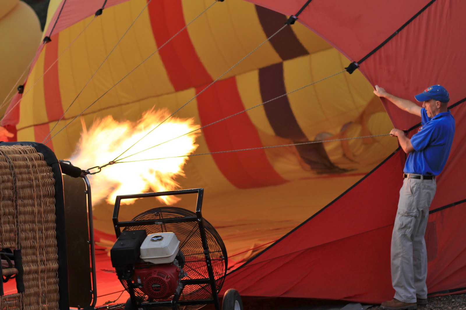
2012 Balloon Ride Over Sedona – Inflating (left) and Getting Ready to Get in the Basket (right)
2012 Balloon Ride Over Sedona - InflatingGetting Ready to Get in the Basket

2012 Getting the Balloon Upright (left) and The Pilot Going over Protocol (right)
2012 Getting the Balloon Upright The Pilot Going over Protocol

2012 And We’re Off – Chasing Other Balloons
2012 And We’re Off – Chasing Other Balloons2012 And We’re Off – Chasing Other Balloons

2012 The Sun Rising (left) and Casting Shadows (right)2012 The Sun Rising2012 Casting Shadows

2012 Sailing Over Highway 89A Looking Toward Jerome (right) and the Treatment Plant (left)

2012 Shadow on Dry Creek Bluff (left) and Two Deer Chasing a Coyote – Really! (right)
2012 Shadow on Dry Creek Bluff Two Deer Chase a Coyote – Really

2012 Balloon Ride Over Sedona – Rising Out of a Creek (left) and Follow Us (right)
    

2012 Another Balloon Lands Nearby (left) and Ground Crew Awaits for Our Landing (right)

Saturday, August 4, 2012

Sedona, Center for the New Age - Mural

Sedona, Center for the New Age - Mural
We were walking on our way to Elote one hot night when we stopped to snap this photo of a mural on the side of the Center for the New Age in Sedona, Arizona The building is located on Oak Creek in the shade of huge sycamores. We have never been inside the center - though the aura pictures blipped on our skeptics’ radar. (Most of the example aura pictures we’ve seen look like a photo of people wearing colorful clown wigs.)

Yes, the appetizer at Elote called “Elote” was delicious. Elote is Spanish (Mex) for corn. The appetizer is fire roasted corn with spicy mayo, lime and Cotija cheese - was delicious. Wonder if your aura would be different after eating a bowl of it?