Showing posts with label central cascades. Show all posts

Sunday, October 5, 2014

Lake Ingalls Hike

Left: Our Lake Ingalls Hike Route (via Canon GPS Logger and Google Earth); Right: A Marmot Watches Us Below Lake Ingalls
Our Hike Route for Lake Ingalls (via Canon GPS Logger and Google Earth)A Marmot Watches Us Below Lake Ingalls

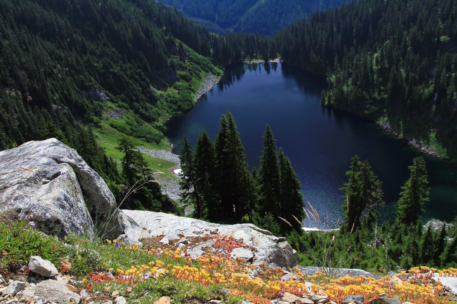
Left: Gold Larches Near Ingalls Pass; Right: Looking West Over Lake Ingalls Toward Mt. Stuart
Gold Larches Near Ingalls PassLooking West Over Lake Ingalls Toward Mt. Stuart

Hike Notes

Length: 11.8 miles
Duration: 7.5 hours (9:00 am – 4:30 pm), includes 40 minute lunch break
Elevation Gain: 5,756* / 3,591** ft - low point 4,235* ft/4,288** ft @ trailhead; high point 6,550 ft @ Lake Ingalls
Location: Snoqualmie Pass -- Salmon La Sac/Teanaway

* Canon GPS Receiver, ** Garmin HCX - Our elevation data for this hike suffers from a couple of problems. First, the Garmin was off for part of the middle of the hike, and the Canon GPS Receiver logger turned off for the last ¼ of the hike. Technology. We calculated our total hike length by using the visible trail in Google Earth.

Overview

For our ninth hike of the 2014 season, we took a loop hike around Lake Ingalls (WTA site) and down through Ingalls Creek. We have racked up 119.2 total miles this season, inclusive of this hike. (Our last hike of 2013 was to Carne Mountain, which brought us to 115.2 miles total.)

Our Lake Ingalls route was a loop that had us taking the standard route up to the lake, skirting the west edge of the lake, dropping down by and following Ingalls Creek, and the climbing up the east side of Longs Pass to rejoin the Lake Ingalls trail. The climb up Longs Pass caught us by surprise because we were tired by that point in the hike and weren’t expecting the steep climb to the pass (40-50% grade toward the top). We usually don’t use trekking poles, but we broke them out for the last 200 feet of elevation gain to get over the pass, at approximately 6,100 feet.

Lake Ingalls on this sunny, warm Fall Sunday was not too crowded. Most hikers seem to stop at the south end of the lake and then turn around and head back. We picked our way around the west side of the lake. We saw others going around the east side as well.

On the hike down to Ingalls Creek, we saw nobody. That part of the trail gets a little monotonous. The sign to Longs Pass was a welcome site. We hike up Ingalls Creek in 2012 (see Ingalls Creek Trail - Butterflies and Balsamroot) but didn’t come this far up the creek.

On our way to Lake Ingalls we saw one goat and a few marmots. In terms of larches, we thought the larches we saw on our Carne Mountain last year were more spectacular.

Left: The Obligatory Goat Photo Near Ingalls Pass; Right: Welcome to Alpine Lakes Wilderness (Okanogan-Wenatchee) – Sign
The Obligatory Goat Photo Near Ingalls PassWelcome to Alpine Lakes Wilderness (Okanogan-Wenatchee) – Sign

Left: Fern; Right: View of Mt Stuart from Ingalls Pass
FernView of Mt Stuart from Ingalls Pass

Looking Toward the North End of Lake IngallsLooking Toward the North End of Lake Ingalls

Left: Rock Near Lake Ingalls; Right: Diagonal Lines Including Mt Stuart in the Background
Rock Near Lake IngallsDiagonal Lines Including Mt Stuart in the Background

Left: Sign on Ingalls Creek Pointing the Way to Longs Pass Trail; Right: Signs Pointing to Lake Ingalls
Sign on Ingalls Creek Pointing the Way to Longs Pass TrailSigns Pointing to Lake Ingalls

Sunday, August 10, 2014

Kendall Katwalk (and Beyond) – Hike


Left: View of the Kendal Katwalk, Looking North; Right: Hike KML Profile from Canon GPS Logger
 Hike KML Profile from Canon GPS Logger

Hike Notes

Length: 22.1 miles (according to Garmin HCX)
Duration: 10.5 hours (7:30 am – 6:00 pm)
Elevation Gain: 4,565 ft (total), 5,583 ft max elevation, starting @ 3,058 ft
Location: Snoqualmie Pass

For our fifth hike of the 2014 summer (and bringing us to 72.5 total miles this season), we decided to tackle the part of the Pacific Crest Trail that starts at Snoqualmie Pass and heads north over the Kendall Katwalk. WTA reports it as 11 miles roundtrip to the Katwalk. We decided to push on through since the scenery was so spectacular. We made it around Joe Lake to the Huckelberry-Chikamin saddle. There were parts of the trail after Kendall Katwalk that were outstanding in terms of wildflowers, in particular, as the trail passes above Lake Alaska and Joe Lake.

The only downside is of this hike is the first few miles where you don’t escape the roar of I-90.

As to the “katwalk” it isn’t all that scary. It’s a short stretch (200/300 feet?). It’s wide enough to let people pass. And, in my opinion, it was no worse than sections of the trail north of it.

Plants

Format: [Family] Genus species (Common Name). Links are to WTU Image Collection, which I found useful for identifying a couple of plants that stumped me here. My standbys for plant identification are given in the post Mount Rainier National Park, Summerland – Panhandle Gap Hike.

[Apiaceae] Lomatium sp.
[Asteraceae] Agoseris aurantiaca (Orange agoseris)
[Asteraceae] Arnica lanceolata (Clasping Arnica)
[Asteraceae] Artemisia campestris (Field Sagewort, Field Wormwood)
[Asteraceae] Artemisia ludoviciana (White Sagebrush, Gray Sagewort)
[Asteraceae] Hieracium aurantiacum (Orange Hawkweed, Devil’s Paintbrush)
[Asteraceae] Luina hypoleuca (Silverback Luina, Littleleaf Luina)
[Asteraceae] Rainiera stricta (Syn: Luina stricta) (False Silverback)
[Caprifoliaceae] Sambucus racemosa (Red Elderberry)
[Caryophyllaceae] Silene parryi (Parry’s Silene, Parry’s Catchfly)
[Crassulaceae] Sedum oreganum (Oregon Stonecrop)
[Ericaceae] Pterospera andromeda (Pinedrops)
[Ericaceae] Vaccinium membranaceum (Black Huckleberry)
[Orobanchaceae] Pedicularis ornithorhyncha (Bird’s Beak Lousewort)
[Orobanchaceae] Pedicularis contorta (Coiled Lousewort)
[Orobanchaceae] Pedicularis racemosa (Sickletop Louseword)
[Polygonaceae] Polygonum davisiae (Davis’ Knotweed) syn. Polygonum newberryi (Newberry’s Knotweed)
[Pteridaceae] Cryptogramma acrostichoides (American Parsley Fern)
[Rosaceae] Luetkea pectinata (Patridgefoot)
[Rosaceae] Sanguisorba stipulata (Canadian Burnet, Sitka Burnet)
[Saxifragaceae] Micranthes ferruginea (Rusty Saxifrage)

Rainiera stricta (Syn: Luina stricta) (False Silverback) plant (left) and flowers (right)
Rainiera stricta (Syn: Luina stricta) (False Silverback)Rainiera stricta (Syn: Luina stricta) (False Silverback)

Left and Center: Sanguisorba stipulata (Canadian Burnet, Sitka Burnet); Right: Pterospera andromeda (Pinedrops)
Sanguisorba stipulata (Canadian Burnet, Sitka Burnet)Sanguisorba stipulata (Canadian Burnet, Sitka Burnet)Pterospera andromeda (Pinedrops)

Left: Agoseris aurantiaca (Orange Agoseris); Right: Hieracium aurantiacum (Orange Hawkweed, Devil’s Paintbrush)
Agoseris aurantiaca (Orange Agoseris)Hieracium aurantiacum (Orange Hawkweed, Devil’s Paintbrush)

Left: Arnica lanceolata (Clasping Arnica); Right: Lomatium Flower Head with Fruits
Arnica lanceolata (Clasping Arnica)Lomatium Flower Head with Fruits

Artemisia ludoviciana (White Sagebrush, Gray Sagewort) flowers (left) and plant (right) Artemisia ludoviciana (White Sagebrush, Gray Sagewort)Artemisia ludoviciana (White Sagebrush, Gray Sagewort)

Left: Cryptogramma acrostichoides (American Parsley Fern); Right: Luetkea pectinata (Patridgefoot) along a talus
Cryptogramma acrostichoides (American Parsley Fern) Luetkea pectinata (Patridgefoot)

Left: Luina hypoleuca (Silverback Luina, Littleleaf Luina); Right: Luina with Paintbrush
 Luina hypoleuca (Silverback Luina, Littleleaf Luina)Luina with Paintbrush


Left: Pedicularis contorta (Coiled Lousewort); Right: Pedicularis ornithorhyncha (Bird’s Beak Lousewort)
Pedicularis contorta (Coiled Lousewort)Pedicularis ornithorhyncha (Bird’s Beak Lousewort)

Left: Polygonum davisiae (Davis’ Knotweed); Right: Vaccinium membranaceum (Black Huckleberry)
Polygonum davisiae (Davis’ Knotweed)Vaccinium membranaceum (Black Huckleberry)

Silene parryi (Parry’s Silene, Parry’s Catchfly) front view (left) and side view (right)
Silene parryi (Parry’s Silene, Parry’s Catchfly)Silene parryi (Parry’s Silene, Parry’s Catchfly)

Left: Sedum oreganum (Oregon Stonecrop); Right: Micranthes ferruginea (Rusty Saxifrage)
Sedum oreganum (Oregon Stonecrop)Micranthes ferruginea (Rusty Saxifrage)

Views of Alaska Lake
View of Alaska LakeView of Alaska Lake

Left: View from approximately the midpoint of Kendall Katwalk, looking north; Right: Mountains to the west from south end of the Katwalk including Red MountainView from approximately the midpoint of Kendall KatwalkMountains to the west from south end of the Katwalk including Red Mountain

Left: View from the Pacific Crest Trail near Joe Lake, looking toward Huckleberry Mountain (left in the photo) and Chikamin Peak; Right: View from Trail near Ridge Lake, looking north
View from the Pacific Crest Trail near Joe Lake, looking toward Huckleberry Mountain (left in the photo) and Chikamin PeakView from Trail near Ridge Lake, looking north

Left: View of the steep ridges of the Cascades; Right: View south from the Pacific Crest Trail toward Mount Rainier, with Tinkham Peak in mid-ground of photo
View of the steep ridges of the CascadesView south from the Pacific Crest Trail toward Mount Rainier

Saturday, July 26, 2014

West Fork Foss River and Lakes


Left: Green Insect on Angelica; Right: Google Earth Hike KML for West Fork Foss River
A Bug’s Single Bar: Kneeling AngelicaGoogle Earth Hike KML

Hike Notes

Length: 15* miles roundtrip (WTA reports it as 13.0)
Duration: 9.25 hours
Elevation Gain: 5,841 ft (starting 1,658 ft, max 4,938 ft)
Location: Central Cascades, Stevens Pass West

* We recorded 15 miles because we took the detour to Lake Malachite, and we walked a bit further around Big Heart Lake. Our measurements come from a Canon GPS logger.

Our third day hike of the 2014 season and a tough one at that. We had sunny skies, warm temperatures, lakes, incredible terrain, and relatively few mosquitoes, what’s not to like about that. On the hike, we visited five lakes, in order: Trout Lake (elev. 2,000 feet), Lake Malachite (4,098 feet), Copper Lake (3,961 feet), Little Heart Lake (4,204 feet), and Big Heart Lake (4,545 feet). In our opinion, Copper Lake is the prettiest and most accessible.

Plants and Fungi
[Family] Genus species (Common name)

[Pteridaceae] Adiantum aleuticum (Western Maidenhair Fern)
[Asteraceae] Anaphalis margaritacea (Pearly Everlasting)
[Apiaceae] Angelica genuflexa (Kneeling Angelica)
[Cladoniaceae] Cladonia macilenta (Lipstick Cladonia)
[Orchidaceae] Corallorhiza mertensiana (Western Coralroot - Orchid)
[Ericaceae] Elliottia pyroliflorus (Copperbush)
[Rosaceae] Geum macrophyllum (Large-leaved Avens)
[Ericaceae] Hypopitys monotropa (Pinesap, Dutchman’s Pipe)
[Liliaceae] Lilium columbianum (Columbia Lily)
[Caprifoliaceae] Linnaea borealis (Twinflower)
[Lobariaceae] Lobaria pulmonaria (Lungwort)
[Scrophulariaceae] Penstemon serrulatus (Cascades Penstemon)
[Lamiaceae] Prunella vulgaris (Self-heal)
[Rosacaea] Rubus lasiococcus (Dwarf Bramble)
[Rosaceae] Rubus parviflorus (Thimbleberry)
[Rosaceae] Rubus spectablis (Salmonberry)
[Adoxaceae[ Sambucus racemosa (Red Elderberry)
[Asteraceae] Senecio triangularis (Arrow-leaved Groundsel)
[Rosaceae] Sorbus sitchensis (Sitka Mountain-Ash)
[Liliaceae] Stenanthium occidentale (Mountainbells)
[Rosaceae] Spirea douglasii
[Rosaceae] Spirea spendens (S. densiflora)
[Saxifragaceae] Tiarella trifoliata (Foamflower)
[Melanthiaceae] Xerophyllum tenax (Bear Grass)

Butterfly: Parnassius clodius (Clodius Parnassian)
Parnassius clodius (Clodius Parnassian)

Anaphalis margaritacea (Pearly Everlasting)
Anaphalis margaritacea (Pearly Everlasting)Anaphalis margaritacea (Pearly Everlasting)

A Bug’s Single Bar: Kneeling Angelica
A Bug’s Single Bar: Kneeling AngelicaA Bug’s Single Bar: Kneeling AngelicaA Bug’s Single Bar: Kneeling AngelicaA Bug’s Single Bar: Kneeling Angelica

Trout Lake
Trout Lake

Malachite Lake
Malachite Lake

Copper Lake
Copper Lake

Little Heart Lake
Little Heart Lake

Big Heart Lake
Big Heart Lake

Viewing Malachite Lake Behind the Photographer (miniature effect) and a Tree Hugger on the West Fork Foss River?
Viewing Malachite Lake Behind the Photographer (miniature effect)Tree Hugger

Corallorhiza mertensiana (Western Coralroot - Orchid)
Corallorhiza mertensiana (Western Coralroot - Orchid) Corallorhiza mertensiana (Western Coralroot - Orchid)

Left: Adiantum aleuticum (Western Maidenhair Fern); Right: Vaccinium ovalifolium?
Adiantum aleuticum (Western Maidenhair Fern) Vaccinium ovalifolium

Left: Elliottia pyroliflorus (Copperbush); Center: Geum macrophyllum (Largeleaf Avens); Right: Sambucus racemosa (Red Elderberry)
 Elliottia pyroliflorus (Copperbush)Geum macrophyllum (Largeleaf Avens)Sambucus racemosa (Red Elderberry)


Right: Hypopitys monotropa (Pinesap, Dutchman's Pipe); Right: Lilium columbianum
Hypopitys monotropa (Pinesap, Dutchman's Pipe) Lilium columbianum

Penstemon serrulatus? (Cascades penstemon)
Penstemmon serrulatus (Cascades penstemon)Penstemmon serrulatus (Cascades penstemon)Penstemmon serrulatus (Cascades penstemon)

Left: Rubus lasiococcus (Dwarf Bramble); Right: Prunella vulgaris (Selfheal)
Rubus lasiococcus (Dwarf Bramble)Prunella vulgaris (Selfheal)

Left: Rubus parviflorus (Thimbleberry) Immature Fruit; Right: Rubus spectablis (Salmonberry) Flower
 Rubus parviflorus (Thimbleberry) Immature FruitRubus spectablis (Salmonberry) Flower

Senecio triangularis (Arrow-leaved Groundsel) Leaves and Flower

Left: Sorbus at Lake Malachite; Right: Thistle Trailside
Sorbus at Lake MalachiteThistle Trailside

Left: Spirea douglassi (hardhack); Right: Spirea spendens (by Lake Malachite)
Spirea douglassi (hardhack)Spirea spendens (by Lake Malachite)

Stenanthium occidentale (Mountainbells)
Stenanthium occidentale (Mountainbells)Stenanthium occidentale (Mountainbells)

Tiarella trifoliata
(Foamflower)
Tiarella trifoliata (Foamflower)Tiarella trifoliata (Foamflower)