Showing posts with label beach. Show all posts

Saturday, July 26, 2025

Pointe du Van to Pointe du Raz Hike (France)


View from trail to Pointe du Raz back toward Plage de la Baie des Trépassés Pointe du Van to Pointe du Raz and back From Pointe du Vin loowing east into the Bay of Douarnenez  
Walking south with Ponte du Raz in the distance Ferns, water, sand - Plage de la Baie des Trépassés Chapelle catholique Saint roof-They de la pointe du Van
Top row left: View from trail to Pointe du Raz back toward Plage de la Baie des Trépassés (Plogoff, France).
Top row center: Tracks from Pointe du Van to Pointe du Raz and back.
Top row right: From Pointe du Van looking east into the Bay of Douarnenez.
Bottom row left: Walking south with Ponte du Raz in the distance.
Bottom row center: Ferns, water, sand - Plage de la Baie des Trépassés
Bottom row right: Roof of Chapelle catholique Saint-They de la pointe du Van.

Overview


Length: 15.5 km
Duration: 6 hours, including stop for lunch
Elevation gain: 169 m
Location: France, Brittany, Finistère, Pointe du Raz


Notes


One of the days out of Douarnenez on our 8 days in France was to hike between these two points in Western Brittany, France. We were advised to park at Pointe du Van and walk to Pointe dur Raz and back. Why? Most people arrive at the Pointe du Raz parking point (where there are food and shops) and therefore Pointe du Raz is busier. And that was the case.

We started out around 10 am at the Pointe du Van parking area with just a few other vehicles. When we returned 6 hours later to our car, the place was jam-packed. Besides the parking areas (at both points) and the actual Pointe du Raz viewpoint west toward the Île de Sein and the Chaussée de Sein, we didn’t see that many people on the trails themselves. So, walking was easy.

As you can tell by the small elevation gain, this is mostly a flat hike. That doesn’t mean it’s easy—especially on a hot day. There are few to no trees to be found. The shade of a church or monument is your only respite from the sun. Water sources are facilities at the parking areas and the bars/restaurants along Plage de la Baie des Trépassés, which is midpoint in the hike.

Lunch, and you know there must be lunch with Travelmarx, was at the very fun Monsieur Papier, a bookstore café.

After lunch, we headed back to Pointe du Van passing by the historical site called Blockhaus de Men Tan near Lescoff in Plogoff, Brittany. The site was part of the German radar station QU13 during World War II. Men Tan, meaning ‘stone of fire’ in Breton, was built by the German military in 1944 as part of the Atlantic Wall. The site hosted a Mammut radar, one of the largest and most powerful of its kind at the time. The radar was mounted on a massive L485 (standardized) bunker type, made of over 2500 m³ of concrete.

The Mammut radar installed at Men Tan (station QU13) had a theoretical range of up to 300 km, which could have allowed it to detect Allied movements across the English Channel. However, several factors likely contributed to its failure to detect the Normandy landing including calibration issues, Allies use of jamming and deception tactics, and operational readiness of the station.

Photos


Blockhaus de men tan - L485 bunker - Plogoff, France Blockhaus de men tan - inside L485 bunker - Plogoff, France Blockhaus de men tan - L485 sign showing layout Sign makring station Radar du Men Tan
Photos of Blockhaus de Men Tan near Lescoff in Plogoff, Brittany.

Blue waters near Chapelle catholique Saint-They de la pointe du Van Coast between Pointe du Vin and Pointe du Raz Coastal formations between Pointe du Vin and Pointe du Raz (with Pointe du Raz in distance)
Coastal views between Pointe du Van and Pointe du Raz.

Le Vorlen port - high tide Le Vorlen port - low tide Fern and ocean - Phare de la Vieille and Tourelle de la Plate
Le Vorlen port - high tide and low tide. View from Pointe du Raz - Fern and ocean and Phare de la Vieille and Tourelle de la Plate.

E9 European long distance path near Plage de la Baie des Trépassés Approaching the Pointe du Raz observation point Notre-Dame des Naufragés - Pointe du Raz, France
Left: E9 European long distance path near Plage de la Baie des Trépassés.
Center: Approaching the Pointe du Raz observation point.
Right: Notre-Dame des Naufragés - Pointe du Raz, France.

Nearby Pointe du Vin bales of hay Plage de la Baie des Trépassés (Plogoff, France) Chapelle catholique Saint roof-They de la pointe du Van
Left: Bales of hay near Pointe du Van, France.
Center: Plage de la Baie des Trépassés (Plogoff, France).
Right: Chapelle catholique Saint roof-They de la pointe du Van.

Monsieur Papier (Plogoff, France) - Dessert Monsieur Papier (Plogoff, France) - Smoked fish dish
Lunch at Monsieur Papier (Plogoff, France) - Dessert and plate of smoked fish.

Plant - Centaurea Plant - Erica Plant - Rubus
Plants spotted: Centaurea, Erica, Rubus.

Plant - Eryngium Plant - Eupatorium Plant -Dipsacus
Plants spotted: EryngiumEupatoriumDipsacus.

Thursday, July 27, 2023

Three Days on Karpathos Island, Greece

Preface ~ The Trip ~ Epilogue ~ Photos


Agios Ioannis path to beach - Karpathos, Greece.Agrilaopotamos Beach with view of Kasos Island.Votsalakia Beach, Karpathos Greece
Left: Agios Ioannis path to beach - Karpathos, Greece.
Center: Agrilaopotamos Beach with view of Kasos Island.
Right: Votsalakia Beach, Karpathos Greece

This post is about 3 days we spent on Karpathos. This is not a travel piece to entice you to go to Karpathos. In fact, after reading this you might think twice about going. Most writing you’ll find on Karpathos gushes about visiting this Dodecanese Island. And while it's s special and beautiful place, we won’t gush about it. 

We write this to leave a record so that someday we may look back and marvel at how we traveled.

Preface


Looking back, our short stay on Karpathos feels like a hazy hot dream. Temperatures soared on Karpathos while relentless hot winds blew day and night. We were in a hot spell, and it isn’t always like this we were told.

A fire on the neighboring island of Rhodes caused mass (tourist) evacuations and some concern if the same could happen on Karpathos. News about how hot the world is getting reached us in dribs and drabs on our cell phones as we went in and out of reception driving around the island.

A week earlier we were in Merano, in Northern Italy, and temperatures there were off the charts. We traveled to Merano in a friend’s car. And as it goes with car travel, we felt obliged to take whatever we thought we might need. And one of those items was a fan. Really. And boy did it come in handy in a no-air-conditioned apartment. Air conditioning is generally not needed in Merano we were told. Maybe that’s about to change.

Back to Karpathos: the world can seem apocalyptic these days, and yet we continue to travel as if nothing is wrong.

As we drove around Karpathos in a rented Suzuki with its squeaking timing belt (because it’s new we were told) and canvas top flapping in the wind, we cringed at the thought that we were contributing to the climate problem. And as if to remind us, the gas tank assaulted us nonstop with the smell of gas. We joked that it was so hot, the gas was vaporizing.

Even the radio in our rental Suzuki was on the fritz. The plaintive sounds of Greek and Turkish traditional music came and went like gusts of wind. Koyaanisquatsi could have been the soundtrack of this trip.

There are limited ways to get around Karpathos. Driving is the main option and a choice we rationalized as justified. There were few buses and boats (or any form of public transportation) that we saw and we were out during the weekend and weekday. 

The Trip


We promised ourselves earlier in the year that we wouldn’t travel during high season in the summer (roughly July 15 – August 30), and here we are doing it because I friend asked us to come along and we couldn’t say no. Two years ago, we had a longer, calmer, and saner visit to Crete – a neighboring island. We used the car but had many days of no car as well. And, that trip was in September, well after the summer rush. See 12 Days in Create and We Barely Scratched the Surface.

Karpathos (accent on kar) is the narrow backbone of a mountain that gently rises in the south to steep slopes in the central and north part of the island. The island is at its widest 12 km and at its narrowest 3.5 km. The geography of the island is such that you are driving mostly north-south and occasionally east-west. And while the island is just under 49 km long, it takes time to get around.

The vegetation of Karpathos is Mediterranean maquis, which can be quite pleasant and is one of our favorite biomes. (Doesn’t everyone have a favorite biome?) Some parts of the island are bleak, and seemed even more so in the withering heat. Some parts of the island are not quite but almost lush, those being the sections of forest of Turkish pines (Pinus brutia). We are sure that if we were to visit Karpathos in Winter or Spring, we might fall in love big time, but not on this summer trip. This time: just a fling.

The average visitor doesn’t go to Karpathos for the biome now do they? No, it’s all about the beaches. And for some folks, the more remote the beach the more cachet it has. That’s where the Suzuki comes in. We were planning to go to beaches on dirt roads and needed the confidence to do so without getting stuck. Just like lemmings.

Some specifics of our trip:

* We arrived on Karpathos from an AeroItalia, directly from Bergamo. The enticement to visit this island was directly related to the existence of the direct flight.

* We stayed for 3 nights/3 days. In that time, we covered a significant part of the island as shown in a image in this post. We visited over 20 restaurants and points of interest (beaches, cities, landmarks). That was all done by car.

* If you are driving, get the standard tourist map of the island that shows where gas stations are.

* We stayed above Amoopi Bay in a simple apartment. Breakfast was at the pleasant Skala.

* In terms of a no-car trip there, you can certainly stay in a place like Amoopi Bay or Pigadia and take a taxi from the airport to your hotel. From your hotel, you can walk to beaches or maybe take a bus or boat. (We saw few buses or boats during our stay.)

* The village of Olympos (Olimpo in Italian) in the north of the island is typically on many visitor checklists. It’s an hour drive from Pigadia on a winding road, which at times is filled with rocks and boulders that fell from above. There are no gas stations along the way. It’s a pretty and desolate drive. We saw one bus arrive at Olympos so there must be options for bus or boat/bus combo to get there. So, you could get there without car.

* Olympos has one main street (a walkway really) that winds up through the town. (There are other small alleyways but are not obvious at first.) The main street is a shopping bazaar of sorts with interesting places to eat along the way. You’ll see Frida Kahlo’s (Mexican) face staring at you from much of the merchandise of the shops along the way. Um, why? Maybe most tourists think she's Greek?

* Besides the precarious way Olympos sits on a ridge, the next thing you’ll probably notice are the windmills, or better yet what used to be windmills. We couldn’t find much explanation at all about these. To grind wheat we think to make the local makarounes pasta. But where is the wheat grown? Why aren’t any windmills restored and working? Seems like a lost opportunity to educate visitors. For more information, see Olympos Windmills.

* Where we stayed in Amoopi Bay it was generally hotter by 5 – 10 degrees Celsius than the other (west) side of the island. Also, be careful of weather predictions as they may be from the airport weather station and that is far south of the island and might not have much to do with temperatures you experience elsewhere on the island.

* During our 3 days we swam 8 times in the ocean, at different points around the island. And while the water was clean – as far as we could tell – it wasn’t exactly chock full of sea life. The best underwater life we saw as at Votsalakia Beach just south of Amoopi Beach. And to see some fish we had to swim out a bit.

View of Olympos, Karpathos, Greece.A woman sitting in Olympos - Karpathos, Greece.Olympos Cathedral, Karpathos Greece.
Left: View of Olympos, Karpathos, Greece.
Center: A woman sitting in Olympos - Karpathos, Greece.
Right: Olympos Cathedral, Karpathos Greece.

Epilogue


We are never sorry to spend time and money travelling. Or if you like, “taking a vacation”. (Consuming and polluting to do so: we are always aware of and try to find the least impactful ways.) We are glad to have had the opportunity to visit the Island of Karpathos. For us, the more interesting question when we travel is if we would we return to a place. The answer in the case of Karpathos is probably no. And that “no” has to do with a few factors:

Unsustainability

From the moment we landed to the moment we left, we consumed petroleum in one form or another. 

We used gas to fuel our rental car. We used a lot of plastic water bottles because we couldn’t drink from the tap - we were told. The air conditioner running nonstop in our apartment was likely powered by burning oil. (We did see some wind turbines and solar on Karpathos but not in numbers to make a big difference. See this report.)

The constant consumption didn't feel good. Sure, next time, don't rent a car, travel around the island less, take a big water bottle and refill it. This would help a little.

We realize that some people might see sitting at the beach under umbrellas as purely relaxing and a necessary recharge from work. We think that idea is somewhat manufactured and at the scale occurring during the summer (European) vacation season, it hardly seems sustainable when you think of resources consumed.  (See this article from the NYT, which I found after writing this post: Is This the End of the Summer Vacation as We Know It?)

The landscape is not well-cared for

Unfortunately, a lot of the landscape on Karpathos looks like someone had an idea but didn’t finish it. Half-built houses. Houses with rebar sprouting from the top of them for the maybe-someday second story. Empty lots filled with debris or building material – as if someone dumped the material after a project or brought it there for a future project.

From a distance, the Karpathos landscape looks magical. Up close, less so. We did see similar "scenery" in other parts of Greece, so it's not just a Karpathos thing. Maybe we need to look carefully or change our idea, but all to often the landscape looked messy.

The only crisp and well-kept areas are those around churches, be they in a town center or in remote locations. An idea entered my mind: maybe all the energy went into maintaining these churches and people got tired after that?

Beachgoer culture = boring for us

We hate sitting at the beach. We are not beachgoers. I know, what are we doing here!?

We do love swimming in the ocean. (And the ocean around Karpathos was clean and we enjoyed it.) We try to go swimming in the morning or late afternoon.

Given the statistics for other Greek islands, we guess that 30 – 50 percent of the visitors to Karpathos are Italian. Also, many wait staff had a pretty good command of Italian, which leads us to believe they are often serving Italians. In fact, this vacation felt like it could have been in Italy. That's all to say that Italians love to park themselves at the beach. Italians are beachgoers in spades. See Abbronzatissima: Notes on the Allure of the Suntan in Italy.

Our Karpathos trip reminds us of our 2019 trip to Elba (see Elba - A Poem for a Vacation) and a 2021 trip to Porto Venere (A week in Porto Venere, Liguria – Life along the lungomare) where we ended with a similar feeling: ambivalence. We enjoyed some parts (swimming, nature) and not others (beach life, unsustainability). Stay tuned for next year's vacation and lament.      

Photos


A bus stop in Lefkos, Karpathos, Greece.Vananta Ag Anargiroi - Karpathos, Greece.Karpathos locations visited during 3 days in July 2023.
Left: A bus stop in Lefkos, Karpathos, Greece.
Center: Vananta Ag Anargiroi - Karpathos, Greece.
Right: Karpathos locations visited during 3 days in July 2023.


Salt cedar Agios Ioannis Beach.Echinops spinosissimus - Karpathos, Greece.Carlina tragacanthifolia - Karpathos, Greece.
Left: Salt cedar (Tamarix) at Agios Ioannis Beach.
Center: Echinops spinosissimus - Karpathos, Greece.
Right: Carlina tragacanthifolia - Karpathos, Greece.


Makarounes in Agios Nikolaos, Karpathos Greece.Breakfast yogurt and coffee at Skala, Lakki, Greece.Appetizer at Finiki Mama Cusine, Karpathos, Greece.
Left: Makarounes in Agios Nikolaos, Karpathos Greece.
Center: Breakfast yogurt and coffee at Skala, Lakki, Greece.
Right: Appetizer at Finiki Mama Cusine, Karpathos, Greece.


Sunday, July 18, 2021

Sea, sand, and sedge – Five days in Pacific City on the Oregon Coast


A brisk beach walk with Haystack rock in the background, Pacific City Oregon.Haystack Rock and Cape Kiwanda head at dusk, Pacific City Oregon.Walking toward Cape Kiwanda along Pacific City beach.Pacific City beach dunes and Haystack Rock.
Beach chairs in the dunes at Pacific City, looking south toward Bob Straub State Park.A view of Haystack Rock from a hill in Pacific City.Sitka Sedge Natural Area - View of Sand Lake.Haystack Rock from Cape Kiwanda.
Scenes around Pacific City, Oregon.

Overview


In this post, we are at the edge of the Pacific Northwest, on the coastal dunes of Pacific City, Oregon. If our Henry Island trip was about the "boating life", this trip is all about the "beach life". The only time we'll get in the water on this time is to let the waves wash over our feet on long walks agate hunting. The sea is ever present but we are always on the edge of it, exploring it "littorally".

Dunes and capes


Our first order of business after arriving at our friends' home is to climb a huge grassy dune and get our first look at the ocean and Haystack Rock. This sea stack orients you along the coast. Even after just one day, as we travel up and down the coast, we find ourselves instinctively looking to see where we are relative to Haystack Rock.

We climb over the grassy dune courtesy of an impressive wooden dune ramp. This dune is a "back dune" that rises high above the houses protected behind it to the east. Dune grass, Ammophila breviligulata, helps stabilize the dune. Other communities along the beach that removed their back dune did not and do not fare well from the constant winds and shifting sand as they take the direct impact of storms. A view of the ocean comes at a price.

The dune ramp brings us up to a high point of only 56 feet but that's plenty for a 360 degree vista. The Pacific Ocean and Haystack Rock are in front of us to the west. Coastal, temperate rainforest is behind us to the west. Slip sliding down the beach side of the dune brings us to a wide beach running north – south. We are between Cape Kiwanda State Natural Area to the north and Bob Straub State Park to the south. We are oriented.

There are three Haystack Rocks on the Oregon coast. From north to south, there's Haystack Rock at Cannon Beach (Clatsop County), Haystack Rock in Pacific City (Tillamook County) discussed in this post, and Haystack Rock at Bandon Beach (Coos Bay). The Pacific City Haystack is a sea stack about a half mile offshore. According to Oregon Coast Beach Connection, Haystack Rock was once connected to the adjacent Cape Kiwanda. And, Haystack Rock being made of basalt helps protect the cape from erosion.


Cape Kiwanda's bluffs and sand dunes immediately catch your imagination. The name of the cape is said to be a variation of an Indian chief's name Kiawanda. In fact, many names in this area – Kiwanda, Nestucca, Tillamook, and Neskowin just to name a few – stir in us a desire for a deeper understanding of the tribal history of the Native American peoples of Oregon, and the what and why behind the place names.

Cape Kiwanda dune.Climbing Cape Kiwanda dune.View from Cape Kiwanda dune.View over dune grass with Cape Kiwanda in the distance.
Cape Kiwanda Dune.


In contrast to Haystack Rock's inaccessibility (except to seabirds), the dunes of Cape Kiwanda are very accessible. To climb the dune – two steps forward and one step back – with your feet in the warm sand is an unusual sensory experience. Many of us don't see this expanse of sand, so broad and high. Even more surprising on our first time up the south side of the dune is that just before cresting the top, we see large colored fabrics appearing, fluttering, and then disappearing. It seems impossible and disorienting. What could they be? When we reach the top, the mystery is solved. We are seeing the wings of the paragliders launching, landing, and otherwise skimming off the north side of the dune. A paraglider passes several feet in front of us "walking" his paraglider to a point he'll launch from. His dog follows him, barking happily. As soon as the paraglider launches, the dog runs back down the dune as if it instinctively knows where its owner will land.


Two people climbing Cape Kiwanda dune.Paraglider wing appears over Cape Kiwanda dune.Paragliders over Cape Kiwanda dune.Paragliders on Cape Kiwanda dune.Paraglider with dog on Cape Kiwanda dune.
Paragliders on the Cape Kiwanda Dune.

We are about 120 feet high on the dune's ridge, which separates Pacific City Beach to the south and Cape Kiwanda Beach to the north. From the top, you can look farther north up the coast to Tierra del Mar and further south down the coast to Neskowin. Descending the north side of the Cape Kiwanda dune, we reach the tide pools of Cape Kiwanda.

Today is calm and the tide low enough that we can explore the tide pools. We become kids again exploring in water up to our knees. Carrying our sandals, we step gingerly around colonies of aggregating anemones (Anthopleura elegantissima) and fluorescent giant green anemones (Anthopleura xanthogrammica). Crabs hide on boulders coated with pelagic goose barnacles (Lepas anatifera) and California mussels (Mytilis californianus). Once the crabs stop for a moment, good luck trying to find them again. The Cape Kiwanda tide pools are one of many along the Oregon Coast.

Cape Kiwanda tide pool.Giant green anenome at Cape Kiwanda Tidal Pool.Aggregating anemones at Cape Kiwanda Tidal Pools.Cape Kiwanda Tide Pool - Pelagic goose barnacles.
Photos of Cape Kiwanda Tide Pools.


Ghost forest


One cool Saturday morning, we roll into the Neskowin Farmers Market in Neskowin, a town just south of Pacific City. The market esthetic is low key, northwest hip. A dusty Tesla rolls into the parking area, its gullwing doors lift, and a man exits with knee-length dreads. A sign high in a nearby alder tree looks like a red and white traffic sign but instead has the inspirational message "You are enough". Berries, cheeses, and bread are on our shopping list today and we find them and more. A guitar player strums and sings a soothing mix of blues and folk. We eat pizzas fresh out of an wood-fired oven and listen. At this moment: this is enough.

Neskowin Farmers Market poster.Scene of Neskowin Farmers Market.Neskowin Farmers Market - Gingifer jams.Neskowin Farmers Market - morels.Neskowin Farmers Market - you are enough sign.
Scenes from the Neskowin Farmers Market including jams by Gingifer's Kitchen and morels.

After the market, we head over to Neskowin's wide beach fronted by Proposal Rock. The "rock" is actually a sea stack like Haystack Rock of Pacific City, except much closer to shore. Proposal Rock is a lushly wooded hill, like a piece of the mainland forest that floated away.

A beach, a creek, and the sea border Proposal Rock. Only in the Northwest can you find this geography and beauty. And only in the Northwest can you find families enjoying the beach on a gray misty day. (In Italy, this we would never be seen!) Families build little encampments of chairs and blankets, dug in for a day at the beach. The beach is large enough that it never feels crowded. Kids run and play in the shallow Neskowin Creek skirting Proposal Rock and emptying into the surf. The more adventurous kids cross the stream and climb up and disappear into the green of the rock.

A typical day during our time Pacific City starts by reviewing weather predictions and tide charts. We are in luck today because the tides are low and we are treated to a glimpse of the Neskowin Ghost Forest, just south of Proposal Rock. The Neskowin Ghost Forest is one of many ghost forests typical of coastal regions where rising sea levels or tectonic shifts alter land masses.

The scientific explanation of the Neskowin Ghost Forest is still an open question. The leading explanation is that these stumps – remnants of a Sitka Spruce forest – were created when an earthquake of the Cascadia Subduction Zone abruptly lowered the trees. Subsequent mud from landslides or debris from a tsunami covered the stumps, many of which are estimated to be over 2,000 years old. The paper Episodically buried forests in the Oregon surf zone has graphics of what the tree stumps look like below the surface, which includes remnants of forest soil.

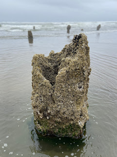
However the trees ended up in the surf, it's an eerie sight. Barnacles coat some of the stumps rendering them as like giant mushrooms emerging from the surf. Other stumps contain mini-tide pools full of creatures echoing what we saw days earlier in the Cape Kiwanda tide pools.

Neskowin Ghost Forest - Sitka spruce stump with barnacles.Neskowin Ghost Forest - Sitka spruce stump with barnacles.Neskowin Ghost Forest - Sitka spruce stump with barnacles.Neskowin Ghost Forest - Sitka spruce stump with mini-tide pool.Neskowin Ghost Forest - Sitka spruce stumps in the surf.Neskowin Ghost Forest - with Proposal Rock in the distance.
Photos of the Neskowin Ghost Forest.


World of salt

Later in our Neskowin Farmers Market day, we drive north to visit Nevør Shellfish Farm and Jacobsen Salt Co. At Nevør, Pacific oysters (Magallena gigas), an introduced species from Japan, are on the menu. The Pacific oyster was imported in the 1930s to save the West Coast oyster industry after the native Olympia oyster (Ostrea lurida) was nearly wiped out. The Pacific oyster is the main oyster used today worldwide, from France to China.

The different types of Pacific oysters can be chalked up to cultivation and merroir – terroir for oysters. At Nevør the oysters we buy are named Petite Tørkes and reflect merroir of the Netarts Bay where they are cultivated. The Oysterater site says of oysters, "[t]hey are as close as you can come to eating the sea and getting away with it" and in this case we are eating the sea of the bay we glimpse through the trees as we snack on barbequed oysters, sitting at a picnic table.

If oysters are a metaphorical sip of the sea, then Jacobsen salts are a sprinkle of the sea on your food. Water from Netarts Bay is a good starting point for making salt because of the filtering effect of nearby oyster cultivation like Nevør Shellfish Farm and Netarts Bay Shellfish. Another reason the bay yields good salt is because there are few freshwater sources coming into it, leading to less possible contaminants. The water from Netarts Bay goes through three stages to become salt: a reverse osmosis machine converting seawater to prebrine, a boiling process converting prebrine to brine, and an evaporation process converting brine to final product.

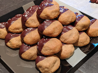
A few days later, we make peanut butter cookies, dip them in chocolate, and finish them with a sprinkle of Jacobsen salt. Netarts Bay for dessert.

Barbequed oysters at Nevør Shellfish Farm.Nevør Shellfish Farm menu.Nevør Shellfish Farm shucked Petite Tørkes oysters.Jacobsen Salt Company - vats boiling down seawaterJacobsen Salt Company flake salt on peanut butter cookies.
Left: Barbequed oysters at Nevør. Center left: The menu at Nevør. Center: Shucked Nevør Petite Tørkes oysters. Center right: Boiling tanks at Jacobsen Salt Co. Right: Jacobsen Salt Company flake salt on peanut butter cookies.


Sedges have edges

During our time in Pacific City, we also visit Sitka Sedge Natural Area, an estuary and large beach. Our very first question after stepping out of the car: is this really named after a sedge? The answer is yes! The area is named after Water Sedge or Leafy Tussock Sedge, Carex aquatilis, which grows natively in the natural area. In Pacific City, we also spot Large Headed Sedge (Carex macrocephala) mixed in with dune grass.

All this talk of sedges recalls the gardening rhyme: "Sedges have edges, rushes are round, grasses have knees that bend to the ground". We use this rhyme to explain the difference between the different species: Cyperaceae, Juncaceae, and Poaceae, respectively. Our friends have never heard the rhyme and tease us but won't soon forget the difference. To clarify: the knees of grass are "joint-like nodes found along round, hollow stems. The stems of sedges and rushes are solid; in cross-section the stems of rushes are round, while those of sedges are triangular and so have edges."

At Sitka Sedge, we start in a parking lot just off the road and walk along a tra­il with Sand Lake on our right and Reneke Creek and marsh area to our left. Where there are wooded areas we are under Sitka spruce (Picea sitchensis) with Salmonberry (Rubus spectabilis), Swordfern (Polystichum munitum), and Treacleberry (Maianthemum racemosum) as groundcover. When we are in full sun, we are shoulder to shoulder with thickets of Rose spirea (Spirea douglasii), Twinberry (Lonicera involucrata), Red Elderberry (Sambucus racemosa), and native roses. As we near the beach, the ground becomes sandy and it's Shore Pine (Pinus contorta) and Kinnikinnick (Arctostaphylos uva-ursi).

Anoher afternoon in Pacific City, instead of walking up to the dune to the sea, we instead head inland on foot to a wooded forest. We walk into a temperate coastal rain forest. On our way up the small hill, we encounter a mother deer with fawn. We crouch, and the doe and fawn pick their way around us, walking through stands of Tall Scouring-rush (Equisetum hyemale). The gardening rhyme needs an addition for horsetails: "Sedges have edges, rushes are round, grasses have knees that bend to the ground, and horsetails nobody wants around"?

After a short climb we are at an observation point, about 262 feet above sea level, in a sliver of the Siuslaw National Forest. A clearing through the trees reveals a perfectly framed Haystack Rock, our orientation point.

A rundown of other plants we encountered during our stay in Pacific City, ordered by family, include:

Adoxaceae - Sambucus racemosa - "Red Elderberry"
Asparagaceae - Maianthemum dilatatum – "Snakeberry", "Two-leaved Solomon's Seal"
Asteraceae - Tanacetum camphoratum - "Dune tansy"
Asteraceae - Achillea millefolium - "Yarrow"
Brassicaceae - Cakile maritima – "Sea rocket"
Convolvulaceae - Ipomoea pes-caprae - "Beach morning glory"
Fabaceae – Lathyrus japanicus – "Beach Pea"
Fabaceae - Lupine littoralis - "Seashore lupine"
Melanthiaceae - Trillium ovatum - "Western trillium"
Nyctaginaceae - Abronia latifolia - "Yellow sandverbena"
Orchidaceae – Goodyera oblongifolia – "Westerna Rattlesnake Plantain"
Pinaceae - Pinus contorta - "Beach pine", "Shore pine"


Caprifoliaceae - Lonicera involucrata - Twinberry honeysuckleAsparagaceae - Maianthemum dilatatum – Snakeberry, Two-leaved Solomon's SealOrchidaceae – Goodyera oblongifolia – Westerna Rattlesnake PlantainPinaceae - Pinus contorta - Beach pine, Shore pineRosaceae - Spirea douglasii – Rose spirea

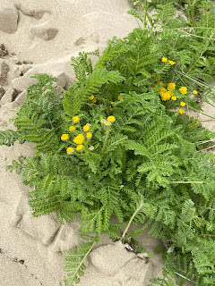
Asteraceae - Achillea millefolium - YarrowAsteraceae - Tanacetum camphoratum - Dune tansy plantAsteraceae - Tanacetum camphoratum - Dune tansyBrassicaceae - Cakile maritima – Sea rocketConvolvulaceae - Ipomoea pes-caprae - Beach morning glory

Poaceea - Ammophila breviligulata - Dune GrassCyperaceae - Carex macrocephala - Large headed sedgeFabaceae - Lupine littoralis - Seashore lupineFabaceae – Lathyrus japanicus – Beach PeaFabaceae - Lupine littoralis - Seashore lupine
Photos of plants observed in and round Pacific City, Oregon.


Chance upon a dory

Reviewing our photos of our time in Pacific City, we find many show wet sand creating a warbled mirror of the sky and objects in the horizon, be they Cape Kiwanda or Proposal Rock. (Reflective beach has an entirely different meaning as described here.) The effect reminds of us our Northwest hikes and the reflectivity in alpine lakes.


Beach reflections in Pacific City, Neskowin, and Tierra Del Mar Oregon.

On the south, protected side of Cape Kiwanda, the wet sand mirrors the cape and its dunes. The placid mirrors are interrupted every so often by a dory charging into shore. Keep your wits about you in this area. If you hear an air horn, it means a dory is incoming. Get out of the way.

The dory pilots must land their boats on the sand by sliding up on to the beach. To do that, they gun the engines while still in the surf, blowing the horns to scatter surfers and warn people on the beach. At some point close to shore, the engines are cut, and the boats glide up the beach. The sand is the brake.

Pacific City dories have a unique history in this area with no dock, port or marina. It's one of the few places in the world where the beach is used to launch and land boats. The dory's flat bottom is the key. For more information, see this Oregon Field Guide video: Dory Builder.

One evening we play Farkle and Golf, games of chance. We pick the player names: Circuit and Phantom Music. Our friends choose: Kwazimabababa and Design Schlong. Life is about chance. Chance encounters years earlier result in us playing Farkle and Golf with Kwazimabababa and Design Schlong on the Oregon Coast.

Since 1854, there have been 21 tsunamis that have reached the Oregon coast. Staying in Pacific City, we couldn't help but notice tsunami evacuation maps, signs, and sirens. Upon arriving, Kwazimbababa and Design Schlong, like seasoned flight attendants, inform us of our evacuation route, pointing our way to higher ground. Such wonderful and knowledgeable hosts!

Tsunamis are most commonly caused by large earthquakes under the ocean, such as ones from the Cascadia Subduction Zone, which lies about 70 – 100 miles off shore. An earthquake in this fault is why the Neskowin Ghost Forest pokes out of the surf today and not soil.

There are two types of tsunamis, distant and local. Distant tsunamis will generally cause warning systems to go off and you'll have time (up to hours) to evacuate. With local tsunamis such as from the Cascadia fault: the earthquake may be your only warning. In this case, after riding out the quake (drop, cover, hold on), immediately head to higher ground. Don't leave it to chance.
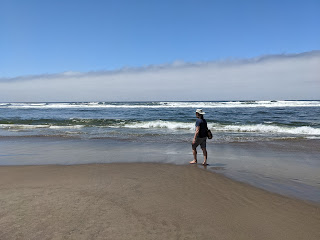
Walking on the beach near Pacific City Oregon, what you shouldn't do after an earthquake or after hearing a tsunami warning.A tsunami evacuation plan in Neskowin.Informational sign describing the history of the Pacific City dory.A sign showing sea life to be spotted at Cape Kiwanda.Map of Sitka Sedge Natural Area.
Left: Walking on the beach near Pacific City Oregon, what you shouldn't do after an earthquake or after hearing a tsunami warning. Center left: A tsunami evacuation plan in Neskowin. Center: Informational sign describing the history of the Pacific City dory. Center right: A sign showing sea life to be spotted at Cape Kiwanda. Right: Map of Sitka Sedge Natural Area.

Coda: song to a siren


Our time in Pacific City comes to a close but it's more than just the end of a simple vacation. It's a coda to our month in the Northwest after being away for so long, and especially after the pandemic. 

In Pacific City, we wandered between dunes and forest, tasted and felt salt and sand, looked for agates and ghost trees in the surf, and silently wondered about our future. A question we heard  many times rattles around in our heads: "What are your plans?".

Climbing the Cape Kiwanda sand dunes one cloudless day, we inch our way to the top, stopping every few feet to rest. We can't decide whether to go barefoot to sink deep in the hot sand or wear sandals to avoid the heat. Sandals go on and come off several times. We are with friends and the talk turns to uncertainty and future plans. They too – we discover – are often asked about their plans and they don't know either. It is not unique to us. Collectively, we arrive at a realization that it's okay to say "We don't know". We sail on a journey with no particular destination.

The "Song to the Siren" written by Tim Buckley and Larry Beckett is a fitting coda. Here are This Mortal Coil's version and Amen Dunes' version of the song, which starts like this:
Long afloat on shipless oceans
I did all my best to smile
'til your singing eyes and fingers
Drew me loving to your isle.
And you sang
Sail to me,
Sail to me, let me enfold you

Maybe we are waiting for an isle to appear to know where to sail to. Or, maybe it will never appear. 

A view of Haystack Rock from a dune in Pacific City.Horse riders on Pacific City Beach, Oregon.Riding bikes on the beach in Pacific City Oregon.A forest path and a fawn in Pacific City.A path in Sitka Sedge Natural Area.
Views along paths. Path over a dune, tracks and horses on a the beach, bike riding, forest paths.

Botanizing in the crevices of the dunes of Cape Kiwanda.Climbin the Cape Kiwanda Dune from the south side.View of the head of Cape Kiwanda.View of part of Cape Kiwanda from tide pools.
Cape Kiwanda. Left: Botanizing in the crevices of the dunes. Center left: Climbing the dune from the south side. Center right: View of Cape Kiwanda. Right: View from tide pools to cape.

Fourth of July celebrations on the beach in Pacific City.Fourth of July celebrations on the beach in Pacific City - with Haystack Rock in the distance.Fourth of July celebrations on the beach in Pacific City.Fourth of July celebrations on the beach in Pacific City.
View of Fourth of July celebrations on Pacific City beach.