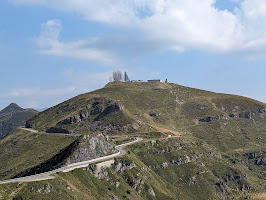
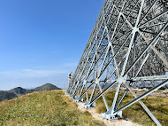
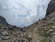
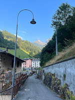
Top row - left: Approaching the ACE High IDGZ base in Italy.
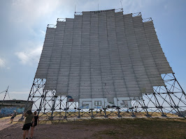
Top row - right: Tropospheric scatter antenna at Dosso dei Galli IDGZ.
Top row - right: Tropospheric scatter antenna at Dosso dei Galli IDGZ.
Bottom row - left: The troposcatter antennas of Dosso dei Galli IDGZ.
We were on our way to a hike (see A Hike to Laghetti di Bruffione) and our friends decided to take us through Passo della Spina (explained below) and then past this ex-radiocommunication station. When they asked if we wanted to get out and see it, we jumped at the chance.
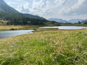
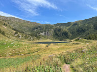
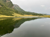
We are in Valle Sabbia, in the Brescia province, in the Brescia and Garda Prealps, part of the larger Southern Rhaetian Alps. The landscape is idyllic, with the mountains and pastures shared alike by cows, goats, walkers, skiers, and bikers. On the day we visit, a local farmer sells cheese at the entrance to the site. It’s in this context that the NATO communication base was constructed in the early 1960s.
Growing up, we’d heard of the “cold war” and NATO (North Atlantic Treaty Organization), but we treated them as abstract concepts belonging to the generation before us. But there are not. Today, “cold war” and NATO come up just as often; they are terms of our generation and subsequent ones. Coming to this abandoned base spurred us to think about these terms and why NATO was created.
The station was part of the Allied Command Europe Highband (ACE High), a NATO radiocommunication and early warning system that was operational between 1965 and 1995. This station is at 2,196 m (7,205 ft) on a mountain in the province of Bergamo. The station was one of a backbone of stations extending from Norway to Turkey.
The system was shut down because newer technologies became available, and the frequency band used in the ACE High needed to be returned to the civilian sector. A good write-up, with beautiful pictures is at One Man, One Map.
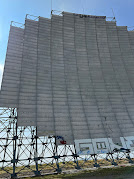
The ACE High system used a method of communication called tropospheric scatter (troposcatter), where radio signals are aimed just above the horizon in the direction of a listening station. Some of the signal passes through the troposphere but some is scattered back toward the earth allowing the receiver to pick it up. Troposcatter antennas have to be large to pick up the signal and focus the beam for sending signals. The size of the antennas at Dosso dei Galli are about 20 m high. The squared-off version of typical parabolic antennas is referred to as a “billboard”, which is what you see at Dosso dei Galli.
One billboard antenna at Dosso dei Galli communicated with Feldberg (Schwarzwald), Germany (AFEZ). The other antenna it says communicated with Livorno – Monte Giogo (IMXZ) and Cavriana – Monte Bosco Scuro (IMBZ).
The name of the hill the abandoned stations occupies is called Dosso dei Galli (location), named for the gallo cedrone that once made their nests there. A gallo cedrone (Tetrao urogallus) is known as a western capercaillie, Eurasian capercaillie, or wood grouse. We did not see any birds while we were visiting. Could it be the fact that the top part of the mountain was removed to create a flat space for the base was not enticing to them? See photos here of before and after. The top 79 m (260 ft) of the mountain was removed.
To get to the station, go to Giogo del Maniva and then continue on to SP345 north to find the station here. These are asphalt roads.
We took a route that was a bit more scenic that involved dirt roads not for cars. From Rifugio Rosa di Baremone, following Via Passo Maniva we went to Giogo del Maniva on an old military route called Passo della Spina. It’s a dirt road, with sheer drop-offs and often not enough space for two cars to pass by normally. (One usually backs up to a place where the two can pass.) You shouldn’t travel this road in a car. We were in a jeep with an experienced driver. There were lots of motorcycles and bikers on the route as well.

Left: At the entrance to the ex-base - a local farmer sells cheese.
Overview
We were on our way to a hike (see A Hike to Laghetti di Bruffione) and our friends decided to take us through Passo della Spina (explained below) and then past this ex-radiocommunication station. When they asked if we wanted to get out and see it, we jumped at the chance.
We are in Valle Sabbia, in the Brescia province, in the Brescia and Garda Prealps, part of the larger Southern Rhaetian Alps. The landscape is idyllic, with the mountains and pastures shared alike by cows, goats, walkers, skiers, and bikers. On the day we visit, a local farmer sells cheese at the entrance to the site. It’s in this context that the NATO communication base was constructed in the early 1960s.
Growing up, we’d heard of the “cold war” and NATO (North Atlantic Treaty Organization), but we treated them as abstract concepts belonging to the generation before us. But there are not. Today, “cold war” and NATO come up just as often; they are terms of our generation and subsequent ones. Coming to this abandoned base spurred us to think about these terms and why NATO was created.
Station
The system was shut down because newer technologies became available, and the frequency band used in the ACE High needed to be returned to the civilian sector. A good write-up, with beautiful pictures is at One Man, One Map.
The ACE High system used a method of communication called tropospheric scatter (troposcatter), where radio signals are aimed just above the horizon in the direction of a listening station. Some of the signal passes through the troposphere but some is scattered back toward the earth allowing the receiver to pick it up. Troposcatter antennas have to be large to pick up the signal and focus the beam for sending signals. The size of the antennas at Dosso dei Galli are about 20 m high. The squared-off version of typical parabolic antennas is referred to as a “billboard”, which is what you see at Dosso dei Galli.
One billboard antenna at Dosso dei Galli communicated with Feldberg (Schwarzwald), Germany (AFEZ). The other antenna it says communicated with Livorno – Monte Giogo (IMXZ) and Cavriana – Monte Bosco Scuro (IMBZ).
Name
Arriving
To get to the station, go to Giogo del Maniva and then continue on to SP345 north to find the station here. These are asphalt roads.
We took a route that was a bit more scenic that involved dirt roads not for cars. From Rifugio Rosa di Baremone, following Via Passo Maniva we went to Giogo del Maniva on an old military route called Passo della Spina. It’s a dirt road, with sheer drop-offs and often not enough space for two cars to pass by normally. (One usually backs up to a place where the two can pass.) You shouldn’t travel this road in a car. We were in a jeep with an experienced driver. There were lots of motorcycles and bikers on the route as well.
Photos


Left: At the entrance to the ex-base - a local farmer sells cheese.
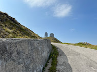
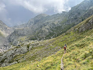
Center: Approaching the IDGZ Dosso dei Galli.
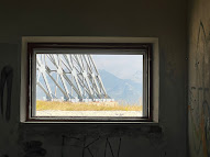
Right: View from a window at Dosso dei Galli IDGZ.
Right: View from a window at Dosso dei Galli IDGZ.
Back of a troposcatter antenna at Dosso dei Galli IDGZ.
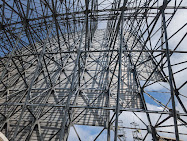
Left: Bottom of troposcatter antenna with humans for scale.
Center: Entering the site Dosso dei Galli IDGZ in Italy.
Right: Tropospheric scatter antenna at Dosso dei Galli IDGZ.


Right: Tropospheric scatter antenna at Dosso dei Galli IDGZ.


Graffiti at ACE High ex-NATO IDGZ station at Dosso dei Galli.

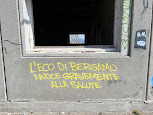

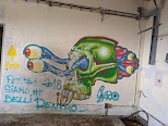
Graffiti at ACE High ex-NATO IDGZ station at Dosso dei Galli. One says "L'Eco di Bergamo nuoce gravemente alla salute" or "The Eco di Bergamo [newspaper] seriously damages your health."


The abandoned buildings at Dosso dei Galli.




Graffiti at ACE High ex-NATO IDGZ station at Dosso dei Galli. One says "L'Eco di Bergamo nuoce gravemente alla salute" or "The Eco di Bergamo [newspaper] seriously damages your health."


The abandoned buildings at Dosso dei Galli.


A troposcatter antenna at Dosso dei Galli, in the province of Brescia Italy.





![Flora - [Caryophyllaceae] Silene dioica - Red campion Flora - [Caryophyllaceae] Silene dioica - Red campion](https://blogger.googleusercontent.com/img/b/R29vZ2xl/AVvXsEgQc4qo-AeXIJbphOm9l8WWwIUPKzdzI8J8TWtJif58pACOqilYKtKY2CXPFlumRq0NYtwMAmx0HYlkJs3I9xdg6PWV5FKL7ae_WzaSWDKKHIlmrkuH8j0sUe0jGhrScrpjZy5ipKO67TIkj92ZaHgzx_fKcovafvh7CZj5Wji4MG0QppZxiabb3dCFjg/w150-h200/Flora%20-%20%5BCaryophyllaceae%5D%20Silene%20dioica%20-%20Red%20campion.JPG)
![Flora - [Coleosporiaceae] Chrysomyxa sp. - Spruce needle rust Flora - [Coleosporiaceae] Chrysomyxa sp. - Spruce needle rust](https://blogger.googleusercontent.com/img/b/R29vZ2xl/AVvXsEiGELGcXWHFl7uqJVhjywicZ3j6Vb6opwoAoUfY7-lb3Zfj1YIbDgEADUmyHU7Nw9-798VqsQTcISVxOG41F4pA6WlpxzKquGuhXvZuj2JYmI_C9HdxICe9jlXBMqK4TspK4c0cFemtPUBqfm91xymaWlU6KwAioxDxSsSSKUh4QTb710_ap_fzu-zJHw/w150-h200/Flora%20-%20%5BColeosporiaceae%5D%20Chrysomyxa%20sp.%20-%20Pine%20rust.JPG)
![Flora - [Gentianaceae] Gentiana asclepiadea - Willow Gentian (Genziana di Esculapio) Flora - [Gentianaceae] Gentiana asclepiadea - Willow Gentian (Genziana di Esculapio)](https://blogger.googleusercontent.com/img/b/R29vZ2xl/AVvXsEh2TlC7e8iKRB5MGrsXH5dSqPm0lGNHSXGWsdYQXEo2A4eQWp-XzMoJNxgouXndtJPYT80i8ByhmIyx6dKNDouWgNi9ZrBImPNBzuQHlpSRTPTHEU-a-kw9Kfd6bYV-EC5LtKNeDRUaMeJPsSsSqiaMietinlPYICDE9tJ1iJXdyh0LaCodJTFln7scbQ/w150-h200/Flora%20-%20%5BGentianaceae%5D%20Gentiana%20asclepiadea%20-%20Willow%20Gentian%20(Genziana%20di%20Esculapio).JPG)
![Flora - [Polygonaceae] Rumex alpinus - Monk's rhubarb Flora - [Polygonaceae] Rumex alpinus - Monk's rhubarb](https://blogger.googleusercontent.com/img/b/R29vZ2xl/AVvXsEgu9z9ydoGsMT-EvpjGUXWgNES5Z6TykZ5dv3AjW4qY4rwiLra3NCvIEQrRYnn-6mBEd9E2chRvI7unZjc7TGqjUAg-hG_POiAsClLhCdhxqEuYJ5JtwmF87vRQUJiQMl4a3A0ObNImC1D5G-w8oTRei9hBh61hrTOpT6fuYOjsEZ5ACLPtBwtbILluGA/w150-h200/Flora%20-%20%5BPolygonaceae%5D%20Rumex%20alpinus%20-%20Monk)






%20of%20Tre%20Signore.JPG)



![[Asteraceae] Adenostyles alpina [Asteraceae] Adenostyles alpina](https://blogger.googleusercontent.com/img/b/R29vZ2xl/AVvXsEjH9wK4_Rn2DXaPUXnXiKgi-PUYJbvVzUwuEuRLoDeNMFhDn_3lFj1aHn3G3afnciCCNNgdifSjPjV3QgxCyJmj8oVr3mKiFdv0dG0yv1oiAJlmeCQP14rgKWH9w-VP46CrIs__FLHq7QdO7lFcwWVRafG3VNmgI5eaqaF7a5cM6Sh13K6chtQJ2fVJGg/w150-h200/%5BAsteraceae%5D%20Adenostyles%20alpina.JPG)
![[Asteraceae] Carlina acaulis [Asteraceae] Carlina acaulis](https://blogger.googleusercontent.com/img/b/R29vZ2xl/AVvXsEiHQi2wJ184q3Jx3jVPXISQi-5zOYv7_pTp1kG0LgPJrw1R583rPj29qSyf03SGSXz90_SqN0hIKBWt5JnCxH3Cea3BYDmSxNS9h-v0F0WPYsUFvv3gmQVVQFhSNoV7h9v2W-3XImje4CTkqdoaGy--pxGc7oSvNs-NmiVgDCnYbe9W5z5VN9JQCi4DwA/w150-h200/%5BAsteraceae%5D%20Carlina%20acaulis.JPG)
![[Celastraceae] Parnassia palustris [Celastraceae] Parnassia palustris](https://blogger.googleusercontent.com/img/b/R29vZ2xl/AVvXsEgZdjqt82VSjcMwBCfIlu9RZZD9JHdoqOsOOkOwzllN8DPT7RXFxsh9yMJSZTcphSjtKTOcRsueqUZjZ7E10c1SsNtIR3EMp4IH_DXSW4Of1f_qarcirLL_fUo4E_3PD84NC2mt13Q_9Ik8QC2Gpbx5lsvz3eR2WO6DNB5RQ5UuCRDHOcbu1ipHHIbplA/w150-h200/%5BCeleastraceae%5D%20Parnassia%20palustris.JPG)
![[Ericaceae] Calluna vulgaris [Ericaceae] Calluna vulgaris](https://blogger.googleusercontent.com/img/b/R29vZ2xl/AVvXsEh7qnmNikVteF60OwTF5RZKw0ChVqrN2khdx_Aovl_6cx92CFncMzvl7tJv8R11yB5Ftp8mUZwBufug0b8Tr0zEn6mTb_8lltE5Skmy5vS1j9hIZOmxkMBGzS4ytGlrAFmUk4SK_A4MY4fEhH5bw90kbNIHDiz_du6kloBnbnWbe40CLCJ3wD5UiuC1Ww/w200-h150/%5BEricaceae%5D%20Calluna%20vulgaris.JPG)
![[Getianaceae] Gentianella sp. [Getianaceae] Gentianella sp.](https://blogger.googleusercontent.com/img/b/R29vZ2xl/AVvXsEiED-oZNHdCJnpRezTOXNM8csPsuywSEy6jDvNI-o2KHQI0vEMmIFYFNtF7NCQZ4RvsyHAaRoWlXObfjCbIbEidy7msOwonRnPkhXS7zHG05lu-dUAgdazyqLJo_1xVTlWdyHlrEYADsN_ibp9WrgT7rrDos_GpYNdVSv341pX2SqS7__7-tdqH8lyxBw/w150-h200/%5BGetianaceae%5D%20Gentianella%20sp..JPG)
![[Orobanchaceae] Eurphrasia sp. [Orobanchaceae] Eurphrasia sp.](https://blogger.googleusercontent.com/img/b/R29vZ2xl/AVvXsEhmL0Stsk5CGT7852Ekp2QLB0lHvmLGkDL_uk5Vr5pFKqmKclHHV5y80AifPZhkgH_l0iPySRcJXlJ6mFPIAKbbhrIwCNUte1Qsf6ZEtPbTfaY_rWO6H7sWe0-c6yFRkViAHsxr1KzZYLvMqKr-1tYds5cDJ8jHalOgXgGkYu0znlGi9XAsnyQ_f35CnA/w150-h200/%5BOrobanchaceae%5D%20Eurphrasia%20sp..JPG)
![[Papaveraceae] Pseudofumaria lutea [Papaveraceae] Pseudofumaria lutea](https://blogger.googleusercontent.com/img/b/R29vZ2xl/AVvXsEjU8ji1zySZ-54NCiw1vBqzikcSmC6SdOQSjUveyOEPEoQCC1cwpYfEg22M-ul3xR2DVZQikjhKlCoJnKC0XeZ-tsVqHJBTm1nIz1c-SU_JDL6kUTyNbGjjEcfUzDTkWrcEwwHulmBb0OkSGQvvtYyglp9Fi6DzkPPC9uig8eIdXyjtSMzhsa7L2DpJ-Q/w150-h200/%5BPapaveraceae%5D%20Pseudofumaria%20lutea.JPG)
![[Polygonaceae] Oxyria digyna [Polygonaceae] Oxyria digyna](https://blogger.googleusercontent.com/img/b/R29vZ2xl/AVvXsEgGf0Vv0_mUZ2DHScEt3h55SqWdrE3IthMJLg9lEo2hoIVgAn9Y3ww67xFAtzVojVsypvZg4kGFtM8fzPi165NS6ytbeJU5BqGfdDttVLKXiKifh-0yuHmGRSd2QjUlo2u5NlQfsdyNni4uCDymE6g1QnxJtVMHOE6bXv2JjBtuUK5YL3MQThCo1IhVgg/w150-h200/%5BPolygonaceae%5D%20Oxyria%20digyna.JPG)
![[Pteridaceae] Cryptogramma crispa [Pteridaceae] Cryptogramma crispa](https://blogger.googleusercontent.com/img/b/R29vZ2xl/AVvXsEhozoqltNwoLwvYNmF7iTvHJSJWf9DSoExrqn27M--zo2R6vKYl4GBmgiKLSxRuqMKQTrEmF8aUtgVm6Sythd0sfQBNW7UpUbPuYmW3RHrD7mTONC5ie8u97eLXZmqf0kTGH0YzKvM67RTItGMGzoRtjI2XO3P7qxrxhWVsj_8FsCtDWe6zCViy7jNonQ/w200-h150/%5BPteridaceae%5D%20Cryptogramma%20crispa.JPG)
![[Ranunculaceae] Aconitum lycoctonum [Ranunculaceae] Aconitum lycoctonum](https://blogger.googleusercontent.com/img/b/R29vZ2xl/AVvXsEi6P_4m3WQpDy7-bu6N70sCzCe-7miixcCGysan7_vWrykxwqBn8hiem6kKDSgiJk3SleyI9sO9EhJzlOUqiFUnKKkH6djVyLdtSt1l-TgUbIHCd_JM4qwoKHvrgx3h5aknunZxoSyRPTuC7e_NChJuRXTVsyreWeMAgK8NKu2uBYp_UE0gRObRhmHkoQ/w150-h200/%5BRanunculaceae%5D%20Aconitum%20lycoctonum%202.JPG)
![[Ranunculaceae] Aconitum lycoctonum [Ranunculaceae] Aconitum lycoctonum](https://blogger.googleusercontent.com/img/b/R29vZ2xl/AVvXsEgZU1jH36bJhE6EXYOAxMKDs9q3trk11SvQv-ohV--3tBTndbYRFv-s1FispXdcUiUwvyiAnl1btaaBnn8_hRNWQfj2PkdqMISq5IzUYvdekFyLrFbysm9venaDE-4Hf7MzcKRAiAmbbd4PBhGH1FO_WJVYBoArjkQcoNQssDc489ph152mqtLikzzuPw/w150-h200/%5BRanunculaceae%5D%20Aconitum%20lycoctonum%201.JPG)
![[Ranunculaceae] Aconitum napellus [Ranunculaceae] Aconitum napellus](https://blogger.googleusercontent.com/img/b/R29vZ2xl/AVvXsEgIJwQNdT6f86DuvaJodrPdXu_vNrZMmfFMY2sQujVMteAkh6QOJhsdX6Q1T5ltmcvLYD76ypwyB82lqhNz5n5ABYREYdU8z1gjEv4taRgB4kZJqnFI1hS8WjS2raFicy64ehnrvQrUoIcN9DVz9D5TD3U8ZPdEr_3PElT0z9ikpDOVH-LOza-Tyu8gIw/w150-h200/%5BRanunculaceae%5D%20Aconitum%20napellus.JPG)
![[Ranunculaceae] Anemone seed head [Ranunculaceae] Anemone seed head](https://blogger.googleusercontent.com/img/b/R29vZ2xl/AVvXsEgKDB0QI5iPRor-hpoFdNEoxT0_N-G_KJJjAEwe3DlzWI4kPSXiM95h7zfBtFLgkGrfLjOMOed2GWqvIud1xZsm9-KLDRtamnOlrziTiNqJGOQ2LnPw3-0cKB4h35jYKoFY2OQzTqJjVyw-Uf8FRJIX5GDYJoWHvLEK9NmgoKQyx301TuPUbH9wQ2_MpA/w150-h200/%5BRanunculaceae%5D%20Anemone%20seed%20head.JPG)
![[Rosaceae] Potentilla nitida [Rosaceae] Potentilla nitida](https://blogger.googleusercontent.com/img/b/R29vZ2xl/AVvXsEi0xFSIimAmKk6ppHdJPt1SFJrftb43vyLZZDxQMKRoChuLLTZtJCupSx8sKziam8EszcsUxAErWyODxj5rDdCM550rlXO6KuJPSQmHRoBF2VvjWAPlGQl6gvMfaKruVLgI1HJN4cMle1LASaQRrWCrtrQ1Hi1cu5bVlmAQcna_JN4n30yDLPaGfyJvFw/w150-h200/%5BRosaceae%5D%20Potentilla%20nitida.JPG)
.JPG)






%20-%20Valle%20dell)
%20-%20Valle%20dell)
%20from%20below.JPG)





%20in%20Valle%20dell)