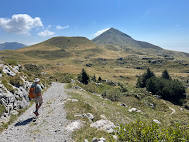
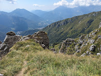
Left: Starting out the hike in Piani di Artavaggio with Monte Sodadura in the distance.
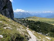
Center: On Trail 101_b above Piani di Bobbi.
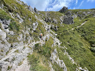
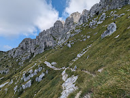
Right: The trail called "Sentiero degli stradini" connecting Piani di Bobbio with Piani di Artavaggio.
Center: On Trail 101_b above Piani di Bobbi.
Right: The trail called "Sentiero degli stradini" connecting Piani di Bobbio with Piani di Artavaggio.
Overview
Elevation: 567 m gain
Length: 14.3 km
Location: Italy, Lecco Province, Valsassina
The location of this hike is Valsassina, a valley east of Lago Como, and about one hour away from Bergamo by car. On the east side of this valley there are two high pasture areas called Piani di Artavaggio and Piani di Bobbio, both areas running between 1600 m and 2000 m.
Piani di Bobbio means the “pastures of Bobbio”. In the early Middle Ages, these pastures were owned by the Abbey of San Colombano di Bobbio, in the province of Piacenza, hence the current name. Of the name “Artavaggio”, we could not find any news. It seems like a made-up name.
You can reach Piani di Artavaggio with the funivia (cable car) in Moggio at (900 m), which is how we arrived.
The absolute worst day to go is on Ferragosto (August 15), when we went. Should have known! Despite searching for parking for 20 minutes and finding something a kilometer away from the cable car, we managed to make it up to the “piani” and start our walk without too much trouble. The Milanese and Lecchese that frequent these alpine pastures tend to find a spot in the sun and camp out for this holiday. On the trails we saw few hikers.
Our hike was a roundtrip walk between Piani di Artavaggio and Piani di Bobbio heading out on Sentiero 101_b and coming back on Sentiero degli Stradini. Sentiero 101 b is part of the Sentiero delle Orobie occidentale (west). Back in 2018, we did the Sentiero delle Orobie orientale (east) - see Seven Days on the Sentiero delle Orobie - A Journey Throught the Bergamo Alps.
The Senteiro degli Stradini had some exposed parts where cables were attached and were VERY much needed. We took this trail back to Piani di Artavaggio to avoid following 101_b back and see different scenery.
This being Ferragosto, the rifugi were hopping. Mid-morning, we stopped at Rifugio Nicola for a coffee and snack, and then started on 101_b toward Piani di Bobbio. We had planned to eat at Rifugio Lecco (Piani di Bobbio) but it was so busy, that we kept walking and returned to Piani di Artavaggio to eat at Rifugio Casari.
Plants
[Rosaceae] Rubus saxatilis
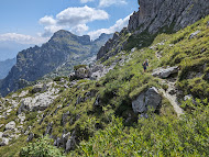


Left: On Trail 101_b on the west side of Zucco Barbesino.
Left: Sentiero degli stradini.
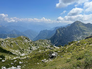
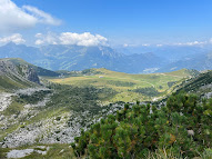
Center and right: The trail from Bocchetta dei Mughi to Rifugio Lecco - trail 101_b 2.


Left: Tracks showing the route taken.
Center: Trail 101_b under the Bocchetta dei Mughi.
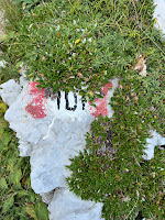
Left: A trail marker for 101.

![[Asteraceae] Adenostyles sp [Asteraceae] Adenostyles sp](https://blogger.googleusercontent.com/img/b/R29vZ2xl/AVvXsEgRQlineUK6P6ZhzcBtsawMtj01MSGMXlpXcJcz2wit1xqiPDSS8uFHuUWnhtTinS1U5mhVlXhYehGPO_wbW4yXSGf6MrTHl-zhmP6IW9UUCeTCn6PACg5w9M2N9_hqLhsX1v2CRnz2nwqZzgsrdbWOeIliA4cG53OQR_l7SWo7LuATS6Hc2_7Vmyjz3g/w200-h150/%5BAsteraceae%5D%20Adenostyles%20sp.jpg)
![[Asteracease] Rhaponticum scariosum [Asteracease] Rhaponticum scariosum](https://blogger.googleusercontent.com/img/b/R29vZ2xl/AVvXsEjX3t_2L92vJSL__fRE-kodUv1is9N8qpzrCF-TqEgZqPjaWZMsQGnNMB4exD_rgr1dG8atlu_KkGECbvJ0LmQjTjUyPiFFeyjjnyxJxbuDP-c19StTNJRqZaDRqC2gKO2ttCe-6QMU-hyq5PWjqhPpem_M2KdS4sLWJt9_sLhSqPf406yCfGPz74ElKw/w150-h200/%5BAsteracease%5D%20Rhaponticum%20scariosum.JPG)
![[Rosaceae] Rubus saxatilis [Rosaceae] Rubus saxatilis](https://blogger.googleusercontent.com/img/b/R29vZ2xl/AVvXsEhXcyFa67lK_lgfNIbSsT7eBSgjEJKfJHiEok2-jAJhsPL2QMqSUdMhTAkHJQR4iA-9xiyTEfo6sComg5YLZ82QfaFjQOHXEvxXbQJRABpMElMlXnYYIcvZdIKJIJqZ4h02W_eMHLya93-Z1XrRZosP7pSkGmI8XOfJeT_XbdRpNGLiJTeAn6oloLY6PQ/w200-h150/%5BRosaceae%5D%20Rubus%20saxatilis.JPG)
![[Rosaceae] Sorbus chamaemespilus [Rosaceae] Sorbus chamaemespilus](https://blogger.googleusercontent.com/img/b/R29vZ2xl/AVvXsEjCDrjp-XIiAnwC03PVew9g8XpW_AEujYzFzrzfXCmSejXCJb0LUu0HC6zyiNZbpmGmJfh5FB0fngwg_meyH8DSgqLSjkcUMOcJ9LryHkxDqC9DZXS6cvnOKBxvO7PM38cog10oQZDYhEGby3db3f0jeqRVuHuNe6OOsbIXmZsNe6gWZPDHguBdfk7o0A/w150-h200/%5BRosaceae%5D%20Sorbus%20chamaemespilu.JPG)




No comments:
Post a Comment
All comments are moderated. If your comment doesn't appear right away, it was likely accepted. Check back in a day if you asked a question.