

Left: The two flat plains of the Valle di Preda Rossa, a lateral valley of Val Masino, Italy.
Right: The trail climbing to Rifugio Cesare Ponti.
Overview
Duration: 7 hours (roundtrip, a long lunch and several hands of the card game Machiavelli)
Elevation: 629 m (about 2060 ft)
Length: 9.9 km
Location: Val Masino, Sondrio, Italy
A friend asked us to come on a hike in Val di Mello and he said: it will be flat and easy. Well, it was none of these things. The hike was in the adjacent valley, Valle di Predarossa, and the hike was anything but flat with a 629 m (2060 ft) gain. Aside from the surprises, the hike was very fun, with spectacular scenery and a nice lunch at Rifugio Cesare Ponti at 2,559 m (8,400 ft). What’s not to like about that?
The Val Masino area is in the province of Sondrio, in the Lombardy region. Sondrio is the region north of the Bergamo region. Val Masino is a north-south running valley north of Ardenno (just east of Morbegno). Driving north in Val Masino, you reach Cataeggio and then go east. You’ll need a tourist pass (12 euro/vehicle) to drive all the way to the final parking lot called Parcheggio Preda Rossa. The parking lot is at 1955 m. For more information on the pass, see the Val Masino site.
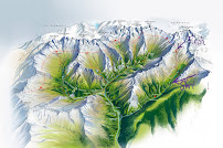
On your way up, you come across two flat, plains. The stream Torrente Duino with its blue glacier water zigzags through the plains. After the second plain (Piano Superiore di Preda Rossa), we followed a path on our left to immediately start climbing to reach Rifugio Cesare Ponti. On our way back we walked the crest of the glacier’s moraine to come back a different way.
The Predarossa glacier is on the south side of Monte Disgrazia and has an area of 110 ha. (data from 1990). Compare that to the recent visit to Presena Glacier with its current 25 ha. We didn’t get close the glacier this time around and we aren’t sure how close you can or should get.
Walking east toward Rifugio Ponti with Monte Disgrazia ahead, you'll notice on your right, reddish mountains and on your left, grayish mountains. The reddish mountains ("pietra rossa" hence "preda rossa") are serpentine and the gray mountains granite.
Flora
Plants and fungi observed:
[Family]Genus species
[Betulaceae] Alnus alnobetula
![[Betulaceae] Alnus alnobetula [Betulaceae] Alnus alnobetula](https://blogger.googleusercontent.com/img/b/R29vZ2xl/AVvXsEgkXodxNmAcW_CimoqsuBmbLfZ8VdEyBFUxPmZePW9koL4XiGxM7YR5YzTjglTwYos8xeN36MAJzSpcffJ3zQ39BC0-6u6jKiammuV5bKi4Bam3nhBvGHw_1K59wdzM3d3pRO8gFtjY6bKXbm-YuAEfGAdnNrNgX5ISAKqI1WGH_9gEeXRRUwm0nxNfLA/w150-h200/%5BBetulaceae%5D%20Alnus%20alnobetula.JPG)
[Caryophyllaceae] Cerastium alpinum
![[Caryophyllaceae] Cerastium alpinum [Caryophyllaceae] Cerastium alpinum](https://blogger.googleusercontent.com/img/b/R29vZ2xl/AVvXsEhRgyJURN3RefidraNeVwd7WaNt94y8hjaYiOMlzg0rCxyMvEI7Zv_hcMLecY6jUWr-qI_5QM4I6rtnE8hYKKrfWwXO5MGrKekFihIB3DjfA9LdBKko6Io6j6k2plZRRqLypLgxf2UIBgKAG9haGOcuFqKeqeuXlbTSNh1QpGqVqmBAdjtTAPMIF4M4WQ/w200-h150/%5BCaryophyllaceae%5D%20Cerastium%20alpinum.JPG)
[Caryophyllacease] Silene acaulis
![[Caryophyllacease] Silene acaulis [Caryophyllacease] Silene acaulis](https://blogger.googleusercontent.com/img/b/R29vZ2xl/AVvXsEhpiZu-0M4oIN0oiFYdxJJ7F6puDTrn3Q468uWvXZMHy_TlLrdN7SUqN3DqGsz78g8TO9qAnYpdiDSoMmU3cPmapBHszDf9PQJh4iugV90NPzphRZhTEVDjKqWH9HCtZ3OEA3uWL2_cR2FKJhk_poq_bk_iMlM7aSYqtdq06e_pAVBatcipQKIgH7HEzA/w150-h200/%5BCaryophyllacease%5D%20Silene%20acaulis.JPG)
[Crassulaceae] Sempervivum
![[Crassulaceae] Sempervivum [Crassulaceae] Sempervivum](https://blogger.googleusercontent.com/img/b/R29vZ2xl/AVvXsEjbshcCHUO9g8ASKX9t68L6dEWLZb5o6YNfYmAU3k44x09LkpHTyQ9g6b6igS0ns4FFhPsAnjBbuONtszKAebhgdW4cBYYHlvTq2wUoO44FqDNN1Ubjwk0fzEnIkfogKzHno2meY7bMDAvBPs5UWO0Xjvx-hWPEH3MdfpkXeTdzyXhMP0tunUCmU5uTVQ/w200-h151/%5BCrassulaceae%5D%20Semperivum.jpg)
[Gentianaceae] Gentianella
![[Gentianaceae] Gentianella [Gentianaceae] Gentianella](https://blogger.googleusercontent.com/img/b/R29vZ2xl/AVvXsEiaCn5_4pMgxSpVxX32gF2oD9CySo7KB-EYFwUsXABLDPvbzvwbU_Ex6GzSqOis_3tEqq1kbjPd9uUDc7vBUlnxjBbWS2aI7VPWSXvd6hppd2heUaQwOLXr0oI_HewJlTZlcyCRYQxzQiSuQT9jnr7kWvm-ap77MG1gcb-8MjXeO8glanQ_1lfLVNbFDQ/w151-h200/%5BGentianaceae%5D%20Gentianella.jpg)
[Juncaceae] Juncus
![[Juncaceae] Juncus [Juncaceae] Juncus](https://blogger.googleusercontent.com/img/b/R29vZ2xl/AVvXsEg-vzlLIaL4jiPkC-utHGufy__eQzm5nKNDwecsJ7bfmgFAh5QG-cSHDwTdr0e_5mhAkbh_UdO7fOu1virPZZWOfxAZWZy1BCYc8pX1FjF2z6a5K695YOFRhms348cq-otbndUqLYU5xyLineM6Tk9_RkqY3QVE9lYoZlEeUr4b9DbMX-eDnxBUJcOkHg/w150-h200/%5BJuncaceae%5D%20Juncus.JPG)
[Melanthiaceae] Veratrum album
![[Melanthiaceae] Veratrum album [Melanthiaceae] Veratrum album](https://blogger.googleusercontent.com/img/b/R29vZ2xl/AVvXsEgsVkF-FsbUoE4cpwB_-jBtn5mSjBFcHd2pz7uzOQT6ZriIePsJx4CQT7xHy8aLcc4TvyZrrvtuQhotnjdgVOyoEUjPkwYJyetv_m-_PPW7ir3u4YhlDGfydxqoZzdyi-Dfa9ByT_pzS7DKpOfrfeghQFiU28Ko5rse1D-ak_ojAeCzdwy6jNekGKCFfQ/w150-h200/%5BMelanthiaceae%5D%20Veratrum%20album.JPG)
[Onagraceae] Epilobium dodonaei
![[Onagraceae] Epilobium dodonaei [Onagraceae] Epilobium dodonaei](https://blogger.googleusercontent.com/img/b/R29vZ2xl/AVvXsEhcSvLhpokxTK4u53m3p4lnF42D0LKfB2n0FbG9oHcHeoS63vd_Qp7o6n27XfnA-LH-5SkuiNQPNltZpUav6oj_fWRwNQjPPKhbAZ5nJ_aykedRFPunCTqNxHlgbd9pAKv8Zqfnjggd--MxrgZaGlZIRG_p_eHz_LWVzNRSZJ9bJLzarbD7FJ-TUHlfgQ/w150-h200/%5BOnagraceae%5D%20Epilobium%20dodonaei.JPG)
[Orchidaceae] Dactylorhiza maculata
![[Orchidaceae] Dactylorhiza maculata [Orchidaceae] Dactylorhiza maculata](https://blogger.googleusercontent.com/img/b/R29vZ2xl/AVvXsEhdg5ZBlxBIbeU1WhObHqf0DBFXp8kQXl_ltfhnvZO56Vkl-fU3gZMYhI9TyUQdV0nwEqAhqsp0Dn_SlDyU1-a9_6TftJTC4U4gHzq_OZP_w99yEeovjmpaKTeg4KFcw0V5cB_XbLal0cLlqv69X4vGjkGld3DpAUmnJNDrPBzIr8WHyiiQcHAbs4jZCg/w150-h200/%5BOrchidaceae%5D%20Dactylorhiza%20maculata.JPG)
[Plumbaginaceae] Armeria alpina
![[Plumbaginaceae] Armeria alpina [Plumbaginaceae] Armeria alpina](https://blogger.googleusercontent.com/img/b/R29vZ2xl/AVvXsEj8zsgC8IkhwuXI8pNhgErGqLDVaAWRScR4dS91ZB9w6G0B25H8ZlRGTKzRrzJaFPWvk9ssppgEX2iv6fy80ZOgHhEtKbU-EHa24a2HIElB2_q4ny5Q_M3KuDTXRWx2eGwtUApbJLN5rz40v2jCBEzAo0vdynvgx9liOayzqFdhzYXgx1xY9EJAWnkduw/w200-h151/%5BPlumbaginaceae%5D%20Armeria%20alpina.jpg)
[Rhizocarpaceae] Rhizocarpon geographicum
![[Rhizocarpaceae] Rhizocarpon geographicum [Rhizocarpaceae] Rhizocarpon geographicum](https://blogger.googleusercontent.com/img/b/R29vZ2xl/AVvXsEgpjW9etW7K4VRysalzvc89rPCVmnk6rs5lzwEwNAZqPKkvLHtPExY3Lf8J1ifRYe1GprLYfTLn52TxOiCfr5bktPlpfiVrDg-8CEET-rngSAHG_V8rFefpclcxt1XNvJbLyaPzWRtCA_PjbMm26e7wILEfTFIKsF1Zyz43Y-vzeiVx2K_cNjCLj7sRcw/w150-h200/%5BRhizocarpaceae%5D%20Rhizocarpon%20geographicum.JPG)
[Saxifragaceae] Saxifraga aizoides
![[Saxifragaceae] Saxifraga aizoides [Saxifragaceae] Saxifraga aizoides](https://blogger.googleusercontent.com/img/b/R29vZ2xl/AVvXsEgGKL5o8-gSq_uD30MbDNMhT4zWYYHGAdYrkc3ZEFGAZxAR65GCuWGNfUboTQDekEB3-LSJKAqVQ2P_Nch8mKPFHknH0fKEeaYP_rWWQnRISbizgyvglBpHKlnepSwuBKRowSoccPQxFnn0kgn2k3yBBugdbS35zncgWYGJD0KiXCkt7aRxWlZd6Eb6ZQ/w150-h200/%5BSaxifragaceae%5D%20Saxifraga%20aizoides.JPG)


Left: Boardwalks over marshy area
[Family]Genus species
[Betulaceae] Alnus alnobetula
![[Betulaceae] Alnus alnobetula [Betulaceae] Alnus alnobetula](https://blogger.googleusercontent.com/img/b/R29vZ2xl/AVvXsEgkXodxNmAcW_CimoqsuBmbLfZ8VdEyBFUxPmZePW9koL4XiGxM7YR5YzTjglTwYos8xeN36MAJzSpcffJ3zQ39BC0-6u6jKiammuV5bKi4Bam3nhBvGHw_1K59wdzM3d3pRO8gFtjY6bKXbm-YuAEfGAdnNrNgX5ISAKqI1WGH_9gEeXRRUwm0nxNfLA/w150-h200/%5BBetulaceae%5D%20Alnus%20alnobetula.JPG)
[Caryophyllaceae] Cerastium alpinum
![[Caryophyllaceae] Cerastium alpinum [Caryophyllaceae] Cerastium alpinum](https://blogger.googleusercontent.com/img/b/R29vZ2xl/AVvXsEhRgyJURN3RefidraNeVwd7WaNt94y8hjaYiOMlzg0rCxyMvEI7Zv_hcMLecY6jUWr-qI_5QM4I6rtnE8hYKKrfWwXO5MGrKekFihIB3DjfA9LdBKko6Io6j6k2plZRRqLypLgxf2UIBgKAG9haGOcuFqKeqeuXlbTSNh1QpGqVqmBAdjtTAPMIF4M4WQ/w200-h150/%5BCaryophyllaceae%5D%20Cerastium%20alpinum.JPG)
[Caryophyllacease] Silene acaulis
![[Caryophyllacease] Silene acaulis [Caryophyllacease] Silene acaulis](https://blogger.googleusercontent.com/img/b/R29vZ2xl/AVvXsEhpiZu-0M4oIN0oiFYdxJJ7F6puDTrn3Q468uWvXZMHy_TlLrdN7SUqN3DqGsz78g8TO9qAnYpdiDSoMmU3cPmapBHszDf9PQJh4iugV90NPzphRZhTEVDjKqWH9HCtZ3OEA3uWL2_cR2FKJhk_poq_bk_iMlM7aSYqtdq06e_pAVBatcipQKIgH7HEzA/w150-h200/%5BCaryophyllacease%5D%20Silene%20acaulis.JPG)
[Crassulaceae] Sempervivum
![[Crassulaceae] Sempervivum [Crassulaceae] Sempervivum](https://blogger.googleusercontent.com/img/b/R29vZ2xl/AVvXsEjbshcCHUO9g8ASKX9t68L6dEWLZb5o6YNfYmAU3k44x09LkpHTyQ9g6b6igS0ns4FFhPsAnjBbuONtszKAebhgdW4cBYYHlvTq2wUoO44FqDNN1Ubjwk0fzEnIkfogKzHno2meY7bMDAvBPs5UWO0Xjvx-hWPEH3MdfpkXeTdzyXhMP0tunUCmU5uTVQ/w200-h151/%5BCrassulaceae%5D%20Semperivum.jpg)
[Gentianaceae] Gentianella
![[Gentianaceae] Gentianella [Gentianaceae] Gentianella](https://blogger.googleusercontent.com/img/b/R29vZ2xl/AVvXsEiaCn5_4pMgxSpVxX32gF2oD9CySo7KB-EYFwUsXABLDPvbzvwbU_Ex6GzSqOis_3tEqq1kbjPd9uUDc7vBUlnxjBbWS2aI7VPWSXvd6hppd2heUaQwOLXr0oI_HewJlTZlcyCRYQxzQiSuQT9jnr7kWvm-ap77MG1gcb-8MjXeO8glanQ_1lfLVNbFDQ/w151-h200/%5BGentianaceae%5D%20Gentianella.jpg)
[Juncaceae] Juncus
![[Juncaceae] Juncus [Juncaceae] Juncus](https://blogger.googleusercontent.com/img/b/R29vZ2xl/AVvXsEg-vzlLIaL4jiPkC-utHGufy__eQzm5nKNDwecsJ7bfmgFAh5QG-cSHDwTdr0e_5mhAkbh_UdO7fOu1virPZZWOfxAZWZy1BCYc8pX1FjF2z6a5K695YOFRhms348cq-otbndUqLYU5xyLineM6Tk9_RkqY3QVE9lYoZlEeUr4b9DbMX-eDnxBUJcOkHg/w150-h200/%5BJuncaceae%5D%20Juncus.JPG)
[Melanthiaceae] Veratrum album
![[Melanthiaceae] Veratrum album [Melanthiaceae] Veratrum album](https://blogger.googleusercontent.com/img/b/R29vZ2xl/AVvXsEgsVkF-FsbUoE4cpwB_-jBtn5mSjBFcHd2pz7uzOQT6ZriIePsJx4CQT7xHy8aLcc4TvyZrrvtuQhotnjdgVOyoEUjPkwYJyetv_m-_PPW7ir3u4YhlDGfydxqoZzdyi-Dfa9ByT_pzS7DKpOfrfeghQFiU28Ko5rse1D-ak_ojAeCzdwy6jNekGKCFfQ/w150-h200/%5BMelanthiaceae%5D%20Veratrum%20album.JPG)
[Onagraceae] Epilobium dodonaei
![[Onagraceae] Epilobium dodonaei [Onagraceae] Epilobium dodonaei](https://blogger.googleusercontent.com/img/b/R29vZ2xl/AVvXsEhcSvLhpokxTK4u53m3p4lnF42D0LKfB2n0FbG9oHcHeoS63vd_Qp7o6n27XfnA-LH-5SkuiNQPNltZpUav6oj_fWRwNQjPPKhbAZ5nJ_aykedRFPunCTqNxHlgbd9pAKv8Zqfnjggd--MxrgZaGlZIRG_p_eHz_LWVzNRSZJ9bJLzarbD7FJ-TUHlfgQ/w150-h200/%5BOnagraceae%5D%20Epilobium%20dodonaei.JPG)
[Orchidaceae] Dactylorhiza maculata
![[Orchidaceae] Dactylorhiza maculata [Orchidaceae] Dactylorhiza maculata](https://blogger.googleusercontent.com/img/b/R29vZ2xl/AVvXsEhdg5ZBlxBIbeU1WhObHqf0DBFXp8kQXl_ltfhnvZO56Vkl-fU3gZMYhI9TyUQdV0nwEqAhqsp0Dn_SlDyU1-a9_6TftJTC4U4gHzq_OZP_w99yEeovjmpaKTeg4KFcw0V5cB_XbLal0cLlqv69X4vGjkGld3DpAUmnJNDrPBzIr8WHyiiQcHAbs4jZCg/w150-h200/%5BOrchidaceae%5D%20Dactylorhiza%20maculata.JPG)
[Plumbaginaceae] Armeria alpina
![[Plumbaginaceae] Armeria alpina [Plumbaginaceae] Armeria alpina](https://blogger.googleusercontent.com/img/b/R29vZ2xl/AVvXsEj8zsgC8IkhwuXI8pNhgErGqLDVaAWRScR4dS91ZB9w6G0B25H8ZlRGTKzRrzJaFPWvk9ssppgEX2iv6fy80ZOgHhEtKbU-EHa24a2HIElB2_q4ny5Q_M3KuDTXRWx2eGwtUApbJLN5rz40v2jCBEzAo0vdynvgx9liOayzqFdhzYXgx1xY9EJAWnkduw/w200-h151/%5BPlumbaginaceae%5D%20Armeria%20alpina.jpg)
[Rhizocarpaceae] Rhizocarpon geographicum
![[Rhizocarpaceae] Rhizocarpon geographicum [Rhizocarpaceae] Rhizocarpon geographicum](https://blogger.googleusercontent.com/img/b/R29vZ2xl/AVvXsEgpjW9etW7K4VRysalzvc89rPCVmnk6rs5lzwEwNAZqPKkvLHtPExY3Lf8J1ifRYe1GprLYfTLn52TxOiCfr5bktPlpfiVrDg-8CEET-rngSAHG_V8rFefpclcxt1XNvJbLyaPzWRtCA_PjbMm26e7wILEfTFIKsF1Zyz43Y-vzeiVx2K_cNjCLj7sRcw/w150-h200/%5BRhizocarpaceae%5D%20Rhizocarpon%20geographicum.JPG)
[Saxifragaceae] Saxifraga aizoides
![[Saxifragaceae] Saxifraga aizoides [Saxifragaceae] Saxifraga aizoides](https://blogger.googleusercontent.com/img/b/R29vZ2xl/AVvXsEgGKL5o8-gSq_uD30MbDNMhT4zWYYHGAdYrkc3ZEFGAZxAR65GCuWGNfUboTQDekEB3-LSJKAqVQ2P_Nch8mKPFHknH0fKEeaYP_rWWQnRISbizgyvglBpHKlnepSwuBKRowSoccPQxFnn0kgn2k3yBBugdbS35zncgWYGJD0KiXCkt7aRxWlZd6Eb6ZQ/w150-h200/%5BSaxifragaceae%5D%20Saxifraga%20aizoides.JPG)
Photos


Left: Boardwalks over marshy area
Center: Looking down on Piano Superiore of Preda Rossa
Right: The river winds through the Preda Rossa valley
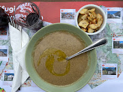

Left: Rifugio Cesare Ponti - Lentil and chickpea soup
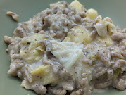
Center: Rifugio Cesare Ponti - pizzoccheri, a dish typical of the Val Valtellina


Left: Rifugio Cesare Ponti - Lentil and chickpea soup
Center: Rifugio Cesare Ponti - pizzoccheri, a dish typical of the Val Valtellina
Right: Rifugio Cesare Ponti - A cheese plate, with bread and honey


Left: Rifugio Cesare Ponti - lunch menu
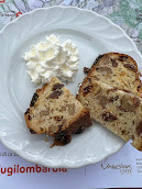
Center: Rifugio Cesare Ponti - la bisciola - panettone valtellinese


Left: Rifugio Cesare Ponti - lunch menu
Center: Rifugio Cesare Ponti - la bisciola - panettone valtellinese
Right: Playing the card game Machiavelli - waiting for bad weather to pass
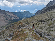
Walking down the moraine formed by the Glacier Predarossa.




No comments:
Post a Comment
All comments are moderated. If your comment doesn't appear right away, it was likely accepted. Check back in a day if you asked a question.