Overview | Arriving | Hike | Cheese | Flora
Overview
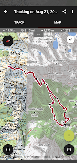
Length: 17.5 km (10.9 miles)
Duration: 5 hours 3 minutes moving time. Full time with lunch and drink at Valtorta was close to 8 hours.
Location: Italy, Lombardy, Val Stabbina, Valtorta
Arriving
We arrived by car from Bergamo. The tricky part is not missing the left turn at Olmo al Brembo to enter the Val Stabina.
We saw there was a bus parked in Valtorta near the visitor's center (at the entrance to the town), so it looks like it's possible to arrive by bus. Check the Bergamo Trasporti for Line B50a. It will likely take a few transfers to get there. Or, rent a car.
Hike
We done a few related hikes in the area, including:
- A Hike to Rifugio Benigni – nearby to the east of Rifugio Grassi, starting in Cusio.
- A Hike to Rifugio Gherardi in Val Taleggio – to the southeast, starting in Capo Foppa (Pizzino)
For today's hike, we parked in Valtorta, under the visitor center, a large free lot. To start the hike, you have two choices. Most hikers, walk the road up to the frazione Costa and pick up the trail there. This is what we did going and this is called trail 104. Coming back from the rifugio, we picked up trail 104A which drops you just outside of Valtorta and then followed a local trail back to the town center. We got lost on trail 104A a few times and decided it would have been hard following this trail up to the rifugio. The signage on 104A was not good.
In these hills, cell reception is nonexistent and Maps.Me is a savoir. When we got off trail, Maps.Me was very useful to know what direction to go in to pick up the trail. Maps.Me uses OpenStreetMap and contains both Club Alpino Italiano (CAI) trails as well as local trails. For example, you can see for Valtorta that you can walk out of town center, avoid going to Costa, and meet up with trail 104. Stay west (hydrographical right) of the Torrente Valle Grobbia. The CAI maps for Bergamo don't have these local trails.

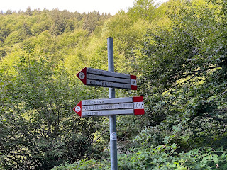


On this hike you cross a number of streams, including:
- Torrente Valle Grobbio
- Torrente Valle del Borae
- Torrente Caravino
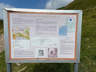
We mention these streams because you cross a number of them and they look similar. Second, the presence of water was important for the mining that took place here in the past. In fact, a hill behind Rifugio Grassi has a sign explaining the mining that once occurred. Since ancient times, cuts and pits were dug in the area looking for easy to get to surface deposits with serious exploration starting in 1900. The main mineral was galena (a natural mineral form of lead) and then barite in the last years of activity before concluding in 1924.
On the subject of mining: on the 104A trail, about 3 km before reaching Valtorta, we started seeing signs marked as "Antica Via del Ferro – Tracciato di particolare interesse storico". This means roughly Ancient Iron Road – Route of Historical Interest. These signs refer to the fact that for centuries the Alta Val Brembana was dotted with furnaces and forges to process the minerals found in the hills. The Via del Ferro connected villages involved in mining before there were the main roads we use today in valley floors.


Also, on this hike you pass through some beautiful beech (Fagus sylvatica) forest. These are called faggeto or faggeta. See the photos in the Flora section. These forests are very open, with lots of distance between trees and next to nothing growing in the understory. We don't know for sure, but guess these are maintained forests with the lumber destined for heating and furniture making.
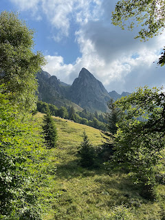
Your midpoint lunch spot on this hike is Rifugio Grassi at 1987 m (6,519 ft), often referred to as La Grassi. The rifugio was one of the best we've eaten at. (Best always goes to Rifugio Gemelli, which borders on gourmet.) We sampled pizzoccheri, a hearty vegetable-based bean soup, and special single dishes (piatto unico) with polenta, local cheeses, and braised meat (brasato).
Cheese
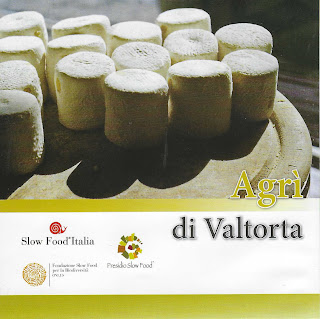
We stopped for a drink in Valtorta at the end of the hike and bought some cheese at the local cooperative, Latteria Sociale Valtora. Not until we go home did we realize how special the latteria is. They are the only producers of the cheese called Agrì di Valtorta, made from whole raw milk from farms in the valley. Agrì have a distinctive cylindrical shape. This cheese is part of the Presìdi Slow Food.
At the cooperative, we also bought fresh yogurt, Stracchino all'Antica, and Formai de Mut. Buying these local items at the end of along hike is so satisfying. We hiked the pastures where the cows graze and now we can taste that grass literally.
Stracchino, orginally a cheese made in Lombardy, is now found in other regions of Italy. The stracchino we bought at the co-op was certainly made just a few kilometers from where we bought it, if that. "Strach" in lombardo dialect means tired and is said to refer to the state of the cows after returning from the high alpine pastures of summer to their winter homes in lower altitudes. The transhumance tires out the cows and they produce less milk with a particular flavor. Stracchino is the precursor of other cheeses like Strachìtunt and Taleggio.
Formai de Mut is a DOP cheese made only in the the Alta Val Brembana. It's name means "Formaggio di monte" being produced by animals pastured at altitudes between 1400 m and 2300 m. All that alpine grassy goodness lends itself to quality milk which is reflected in this cheese.
Flora
As usually happens, we think we didn't see many plants and then we look through the pictures and realize we saw a good number. In the list below, there are many plants in common with the hikes to Rifugio Gherardi and Benigni – in the nearby valleys.
[Family] Scientific name - Common name English (Common name Italian).
[Asteraceae] unknown - unknown (unknown). A yellow flower that was too pretty to not include.
[Campanulaceae] Campanula sp. – Bellflower (Campanula). This is likely Campanula barbata – Bearded Bellflower.
[Caryophyllaceae] Dianthus superbus – Fringed Pink (Garafano superbo)
[Celastraceae] Parnassia palustris - Marsh Grass of Parnassus (Parnassia delle paludi)
[Ericaceae] Calluna vulgaris – Heather (Calluna comune, brugo). Calluna is referred to as Summer (or Autumn) heather to distinguish it from winter or spring flowering species of Erica that looks similar.
[Fabaceae] Trifolium alpinum – Mountain Clover (Trifoglio montano)
[Gentianaceae] Gentianella sp. – Gentian (Genzianella). Likely, G. campestris. Very common above 1500 m along with Euphrasia.
![[Gentianaceae] Gentianella sp. – Gentian (Genzianella) [Gentianaceae] Gentianella sp. – Gentian (Genzianella)](https://blogger.googleusercontent.com/img/b/R29vZ2xl/AVvXsEhJBTsx2HURlRl_FzstnnnprARWOJ3NQmKW1wvqS21_HFh00x6XcSRZc4baFuAfxJ0uPU_DwLv51rncHVGH6MIfxUZBQqtZYeSyT5lRUiZvlS2f6zDkij3eefvdXlY6VlHu5a45TdzBmDA/s320/Gentianaceae%255D+Gentianella+sp.jpg)
[Gentianaceae] Gentiana asclepiadea – Willow Gentian (Genzian di Esculapio). We don’t encounter this plant that often. It's striking.
![[Gentianaceae] Gentiana asclepiadea – Willow Gentian (Genzian di Esculapio) [Gentianaceae] Gentiana asclepiadea – Willow Gentian (Genzian di Esculapio)](https://blogger.googleusercontent.com/img/b/R29vZ2xl/AVvXsEjhiPi-GdmYAIREQF6CoYpTNVRhBJAlLv7MlKPbPgTb-NObnCkf_1nry9vO7VsmgtnvUu6gGkSf-hR2Xv9v9e1PzDyoARFLm2b2CVgT4moW6bauiW0vdt6Yke8Hpzd9n240VtY3OshVxws/s320/%255BGentianaceae%255D+Gentiana+asclepiadea+-+note+dotted+petals.jpg)
![[Gentianaceae] Gentiana asclepiadea – Willow Gentian (Genzian di Esculapio) [Gentianaceae] Gentiana asclepiadea – Willow Gentian (Genzian di Esculapio)](https://blogger.googleusercontent.com/img/b/R29vZ2xl/AVvXsEii4b-ZhSjdPsl_oC0yXKvyeUyvH0z4-pLBHYuravrKQPMgMkWdXi7DThTb0s3JWvenQNNAxsuByrqv4H4ElxTwzFC1J27tw76LLQ5axqqp9-m13yfx8KMj6pVkm0Nq1EJCTlT_lACKnoA/s320/%255BGentianaceae%255D+Gentiana+asclepiadea.JPG)
[Orobanchaceae] Euphrasia sp. – Alpine Eyebright (Eufrasia delle alpi). This genus has a number of species that look similar and we haven't taken the time to analyze them closely so can only go to genus with certainty.
![[Orobanchaceae] Euphrasia sp. – Alpine Eyebright (Eufrasia delle alpi) [Orobanchaceae] Euphrasia sp. – Alpine Eyebright (Eufrasia delle alpi)](https://blogger.googleusercontent.com/img/b/R29vZ2xl/AVvXsEi0M2kCZKo6CQO8YdbMDt6LL083D0NYqQA5-Je1oqm8IFIDskDNsY2e7F2tMez7lsMOwPhrifTPwGmFVnhpMmYvI4wLkmsfpD0zo2lc-vF12FCvZIg1WUVT_euOgLg2BrHdRPF13zv7zbs/s320/%255BOrobanchaceae%255D+Eurphraisa+sp.jpg)
[Orobanchaceae] Rhinanthus sp. – Rattle (Cresta di gallo). Again, this genus has a number of very similar looking species and we could only go to genus identification with certainty.
![[Ranunculaceae] Aconitum napellus – Monk's Hood (Aconito napello) [Ranunculaceae] Aconitum napellus – Monk's Hood (Aconito napello)](https://blogger.googleusercontent.com/img/b/R29vZ2xl/AVvXsEieFzrrqX-dyXiZXHoIZ3QVx5gAjLIJA1JsnDcwLnZW3R0oIzKciKP2UCH5QOAnGReFEnWR4nOrA-3DyAchBavWO11EHcJ2GLEDbIUGZ32AMZczGtmh9FAVx_ShILLweekw0r_sSfFzYUI/s320/%255BRanunculaceae%255D+Aconitum+napellus+1.jpg)
![[Ranunculaceae] Aconitum napellus – Monk's Hood (Aconito napello) [Ranunculaceae] Aconitum napellus – Monk's Hood (Aconito napello)](https://blogger.googleusercontent.com/img/b/R29vZ2xl/AVvXsEhGaQVN8YB8Hr3218c5pGN2pxX1FKmr8vDHg59oH-ogqJSDVohphdoh5_JkbDjwoFksH8cvoDEvzAc6B2-11nLmXgNaVoiO0CXS4SGO0HBaoEHoZYpttBnvZvPQk-FW4F8ofrMX9aretfI/s320/%255BRanunculaceae%255D+Aconitum+napellus+2.jpg)
[Ranunculaceae] Pulsatilla alpina – Alpine Pasqueflower (Pulsatilla alpina)









![[Asteraceae] unknown yellow flower. [Asteraceae] unknown yellow flower.](https://blogger.googleusercontent.com/img/b/R29vZ2xl/AVvXsEgueV-B1Pq2jDkRY1w_4zR2UH2bcvSCpnBB9a_8FLQYQoSgZOcbU5fhRnB09FKWyqNfJXyZVuMxyBuwIpz5WR0sozox_O8Vx-1EdISPRj9BL1UFomf8VTYSz7mBZbWRSUv0H4_q5cKaGAE/s320/%255BAsteraceae%255D+flower.jpg)
![[Asteraceae] Carlina acaulis – Stemless Carline Thistle (Carlina bianca) [Asteraceae] Carlina acaulis – Stemless Carline Thistle (Carlina bianca)](https://blogger.googleusercontent.com/img/b/R29vZ2xl/AVvXsEhKRLEcwfiDI66hXqui3sLUl4B6_mgizlufwaRLRyqmr-Jy2QaPLhyphenhyphen4Nb9cKrgyCpB8n4ouBYOzJ9cWSapKB0TDM0IRB9J_NvfF411aP-Vvkg1InDmxG4mYrbQU5Z6o66FrAa_gM0k57gg/s320/%255BAsteraceae%255D+Carlina+acaulis.jpg)
![[Asteraceae] Schlagintweitia intybacea – Whitish Hawkweed (Sparviere cicoriaceo) [Asteraceae] Schlagintweitia intybacea – Whitish Hawkweed (Sparviere cicoriaceo)](https://blogger.googleusercontent.com/img/b/R29vZ2xl/AVvXsEjTjwvl7cNPn5aM3clS0QRLImsQ_Nv-crALQDxBNaH6p3hMa53U-ppV97k7T9OpvAu9azNDfGy4InOqN5mnFAri8Mo9NEArwvIDxvYfaCPZknv2oGIy1Vffl9V6PVBBn8pMuTmouIw44s0/s320/%255BAsteraceae%255D+Schlagintweitia+intybacea.JPG)
![[Campanulaceae] Campanula sp. – Bellflower (Campanula). This is likely Campanula barbata – Bearded Bellflower. [Campanulaceae] Campanula sp. – Bellflower (Campanula). This is likely Campanula barbata – Bearded Bellflower.](https://blogger.googleusercontent.com/img/b/R29vZ2xl/AVvXsEihzfawdYLEjb5mePONOFHS7RZSO_hTtI8VL2-fL1vwKNxfu9KZuW5T2jo2j_5tKKvcNZe5f4k8Y6HOCzpiBV_0cSSJSFeZucQqdKrktpPviQIzh_RTW46sSMpcDuKZcasU5v0pEo3P69k/s320/%255BCampanulaceae%255D+Campanula+sp.jpg)
![[Caryophyllaceae] Dianthus superbus – Fringed Pink (Garafano superbo) [Caryophyllaceae] Dianthus superbus – Fringed Pink (Garafano superbo)](https://blogger.googleusercontent.com/img/b/R29vZ2xl/AVvXsEivO7PkBl996_MYfR3LRScFVgIce4RgNJoWgI14Up56ZGOBb5B6e61h-8gXUZ67DV8SfNbSmEXR6C-P03Fashf1AgfGJ5wd5pTGELGyaom6PGeASpPdx3Sq95oWXX3tjg0GTvkfAre5nqc/s320/%255BCaryophyllaceae%255D+Dianthus+superbus.jpg)
![[Celastraceae] Parnassia palustris - Marsh Grass of Parnassus (Parnassia delle paludi) [Celastraceae] Parnassia palustris - Marsh Grass of Parnassus (Parnassia delle paludi)](https://blogger.googleusercontent.com/img/b/R29vZ2xl/AVvXsEhTFLTHjvvjZ8k56kX22YOBxqWv_Gr0kKmCzTF9btIYo0fv9yju7PUZCicwOPZLZYeq-vHDrTnO2HMdF1mbcLvUIRCN8cFx5s7GrrF41DRWvTiZly6yP2pnhUO15-AxDkAJVaHKEVw7zCQ/s320/%255BCelastraceae%255D+Parnassia+palustris.jpg)
![[Ericaceae] Calluna vulgaris – Heather (Calluna comune, brugo) [Ericaceae] Calluna vulgaris – Heather (Calluna comune, brugo)](https://blogger.googleusercontent.com/img/b/R29vZ2xl/AVvXsEhbyc2db80RQtfdbM1FN9foor_Hu-8tgjDj-wBb2F5Kaar2b4R8DWXpL_RszcYD6cpUiKvgtfg4kWFRJEyWSKHyoEL7_Q-xKFic7-BD3Ow5FSdMWpyD_-KRQBUDGQrVf1_NsuF_ksFtBUo/s320/%255BEricaceae%255D+Calluna+vulgaris.jpg)
![[Fabaceae] Trifolium alpinum – Mountain Clover (Trifoglio montano) [Fabaceae] Trifolium alpinum – Mountain Clover (Trifoglio montano)](https://blogger.googleusercontent.com/img/b/R29vZ2xl/AVvXsEgcYf1y6zYWPpYFWAHt07DqhyGuxCojaQwUh8C9KZW2Oqs7U3DOHWp_oyflGS8zl0_J00qBxPC-USq2dh2ceaukwM-Kb4pPf3knX7z6TtOI9Sn_LC_Zg8j8nkZ3ff-hT13sNvVNT3X9dw4/s320/%255BFabaceae%255D+Trifolium+alpinum.jpg)
![[Fagaceae] Fagus sylvatica – European Beech (Faggio) [Fagaceae] Fagus sylvatica – European Beech (Faggio)](https://blogger.googleusercontent.com/img/b/R29vZ2xl/AVvXsEi5ucrZ-VIM7cVDTFCYIwOkZ_QOM_uZs3IFEbD4k8uwEHyHq9RnlsRBe_hi8dJN7tySZ8mGTxFA3UL_idO3MVhM2niYl44a_W6VcdQxWJI5e_M_vCVjbfkPHVlTtxl8LyryF-aUiB25ZFc/s320/Example+of+beech+forest+1.JPG)
![[Fagaceae] Fagus sylvatica – European Beech (Faggio) [Fagaceae] Fagus sylvatica – European Beech (Faggio)](https://blogger.googleusercontent.com/img/b/R29vZ2xl/AVvXsEiWV2MggMCnOiwrDDPRnE7jnO54wCy7uzEnYbwSxfOqyr-a7kp1O7w29DcNDigzWMqWpEWCnN15dax_PNk7zYopS0JRXOTAPuXuoH7aHlaK0cwPurgPQmaK1bgIHzCRSTIYc_Bu37icmO4/s320/Example+of+beech+forest+2.JPG)
![[Fagaceae] Fagus sylvatica – European Beech (Faggio) [Fagaceae] Fagus sylvatica – European Beech (Faggio)](https://blogger.googleusercontent.com/img/b/R29vZ2xl/AVvXsEjxRYuO2QJZV-Gj5c-0OcrfV3Uxoy5ZkYI5pTNLax7nD-iNWC3bHPl3Zt_-LaOmhdXO0GGYXDehlDNDfj3e1DgRlAYnIiECFrrsvF-bmW8r7kHQiCQ4O7GL_CV_Xp4mPKF6SA7Bt8fzl5Y/s320/A+beech+tree+above+Valtorta%252C+Italy.JPG)
![[Lamiaceae] Prunella vulgaris – Selfheal (Prunella comune) [Lamiaceae] Prunella vulgaris – Selfheal (Prunella comune)](https://blogger.googleusercontent.com/img/b/R29vZ2xl/AVvXsEgkeFsJpnEuvuVU9GtYIc4SKMgqYl7Jr52NEr_Da89_gkqCX43lfubXSjvEEKGCGyYOyAakXqXClUnAU5rhNZ4J-nv1Kgzv5h8P4-091c0AOyBJIxDvLau795EcyoDwT0so8E5Hx-gpqMM/s320/%255BLamiaceae%255D+Prunella+vulgaris.jpg)
![[Orobanchaceae] Rhinanthus sp. – Rattle (Cresta di gallo) [Orobanchaceae] Rhinanthus sp. – Rattle (Cresta di gallo)](https://blogger.googleusercontent.com/img/b/R29vZ2xl/AVvXsEjLtKtSHAKBHEQJ6XSyr-0juY8V3EY3UPT3J8K7x9X826cgaEGFKlCwllk3eR_iEBCr97mioBv6DqJBWeU-rWwOzDq5cjJ_DgFxysKD0VWinjae8GEhy_OBG5vbupe5Rpx4kuEAWAKBg-w/s320/%255BOrobanchaceae%255D+Rhinanthus+sp.jpg)
![[Polygonaceae] Bistorta officinalis – Meadow Bistort [Polygonaceae] Bistorta officinalis – Meadow Bistort](https://blogger.googleusercontent.com/img/b/R29vZ2xl/AVvXsEhs319pzSHVLgvU7qjkwrRE4mFAA6qlq3ra9K7Y3oQAzp_Y0TDhLW3hCFjPkJ_y3ZmdhaSeuyUan1rg48cCRHDUNjaO8aY3HgYpPzqq65p7nmg7tc_syh3GDYJyfbKfGtEpxErg2Bvt9Pk/s320/%255BPolygonaceae%255D+Bistorta+officinalis.jpg)
![[Ranunculaceae] Pulsatilla alpina – Alpine Pasqueflower (Pulsatilla alpina) [Ranunculaceae] Pulsatilla alpina – Alpine Pasqueflower (Pulsatilla alpina)](https://blogger.googleusercontent.com/img/b/R29vZ2xl/AVvXsEiCagOliGXi0fURywRb2nj1DnLmI2FJrHqrcj8OAeTqb9by7j9LOu0qWUszvevK-jNetTvq9cl-ChdtMLzIhKcalr91FZwZ7a2NIOIW1oXtHz-l2BXR8iP4ufK35vV6xDt3nt0hPNgHSo4/s320/%255BRanunculaceae%255D+Pulsatilla+alpina+-+bald.jpg)
![[Ranunculaceae] Pulsatilla alpina – Alpine Pasqueflower (Pulsatilla alpina) [Ranunculaceae] Pulsatilla alpina – Alpine Pasqueflower (Pulsatilla alpina)](https://blogger.googleusercontent.com/img/b/R29vZ2xl/AVvXsEizBSSZ-SgBbOVzyMAjhhWXuUmuWdyO-HdbNxxwSSv0CBbykJ7mBwWzmUkMUAqYvPRGFsbj5W0afFz2fZ3JgDwoouR9gByofuIKLIj_tc0kpk8nDV3CCVEVfY0mICd6_pGL3fgTZ3ZjBAU/s320/%255BRanunculaceae%255D+Pulsatilla+alpina+-+group.JPG)
No comments:
Post a Comment
All comments are moderated. If your comment doesn't appear right away, it was likely accepted. Check back in a day if you asked a question.