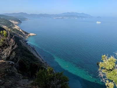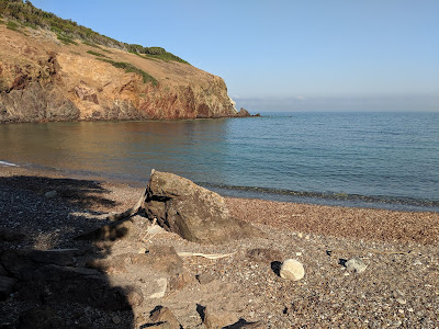


Left: Run route above Nisportino Elba reported on ViewRanger. Center: View above La Rivercina beach toward Portoferraio. Right: View over Spiaggia dei Mangani with colored Mediterranean macchia.
Overview
Length: 7.35 km (4.6 mi)
Duration: 2.25 hours (We ran for about ½ the distance. Time also includes a 20 minute swim at Spiaggia dei Mangani.)
Elevation: 526 m (1726 ft) gain
Location: Nisportino, Rio nell’Elba, LI, Tuscany, Italy
Details
This post describes the second of two run/hikes we did while staying on Elba. The first hike was A Run/Hike – Monte Strega, Rio nell’Elba. Like the first hike, we did this run/hike as early in the morning as possible to avoid the heat. Nisporto and Nisportino are on the west side of a mountain range so they are shaded in the early morning, which helps with early morning physical activities.
Does Nisportino mean little Nisporto? At least that’s the way diminutives should work in Italian. Nisportino is indeed smaller and Nisporto larger. Nisportino doesn't have boats anchored in its waters and Nisporto does. Nisportino is slightly more upscale. We were staying in Nisporto but found ourselves liking Nisportino a bit more as a beach and place to go, especially with the nice restaurant Ristorante Pizzeria Bar "La Battigia" (breakfast, lunch and dinner). It's about a 10 minute drive between the two even if swimming between the beached is under 2 km. We tried it.
Side note: We don’t know much about money laundering in Italy, but we have noted that among our Italian friends there is a consistent vein of thought and it is this: if a restaurant in the north* has a lot of staff that seem to come from the south of Italy (and our friends say they can tell), has low prices, then there is a good chance the restaurant is a front money laundering business. During our stay on Elba (which is in Tuscany), a restaurant that “seemed” to be Tuscan owned was looked at more favorably than one that satisfied some of the criteria given above.
* Let's not start on what even constitutes "north".
We went looking. According to ANSSAIF, from the most recent “… official estimate (2014), the total size of Italy’s black market is estimated to be 12.4 percent of GDP (approximately €210 billion or $229 billion). The actual share may be larger.” That's a sizable chunk of the GDP. In an article from La Stampa, it is estimated that 5,000 restaurants in the province of Napoli alone are in the hands of organized crime. La Stampa article continues with examples of shuttered restaurants in Torino, Rome, and Milan, so the problem is across Italy.
Why a restaurant you might wonder? Because it’s a cash-intensive business where illegal cash can be easily combined with legal cash. Also, staff jobs in an “owned” restaurant can be doled out to family or those loyal to the organization. Finally, some restaurants start as legal, but due to loans that can’t be paid back to organized crime organizations they become “owned”. Downturns in the economy and reduced bank lending lead people to other sources of loans. Hmm, maybe our Italian friends are right?
Back to the run/hike. Here’s what we did:
- This route goes counterclockwise, starting and ending at the beach in Nisportino.
- From Nisportino beach head east by southeast on Via Nisportino, always climbing to find a trail (approximately at 42.830644, 10.392829).
- Leaving the asphalt, take the wide trail (it may be called 101) to the crest of the mountain and the “piazza” on the crest of the mountain separating Nisporto/Nisportino from Rio nell’Elba. The piazza is a pull off the main road just north of Monte Strega. It is really a dirt space where many trails intersect and bicyclists, motorcyclists, walkers, and runners naturally congregate.
- From this high point, take trail the GTE, heading north and start descending. The GTE or “Grande Traversata Elba” is a 60 km mountain bike path that runs from Chiessi in the west of the island to Cavo in the northeast of the island.
- Follow the trail passing around something called Case Nardelli and then hit an open space for transmission lines and go slightly uphill to SP 33.
- From there look for the signs for either Spiagga dei Mangani or trail 265 and head west toward the beach. You are passing through leccio or Quercus ilex.
- At the beach, take a swim and enjoy the isolation of Spiaggia dei Mangani.
- With shoes back on head south toward Nisportino, just another 15 -20 minutes away to arrive at where you started. The track between Spiaggia dei Mangani and Nisportino is quite high up and offers some great shots o the coast looking toward Portoferraio.
Why is it called the Pietre Rosse? From the red rocks cliffs of Punta dei Mangani. Standing on the Spiaggia dei Mangani, you can see the contrasting colors. On the left the red promontory of Punta dei Mangani and on the right, the white limestone edges of Monte Grosse.
Side note: Yet another endorsement for MAPS.ME and their offline capabilities. Really, they don’t pay us to endorse them! But this app is a lifesaver in terms of navigating with or without network. Without network, Google Maps is a nightmare. With network, Google Maps just doesn’t have the detail like MAPS.ME. Sure, Google Maps gives you the weather and traffic and other bits of info. But that’s not what you need when you are in the middle of nowhere with no cell coverage and you need to know which way to go. There are other more “serious” navigation apps for sure, but MAPS.ME works for most common offline situations.


Left: Trail marker 265 - Percorso Pietre Rosse. Center: Making our way up from Spiaggia dei Mangani, Elba. Right: A sign describing the Percorso Pietre Rosse.


Left: ViewRanger distance, speed, duration, and altitude profiles. Right: Spiaggia dei Mangani and the trail to Nisportino.


Left: The trail takes you through a forest of leccio - Quercus ilex. Center: Sign for the GTE. Right: The trail on the ridge of the hill above Nisporto/Nisportino Elba.


Left: View toward Monte Capanne in the distance - the highest point on Elba at 1019 m (3343 ft). Center: View from GTE looking west down toward NIsportino (which is hidden). Right: Spiaggia dei Mangani, Elba, from the trail.


Left: Panorama of Spiagga dei Mangani, Elba. Right: A peaceful beach: Spiaggia dei Mangain and the red Punta dei Mangani.


Left: View of Spiaggi and Punta dei Mangani. Center and left: Looking back from Pietre Rosse trail toward the beach.


Left: On the trail near Punta delle Casette, just before coming to Nisportino. Right: Nisportino beach from Punta delle Casette.
No comments:
Post a Comment
All comments are moderated. If your comment doesn't appear right away, it was likely accepted. Check back in a day if you asked a question.