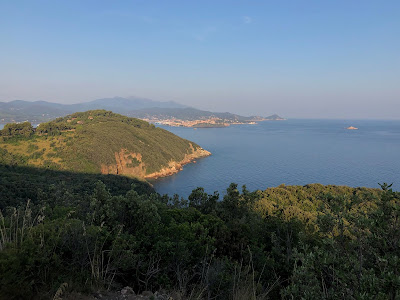


Left: Run route above Nisporto Elba reported on ViewRanger. Center: On the mountain crest looking down on Nisporto. Right: Trail 253 above Nisporto Elba.
Overview
Duration: 1.5 hours (We ran for about ½ of the distance.)
Elevation: 599 m (1965 ft) gain
Location: Nisporto, Rio nell’Elba, LI, Tuscany, Italy
Details
This post describes a run/hike we did while staying on Elba in Nisporto for a few days. The lure of the nearby Monte Strega was strong and called to us to explore. And we did. We got up one morning as early as we could muster to try and beat the heat and we climbed out of Nisporto to the top of Monte Strga. Obviously, the route we did can be done walking and would be more enjoyable, and you’d have time for more photos!
For another hike we did on Elba see: A Run/Hike on Elba - Nisportino and the Pietre Rosse Trail, Rio nell’Elba.
Elba is the third largest island in Italy, after Sicily and Sardinia. There is a lot to explore on this island and even in our second time here, we barely scratched the surface. Elba is part of the province of Livorno (what we call Leghorn in English), which is part of the region of Tuscany. The island probably rings a bell for most as the place Napoleon was exiled to in 1814 – 1815. He only stayed 10 months but seemed to have carried out a lot of reforms and improvements to the quality of life for its inhabitants.
Nisporto is a small district that is part of the town Rio nell’Elba, though the two are separated by a mountain range and it takes 15 – 20 minutes by car to travel between them. If the shape of Elba is a fish swimming west, then Nisporto and Rio nell’Elba are located the upper back fin of said fish and are separated by mountain range reaching 427 m (1400 ft).
Here’s a rundown of what to do to follow the run/walk described here.
- This route goes counterclockwise, starting and ending in Nisporto.
- Take the asphalt road Via Nisporto south toward Bagnaia. This is a steady uphill climb that eventually flattens out and goes down slightly.
- At a certain you reach a sign that signals trail 253 “Innesto GTE”, which means connector for the GTE. The GTE stands for “Grande Traversata Elba”, a 60 km mountain bike path that runs from Chiessi in the west of the island to Cavo in the northeast of the island.
- Take trail 253 – always climbing – until you reach a saddle with a few choices. Just off to the east and down is Rio nell’Elba. You instead, will take the trail going north that continues up toward Monte Strega.
- Upon reaching Monte Strega, stop and admire the view on your high point on this trip at 427 m (1400 ft).
- Descend quickly from Monte Strega to reach another saddle and the main asphalt road running between Nisporto and Rio nell’Elba. This location has a large pull-out area and is a frequent gathering place for bicyclists, motorcyclists, and walkers. A number of trails intersect at this point.
- Take the road back down into Nisporto.


Left: Sign for trail 253. Center: Trail signs above Nisporto indicating GTE and Monte Strega. Right: ViewRanger distance, speed, duration, and altitude profiles.


Left: On the road to Bagnaia. Center: View from trail 253 toward Castello del Volterraio. Right: Last push up to Monte Strega.


Left: Looking south along the spine of the mountains between Rio nell'Elba and Nisporto. Center: View from road to Bagnaia toward Portoferraio. Right: The winding road leading to Nisporto, which is part of the route.


Left: View west over Nisporto with Portoferraio in distance. Right: Jogging into Nisporto and heading toward the beach.
No comments:
Post a Comment
All comments are moderated. If your comment doesn't appear right away, it was likely accepted. Check back in a day if you asked a question.