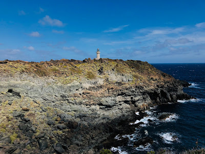


Upper left: Ecotrails run - heading toward Lago di Specchio di Venere.
Upper right: Ecotrails run - last part heading to the finish at Punta Spadillo.
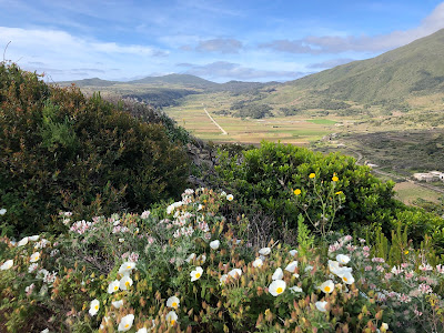
Lower left: Above Khamma on the Serra Ghirlanda trail overlooking the beautiful Piano Ghirlanda.
Lower right: View from Mueggen looking over zibibbo grape vines toward Montagna Grande.
Overview
We were on the Island of Pantelleria (Sicily) for six days during the end of April and we did one medium-effort hike and two runs. This post is a summary of those three outings plus information for other hikes and walks on the island that we collected during our time there. The runs we did could easily be done as walks or hikes. For an overview of our time on Pantelleria, see the post Six Days on the Island of Pantelleria, Sicily.
Montagna Grande Hike
Montagna Grande rises to 836 m (2743 ft) and is a point of reference from all points on the island of Pantelleria. On our first full day on Pantelleria, this was our goal somewhat strangely given that we came here to enjoy the sea.
We started in our car from the Khamma area (Piazza Perugia) and worked our way up to the mountain following at first Via Sopra Portella, then Salita Mueggen, and then the Località Montagna Grande road. We didn’t find a definitive place to stop and park, so we pulled over where there was space in the road and we felt that our poor Fiat rental couldn’t go any further. A jeep would have been better. By the way, no matter what you do on Pantelleria, sooner or later you’ll be driving on a dirt road be it to reach a trailhead or get to a beach.
After parking, we kept following the road until we found signs pointing “Grotta dei briganti” or “Area attrezzata”. Much of the hike is either on a dirt road or what I would call a fire break, clearly visible on Google.
After reaching the communication tower on top of Montagna Grande, we turned around and made our way back to the car. I wouldn’t say it was a beautiful hike for two reasons. The first reason is that the trail simply isn’t that interesting. Second is that the day we were up on the mountain the atmosphere was extremely hazy, so views were not great.


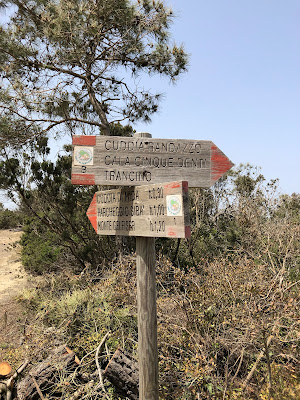
Left: Approximate trail followed to the top of Montagna Grande on Pantelleria. Center and right: Signage on the trail to the top of Montagna Grande.


View of Montagna Grande hike including cleared area (fire break) and view of M. Gibele crater. Note hazy air; we just happened to go up on a bad day.
Hike/Run in the Khamma Area
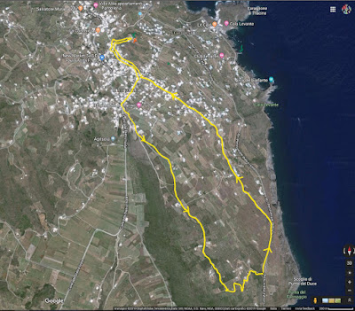
We stayed in a dammuso in the Khamma area and on the last day of our stay, we went for a jog with our dammuso as starting and stopping point. You could also start and stop in Piazza Perugia in Khamma. Our jog could easily be taken as an easy walk or hike. Approximate stats:1 hour, 6.5 km, and 200 m elevation gain.
We headed up to Tracino center (Piazza Perugia) and then south along the Serra di Ghirlanda (the old caldera rim), took a left and headed east down to the perimeter road and then back to house. See the attached image for the trail.
For information about the term dammuso and cuddia (shown in the Montagna Grande trail signs), see the post Pantelleria – Street Sign Language Lesson XXVIII.


Left: Dirt road / trail near Khamma on the Serra Ghirlanda heading south. Center and right: Heading north on a small road (Via Kania) toward Khamma/Tracino.


Left: A small roadside altar on Via Kania on the way to Khamma/Tracino. Center left: Map of Pantelleria showing different itineraries - road, dirt road, and trail. Center right: Map of Pantelleria showing different itineraries with some volcanic features. Right: Jogging route we took from Khamma - also good for walking.
EcoTrails Pantelleria 2019
By chance we were on the island during the Ecotrail Sicilia Pantelleria Race, 28th of April 2019. We met one of the organizers on Montagna Grande a few days earlier. He was setting out the course for the 50k, and he encouraged us to sign up. We did and ran the 10k for fun. We were the "international" participants.
The trail we ran for the 10k would be just as interesting as a walk. The trail starts at Punta Spadillo (where the lighthouse is), takes in some of the coast, turns inland to Lago di Specchio di Venere, goes through the Bugeber area, and then returns to the lighthouse.
The other categories of the race, 21k and 50k, could be interesting walks to break over several days or just do part of. All paths are shown in the images accompanying this post.


Trail profiles for different races of the Ecotrail Pantelleria 2019 race: Walktrail, Gelfiser, and 50k.


Trail maps for Ecotrail Pantelleria 2019 race: Walktrail, Gelfiser, and 50k.


Left and center left: Trail along Punta Spadillo, Pantelleria. Center right and right: Lago Specchio di Venere, Pantelleria.


Left: View toward Lago Specchio di Venere, Pantelleria. Center and Right: Views of Bugeber, Pantelleria.


Left: An enticing trail in Bugeber, Pantelleria. Right: A trail along the coast heading to Punta Spadillo.
No comments:
Post a Comment
All comments are moderated. If your comment doesn't appear right away, it was likely accepted. Check back in a day if you asked a question.