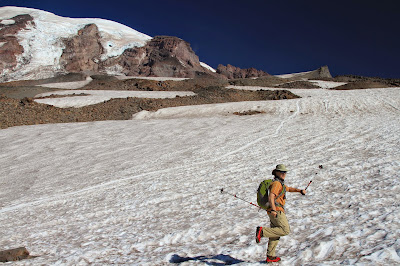
Upper Left: View from Skyline Trail Toward Muir Snowfield; Upper Right: Camp Muir Looking West; Lower Left: Our Route Up and Back; Lower Left: On the Muir Snowfield, A Hiker Alongside a Glissade Path
Hike Notes
Length: 10.7 miles (according to our Garmin HCX)
Duration: 7.25 hours (8:15 am – 3:30 pm), includes 60 min lunch break at the camp
Elevation Gain: 4,680 ft. (total), 10,080 ft. max elevation at Camp Muir, starting @ Paradise 5,400 ft.
Location: Mt. Rainier
For our seventh hike of the summer 2014 (and bringing us to 95.5 total miles), we hoofed it up to Camp Muir (WTA site). Some observations:
- On this September day, it was warm. We hiked almost the whole time in short sleeves, except when we sat down for lunch.
- We didn’t hit snow until something like 8,000 feet and even then, if you wanted, you could stay off the snow for a bit longer. However, we found it was actually easier to just get on the snow and start walking rather than avoid it.
- We used trekking poles and KAHTOOLA MICRO spikes that were more than adequate for this hike on this day. These micro spikes were easy to pull on and off and much better than walking without them.
- We started early and saw almost nobody going up (preferable). On the way down we saw a boatload of people heading up. The analogy of a line of ants going to a sugar bowl (Camp Muir) would not be out of place.
- The snow was much more slushy on our way down, which is okay for going down but perhaps isn’t fun when climbing up.
- There was just one “tricky” spot in the snowfield (near the top) that was icy with small (very narrow) “crevasses”. There were flags to warn you and paths over the crevasses were obvious. Still, don’t take them lightly.
- Yes, we brought trash bags to slide down (glissade) and we did. Bring heavy duty bags. Better yet, bring waterproof pants, slip them on, and just go down like that. Most people on the way up just stared at us with blank faces as we slid past them. We weren’t sure if they were annoyed or wishing they had an earlier start.
- I was expecting Camp Muir to be more extensive, with more places to sit and take in the view. That really isn’t the case, it’s just a dry ridge divides the Muir snowfield from the Cowlitz Glacier. Most of the climbers the day we there were sprawled out on the main level of the ridge, which left the upper level for the day hikers. It’s near the bathroom where you’ll catch a whiff or two. You can’t explore any more further past the ridge without being tied together – at least that’s what a sign said.
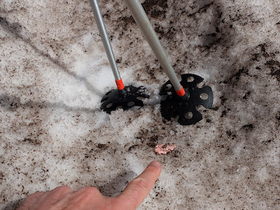
- While the Muir snowfield seemed free of litter, I was surprised at number of pieces of gum we spotted, especially the bright pink and greens. People: swallow the gum or put it a piece of paper in your pocket.
In the Google Earth image of the trail included with this post, it shows that we followed one part of the Skyline Trail up to the turn off to Muir and followed a different part of it back to Paradise.
Meadow Along Skyline Trail
Left: View Looking North, Meadow to Snowfield to Mount Rainier; Right: Sign at Turnoff to Pebble Creek
Left: Small Crevasse in Muir Snowfield; Right: One of Many Gum Sightings – People, Really?
Left: Nisqually-Wilson Glacier – The Muir Snowfield is to the Right of That; Right: View from Camp Muir Looking South, Over Paradise Lodge Where the Hike Started
Left: Starting Walk Up Muir Snowfield; Right: Coming Down Muir Snowfield Using Butt Glissading
Left: Another 1,000 Or So Feet To Go to Get to Camp Muir; Right: View from Skyline Trail Looking North Toward Rainier.jpg)


.JPG)


No comments:
Post a Comment
All comments are moderated. If your comment doesn't appear right away, it was likely accepted. Check back in a day if you asked a question.