Overview
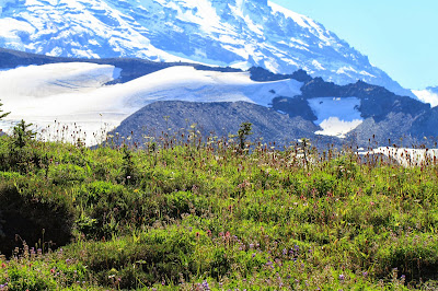
Left: View of Burroughs Mountain and Mount Rainier from Fremont Lookout; Right: Winthrop Glacier from Burroughs Mountain
For our eighth hike of the season we decided to try hiking from the Sunrise Visitor Center, Mount Rainier National Park. At 6,400 feet, Sunrise is the highest point you can reach by vehicle. On this clear, sunny day we struck out around 9:15 am. Ten hours later we were back at car, making for a very tiring day. We managed to cover 20 miles and do the following (in order):
- climb to the Mount Fremont Lookout (7,181 feet). This is one of four remaining historic fire lookouts built in the early 1930s by the Civilian Conservation Corps (CCC). The other three are Tolmie, Shriner, and Gobbler Knob Lookout. The CCC was a work relief program (1933 – 1942) that was part of the New Deal providing “unskilled manual labor jobs related to the conservation and development of natural resources in rural lands owned by federal, state, and local governments.”
- climb Skyscraper Mountain (7,018); At the peak, we encountered a lot of bees and flying ants, and while not bothering us, nonetheless, it was a bit uncomfortable. We talked briefly with a lady who studied entomology and she said that insects (or she might have specifically said bees) go to peaks to mate. True?
- come down from Skyscraper peak and go to Granite Creek following the Mystic Lake Trail.
- return back to Frozen Lake and follow the Burroughs Mountain Trail to Burroughs Mountain 3 (the third hump of the Burroughs Mountain) at 7,820 feet. Burroughs Mountain is classified as an alpine tundra. It differs from an artic tundra in that snow melts and drains way in an and does not remain frozen or puddled on the surface.
Stories in the Landscape
Many of the things we saw today were named after people. Here’s a short list:
- Winthrop Glacier, on the northeastern side of Mount Rainier, is named after writer, lawyer, and traveller, Theodore Winthrop (1828 – 1861).
- Burroughs Mountain on Mount Rainier's northeast slope honors naturalist and essayist John Burroughs (1837 - 1921).
- Emmons Glacier, on the northeaster side of Mount Rainer is named after geologist Samuel Franklin Emmons (1841 – 1911).
- Fremont Lookout. According Mount Rainier, a record of exploration [p. 314, 1916] the origin is uncertain. After many things named Fremont, it could likely be to honor the American military office, explorer, and politician John C. Frémont (1813 – 1890). From the forward of The Expeditions of John Charles Frémont: “John Charles Fremont (1813-90) explored the American West at a time when thousands of migrants were hungry for in- formation, and thus became—with the possible exception of Lewis and Clark — the most acclaimed traveler of the nineteenth century in the lands beyond the Missouri River. He married the daughter of a powerful western senator, Thomas Hart Benton, and added the advantages of family influence to his own store of ingenuity, endurance, and courage.”
- And while we are at it, Mount Rainier’s current name honors the British naval officer Rear Admiral Peter Rainier (1741 – 1808).
- Finally, the standout plant on this hike is surely Polygonum newberryi, Fleeceflower, Newberry’s Knotweed. It is a member of the the Buckwheat family. At this time of the year, it’s a brilliant red with pieces of it blowing around a little like tumbleweeds. We were startled by it several times as it rattled by propelled by a gust of wind. This plant’s specific epithet honors John Newberry (1822 – 1892), surgeon and naturalist.
Left: Fremont Lookout Trail; Center: Skyscraper Mountain; Right: Burroughs Mountain
Mount Rainier Tephra
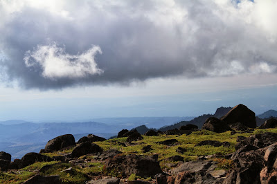
On the walk on Burroughs Mountain we noticed the barren, rocky surface of the tundra. The pumice rocks reminded us of our previous hike through Spray Park and up towards Observation Rock, just west of Burroughs Mountain. After the hike, we started reading up on Mount Rainier’s post-glaciation volcanic past and realized that we were seeing the results of a past eruption of Mount Rainier. The story of the near-volcanic past of Mount Rainier is told in its tephra layers.
- What is a tephra layer? – Tephra is a term that refers to fragments of rock and lava blasted into the air by volcanoes. Over time, tephra builds up into layer. Tephra material is classified by size. Ash is the smallest with particles less than 2 mm in diameter. Lapilli is material between 2 and 64 mm. Volcanic bombs or blocks characterizes material greater than 64 mm. You often also see the words scoria and pumice used to refer to volcanic rock. Scoria is denser (has less pore space) than pumice. Both scoria and pumice are not found very far from an eruption site, while ash can be carried by the wind far away from an eruption.
- How many layers of tephra are there around Mount Rainier? – At least 22 in the last 10,000 years which is the approximate time since the last major glaciation.
- How are the tephra layers named? – Mount Rainier tephra layers are named using alphabet letters chosen after a physical characteristic of the layer. For example, layer Y is a yellow layer of pumice, layer O is an orange layer of material originating from Mount Mazama, and layer C is a coarse brown pumice layer.
- When was the last layer created? - Layer X was created about 190 years ago between 1820 and 1855.
- What’s an exotic tephra layer? – An exotic tephra layer is one that originates from somewhere other than Mount Rainier. Volcanic ash from Mount St. Helens and Mount Mazama (Crater lake) in Oregon can also be found in the tephra layers of Mount Rainier.
- What’s this have to do with Burroughs Mountain? – Burroughs Mountain is a lava flow known as andesite. Burroughs Mountain is similar to several ridges radiating out from the base of Mount Rainier like Mazama Ridge and Rampart Ridge. These ridges resisted erosion from rivers and glaciers. On top of this old lava flow, post-glaciation eruptions from Mount Rainier left their mark in today’s tephra layers. The thickest and most widespread layer is a pumice tephra layer called layer C, which is found throughout the eastern and northeastern parts of the park like Burroughs Mountain. Layer C forms a thick brown veneer on the surface of parts of Burroughs Mountain. Layer C was created approximately 2,200 years ago.
Sources:
1. Tephra Explorer: Living with a Volcano in Your Backyard from the National Park Service
2. Other Pyroclastic Deposits in Mount Rainier National Park, Washington by Donald R. Mullineau, Geological Survey Bulletin 1326 [1975].
3. Surficial Geology of Mount Rainier National Park Washington by Douglas R. Crandell, Geological Survey Bulletin 1288 [1969]
4. The Geologic Story of Mount Rainier by Douglas R. Crandell, Geological Survey Bulletin 1292 [1969, revised 1983]
5. http://en.wikipedia.org/wiki/Scoria
Left: Pumice Landscape on Burroughs Mountain; Center: Hiking from Burroughs 2 to Burroughs 3; Right: View of Little Tahoma and Mountain Rainier from Burroughs Mountain
Tephra Layers Description from Other Pyroclastic Deposits in Mount Rainier National Park, Washington by Donald R. Mullineau, Geological Survey Bulletin 1326 [1975]


Hike Stats
Length: 19.8 miles round-trip.
Elevation Gain: 5,280 feet cumulative, by GPS. Highest point 7,820 feet. Trailhead at 6,400 feet.
Duration: About 10 hours. Started at 9:15 am from trailhead in Sunrise parking lot. Returned to car at 7:30pm. Lunch at the river (Granite Creek) at 1:30pm.
Location: Mt. Rainier -- NE - Sunrise / White River, Mount Rainier National Park
Farthest point reached on Burroughs Ridges (3):
N 46 degrees, 54.211 minutes -> 46.90352
W 121 degrees, 42.815 minutes -> 121.71358
46.90352, -121.71358
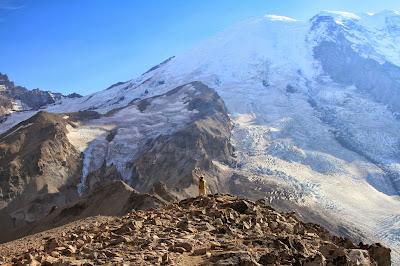
Left: A Hiker Contemplates Steamboat Prow and Mount Rainier Glaciers; Right: Looking North onto Berkley Park
Left: Dasiphora fruticosa near Frozen Lake; Center: Juniperus on Fremont Lookout Trail; Right: Eriogonum pyrofolium – Pyrola-Leaved Eriogonum or Dirty Socks!
Polygonum newberryi, Fleeceflower, Newberry’s Knotweed
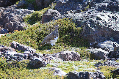
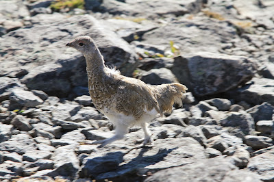
Left: Lagopus leucura – White-tailed Ptarmigan on Fremont Lookout; Right: Young Male with Start of Reddish Eyecomb
Left: View from Burroughs Mountain to Little Tahoma; Right: View of Burroughs Mountain from Skyscraper Mountain
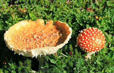
Left: Burroughs Mountain Raven; Right: Sarcodon imbricatus - Scaled Hedgehog – Near Granite Creek
Left: View from Burroughs Mountain, Looking North Toward Skyscraper Mountain and Fremont Lookout; Center: Skyscraper Mountain from Burroughs Mountain – Looks Like a Mayan Temple; Right: Sunrise Lodge Close to Sunset
Left: Topology Map of Sunrise Hike; Center: Topology Map of All Four Hikes This Season Around Rainier; Right: Garmin Stats for this Hike

Panorama from Skyscraper Mountain Looking East Toward Fremont Lookout
Left: View from Fremont Lookout to Echo Rock and Observation Rock; Right: View of Emmons and Winthrop Glaciers Above Steamboat Prow
Left: View Over Winthrop Glacier From Burroughs Mountain; Right: View Over White River from Burroughs Mountain
Left: View from Burroughs Mountain 3 (3rd Hump) to Winthrop Glacier; Right: Sign at the Point Where You Diverge from the Burroughs Mountain Trail to go to Burroughs Mountain 3.


.JPG)






+and+Fremont+Lookout+(Right)+from+Burroughs+Mountain.JPG)


+and+Observation+Rock+(right)+looking+toward+the+West+from+Fremont+Lookout.JPG)
+and+Winthrop+Glacier+(right).JPG)


.JPG)


,+Clintonia+uniflora+(middle,+blue),+Rubus+pedatus+(right,+red).JPG)


