

Top Row. Left:View from above Railroad Pass toward Eldorado Wilderness Area. Right: View from above Cascata Golf Course toward Eldorado Wilderness Area. Bottom Row: Viewranger tracks and information for the River Mountains Henderson hike.
Overview
Length: 12 km (7.5 mi)
Duration: 2 hours (We ran some parts of the trail.)
Elevation: 230 m elevation gain (755 ft)
Location: River Mountains, Clark County, Henderson, Nevada, USA
Type: loop
Details
When we tell friends that we are going to Las Vegas they think of the strip. However, most of our time is spent in nearby Henderson (officially, the City of Henderson) at “grandma’s” house bordering the desert on the west of the River Mountains area.
The River Mountains are between Henderson to the west and Lake Mead to the east. The River Mountains Trail is a 34-mile paved trail that circumnavigates the River Mountains connecting Lake Mead National Recreation Area, Hoover Dam, Henderson, Boulder City and the rest of the Las Vegas Valley. We rode the trail in 2013 and described it in the blog post River Mountains Loop Trail.
The loop trail is measured with mile markers with zero at Railroad Pass and subsequent markers moving clockwise. Railroad Pass (2376 ft) is a pass at the southwest end of the River Mountains connecting Henderson with Boulder City.
On a beautiful Monday morning, we set out around 6:30 am and decided to try a short jog. We enter the trail around mile marker 2 and head south toward Railroad Pass. At R-10A Reservoir we see a sign for Railroad pass via a mountain bike trail and head off on that. Curiosity gets the most of us as we keep wanting to see what’s ahead. Rounding Railroad Pass, we catch our first glimpses of The Black Canyon Wilderness Area and the Eldorado Wilderness Area in the distance.
A few minutes past Railroad pass, we end up at the west edge of the Cascata Golf Course. The golf course describes itself as “a 418-foot waterfall cascades over the steep mountainside that towers above the practice ground. The water meanders through the practice facilities, merging into a river that roars through the very heart of the Tuscan-inspired clubhouse…” The waterfall is artificial much like the little piece of Tuscany in the desert. I don’t care for borrowed architectures in inappropriate contexts, but then again, this is Las Vegas – or close enough to it.
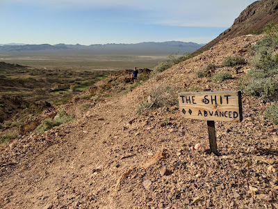
After stopping to ponder the unexpected lushness of the golf course in the middle of the desert, we decided to make our way north through the mountains following a well-used bike trail. There were few trail markings except one called “The Shit Advanced”. We used MAPS.ME (which uses openstreetmap.org data) to see what trails were available to us.
After a short time, we were back at mile marker 2 where we started.


Top Row. Left: Map of River Mountains area. Center: View of Cascata Golf Course from the trail. Right: Cascata Golf Course waterfall - Boulder City.
Bottom Row. Left: A sign for the mountain bike trail called "The Shit". Center: Heading north on the trail. Right Heading west back toward Henderson.
Flora
The River Mountains are part of the Mojave Desert, an arid rain-shadow desert and the driest desert in North America. The desert west of River Mountains can be described as creosote bush scrub, a North American desert vegetation type of sparsely but evenly spaced desert plants dominated by creosote bush (Larrea tridentata) somewhat evenly distributed over flat or relatively flat desert areas that receive between 2 and 8 inches of rain each year.
For help on identification we used Southwest Desert Flora.
[Asteraceae] Baileya multiradiata – Desert Marigold
[Asteraceae] Chaenactis stevioides – Desert Pincushion
[Asteraceae] Encelia farinosa – Brittlebush
[Asteraceae] Malacothrix glabrata – Desert Dandelion
[Asteraceae] Monoptilon bellidiforme – Desert Star
[Asteraceae] Rafinesquia neomexicana – Desert Chicory
[Asteraceae] Xylorhiza tortifolia – Mojave Aster
[Boraginaceae] Amsinckia menziesii – Fiddleneck
[Boraginanceae] Phacelia crenulata – Notch-leaf Scorpion-weed, Heliotrope Phacelia
[Cactaceae] Opuntia basilaris – Beaver Tail
[Geraniaceae] Erodium cicutarium – Redstem Stork's Bill
[Liliaceae] Calochortus flexuosus – Winding Mariposo Lily, Straggling Mariposa Lily
[Loasaceae] Mentzelia involucrata - Sand Blazing Star
[Malvaceae] Sphaeralcea sp. – Globe Mallow
[Nyctaginaceae – The Four O'clock Family] Mirabilis laevis – Desert Wishbone Bush
[Onagraceae] Camissonia campestris or Camissonia brevipes – Mojave Suncup
[Polygonaceae] Eriogonum inflatum – Desert Trumpet, Bladder-stem, Bottle Stopper, Indian Pipeweed
[Zygophyllaceae] Larrea tridentata – Creosote Bush


Left: Amsinckia menziesii - Fiddelneck. Center: Baileya multiradiata – Desert Marigold. Right: Malacothrix glabrata – Desert Dandelion.


Left: Camissonia campestris - Mojave Suncup. Center: Monoptilon bellidiforme – Desert Star. Right: Desert Dandelion in River Mountains.


Left: Encelia farinosa – Brittlebush. Center: Eriogonum inflatum – Desert Trumpet. Right: Chaenactis stevioides – Desert Pincushion.


Left: Erodium cicutarium – Redstem Stork's Bill. Center: Larrea tridentata – Creosote Bush flowers. Right: Phacelia crenulata – Notch-leaf Scorpion-weed.


Left: Calochortus flexuosus – Winding Mariposo Lily. Center: Mentzelia involucrata - Sand Blazing Star. Right: Opuntia basilaris – Beaver Tail


Left: Rafinesquia neomexicana – Desert Chicory. Center: Phacelia crenulata – Notch-leaf Scorpion-weed. Right: Mirabilis laevis – Desert Wishbone Bush.


Left: Sphaeralcea sp. – Globe Mallow. Right: Xylorhiza tortifolia – Mojave Aster.
No comments:
Post a Comment
All comments are moderated. If your comment doesn't appear right away, it was likely accepted. Check back in a day if you asked a question.