


Left: View of Monument Valley early morning. Center left: Inside Lower Antelope Canyon. Center right: View of Badwater Basin. Right: Southwest tour itinerary for the week.
Overview
The Italians are coming! The Italians are coming!
That's what kept playing in our heads for months before this trip. It's payback time we thought. For two years, our Italian cousins have treated us to holiday dinners, sight-seeing trips, and much more. Now it was time to return the hospitality in the USA, on our “turf”. We would be four Italians, two Americans, and the open road.
We were eager to return the hospitality, but worried about being good hosts. What would our cousins think of the USA’s wild open iconic spaces? Would we find interesting places to eat? Would we be able to provide context and explain what we would be seeing? Would the western landscape line up with their perceptions from TV and film? Would we be speaking Italian or English?
A tricky part of planning the trip was that our cousins wanted to see iconic American places that were a first for us too; we had no experience to draw from. Furthermore, the must-see sights were spread out. While we hate to do a series of one-night stays if we can help it, there was no other choice to be able to hit all the requested sights. That said, our whirlwind road trip worked out fine. We clocked in over 1500 miles. That's Paris to Palermo by car, just to put it in context.
Our trip had a rhythm such that every day we woke up at the location of interest, toured, ate a late lunch, and then hit the road for the next destination. It typically meant that we either ate a light dinner or skipped altogether.
And, we spoke Italian the whole time.
Itinerary
Day 1 – Las Vegas
- Breakfast: The Coffee Cup in Boulder City – Bloody Mary's with a slice of bacon.
- Activities
- Visit Hoover Dam in the morning.
- Walk the Strip and explore some casinos (not all).
- Take in a show. We went to the Cirque du Soleil Mystère Show @ Treasure Island and really enjoyed it.
- Stroll the Fremont Experience late night.
- Lodging: Railroad Pass. This choice was driven by cost, proximity to Henderson where family is, and the number of people and room options we needed. Next time we would try the Boulder Dam Hotel. There are numerous choices in Vegas, so finding a room shouldn't be a problem.
- Breakfast: The Little Grille Café in Boulder City
- Activities:
- Drive to Grand Canyon Tusayan (via Peach Springs) along Route 66 historic route; 4.5 hr / 271 mi - 436 km with stops at:
- Hackberry General Store: for refreshments and photos.
- Grand Canyon Caverns tour
- Williams: stop to explore the historic downtown.
- Evening: IMAX movie on National Parks
- Lunch: Road Kill Café, Seligman
- Lodging: Red Feather Lodge, Tusayan
Day 3: Grand Canyon
- Breakfast: Plaza Bonita, Tusayan
- Activities
- Early morning IMAX movie about the Grand Canyon.
- Drive remaining distance to Grand Canyon South Visitor Center.
- Walk west toward Mather Point, then backtrack and walk east toward Kaibab trailhead.
- Return by bus from Kaibab trailhead to visitor center parking lot and drive to Grand Canyon Village.
- Walk to see Lookout Studio and Kolb Studio and Bright Angel trailhead.
- Lunch: El Tovar Lodge
- Last view of Grand Canyon at the Desert View WatchTower.
- Drive 2.5 hr / 152 mi - 245 km from Desert View Tower to Monument Valley.
- Dinner: Goulding's Landing – quite possibly the worse meal we had on the trip. Bring your own provisions?
- Lodging: Goulding's Apartments, Oljato-Monument Valley
Day 4: Monument Valley
- Breakfast: View Lodge
- Activities
- Explore around Monument Valley early in the morning; hike Wildcat Trail (3.7 mi - 6 km)
- Drive 27 km of Monument Valley loop, stopping at different points
- Drive to Page, 2.00 hr / 124 mi - 200 km
- Visit Horseshoe Bend (of the Colorado River)
- Wahweap Overlook (of Lake Powell). We ended our day here with sweeping views of the lake.
- Lunch: Alibertos Mexican Restaurant, Page. Our Italian cousins fell in love with horchata.
- Lodging: Best Western at Lake Powell, Page
Day 5: Page Arizona
- Breakfast: At Best Western buffet
- Activities
- Antelope Canyon Lower Tour at 9:30 am.
- Get permit at Navajo Tribal Park in LeChee - see below for details.
- Hike Waterholes Canyon
- Drive 2.25 hr / 120 mi - 193 km from Page, Arizona to Mt. Carmel Junction
- Stop at Kanab dinosaur tracks (location)
- Lunch: Big John's Texas BBQ, Page
- Dinner: Thunderbird Lodge – home of the Ho-made pies!
- Lodging: Best Western East Zion Thunderbird Lodge, Mount Carmel Junction.
- Breakfast: Thunderbird Lodge
- Activities
- Drive to Zion Visitors Center, park and take shuttle up Floor of the Valley Road to Lodge (stop #5)
- Hike Emerald Pools Trail, Kayenta Trail, Riverside Walk
- Drive 4.00 hr / 270 mi - 434 km from Zion to Death Valley Junction
- Lunch: Castle Dome Café (Zion Lodge) - average food, not bad for something quick.
- Dinner: El Valle Restaurant (between Amargosa Valley and Death Valley Junction)
- Lodging: Amargosa Opera House, Death Valley Junction
Day 7: Death Valley
- Breakfast: Amargosa Café. Very good! Surprising find in the middle of nowhere.
- Activities
- Tour of Amargosa Opera House. Around 9:00 am. Be sure to let them know you are interested in the tour the night before or earlier in the morning.
- Drive through Death Valley and see the following sights:
- Zabriskie Point
- Dante’s View – was closed. Always check the park’s web site for closures.
- Badwater Basin
- Devil's Golf Course
- Artist's Palette
- Mesquite Flat Sand Dunes
- Ballarat (Ghost Town), Ballarat Road, Trona, California – Long live Rock and his moonshine whiskey. We hit Ballarat after lunch on our way out of Death Valley.
- Drive 3.50 hr / 172 mi - 277 km from Death Valley - Furnace Creek to Mojave
- Lunch: Date Grove Diner, Furnace Creek
- Lodging: Best Western Desert Winds, Mojave
- Dinner: Denny's (Mojave) – yes, a bit uninspired cuisine-wise, but Denny's is part of American dining culture, tracing its origin back to the 1950s so that counts for something, right?
Day 8: Venice Beach
- Breakfast: Coffee at Menotti's Coffee Stop (Venice Beach)
- Activities
- Drive 1.50 hr / 94 mi - 152 km from Mojave to Santa Monica.
- Walk from Santa Monica pier to Venice Beach and back, 9 km round-trip.
- Visit the Venice canals.
- Drive .50 hr/ 15 mi - 24 km from Santa Monica to LAX.
- Lunch: Mariasol, Mexican Restaurant on the Santa Monica Pier.
Notes on the Itinerary
- The itinerary above runs roughly counter-clockwise from Las Vegas to Los Angeles. We considered a clockwise route also ending in Los Angeles but ultimately rejected it because we didn't want to drive Interstate 10 from Phoenix to LA.
- We took this trip between April 8 - 15 and had great weather. We didn't see a drop of rain and temperatures were pleasant during the day to where we could be in short sleeves. At night, we had a light jacket. It was hotter in Death Valley. We were probably just lucky. To be prepared, take layers, sun protection, and water and wind protection. Most of our walking / hiking - I would say it was pretty light - we did in a normal pair of outdoor walking shoes or sneakers.
- The itinerary described above is a slight modification of our actual schedule because we spent more days in Vegas with family and our activities there were spread out over several days rather than one (Day 1) as shown.
- This itinerary is for 7 nights. The 8th day was a flying day in which we managed to squeeze in a morning in at Venice Beach.
- Why did we start in Las Vegas and finish in Los Angeles? The routing was such that our Italian relatives flew in and out of LAX and got a ride to Vegas. We flew into Vegas to meet them, and then flew out with them from LAX. We rented the car in Vegas and dropped it at LAX. You could follow the itinerary below starting and ending at LAX, but then you should factor in a 5-hour drive to get to Vegas. This would work if you land early in the first day. If not, add a night.
What Stood Out
For the three national parks we visited, it cost 30 USD per vehicle to enter. We purchased an annual pass for 80 USD saving a little money. We bought the pass entering our first park, Grand Canyon Park.
Here are a few things that stood out for us on this trip:
Boulder City
Las Vegas is a special place for sure, but we always end up spending a lot of our time in Henderson and the Boulder City area. We find these areas to be more interesting and "authentic". Besides, you gotta love Boulder City because gambling is – refreshingly – not allowed there. On this trip, we ate three breakfasts in Boulder City – at the Boulder Dam Hotel, Coffee Cup, and Little City Grille – and all three spots didn't disappoint us with their healthy choices or our Italian cousins who were looking to eat some good American breakfast fare: waffles, bacon, and eggs.
Lower Antelope Canyon
Lower Antelope Canyon
This was more spectacular than we expected. Growing up American, the iconic images of these slot canyons are imprinted in our minds and it was great to finally see the real thing. Our tour of the lower canyon was in a large group slotted (pun intended) for 9:30 am. They broke up the larger group into smaller groups of a dozen or so people with a tour guide. You simply can't take a bad picture in Lower Antelope Canyon. It was windy while we were in the canyon and sand blew down on us. If you don't like sand in your hair or clothes, maybe bring a hat and a windbreaker. Some folks wore improvised masks of scarves or bandannas.
We visited the lower canyons in the morning. This is the part of the canyon that you walk right into them from the parking-reception area descending down stairs. We were scheduled to visit the upper canyons in the afternoon – where you first take a jeep to reach the entrance – but decided instead to tackle the Waterholes Canyon on our own.
Upper or Lower Antelope Canyon? We asked ourselves this question a lot before going. You can’t go wrong with either one probably. Do both if you can. And, in case you are wondering about the naming: Lower Antelope Canyon is north of Upper Antelope Canyon. You need to think of their canyon names in terms of where they are relative to how water – when it comes, and it does fiercely our guide told us – drains to Lake Powell, which is to the north. Speaking of Lake Powell, if we had an extra day we would consider a boat ride into the Lower Antelope Canyon to experience the canyon from the water.


Left: Page Arizona and Horseshoe Bend. Center left and right: Views inside Lower Antelope Canyon. Right: Inside Waterholes Canyon (east).
Waterholes Canyon Hike
Walking this slot canyon by ourselves was fun because we saw just a handful of people and it was spectacular in its own way (but not like Lower Antelope Canyon or I’m guessing Upper Antelope Canyon). The most complicated part of hiking Waterholes was finding where to buy the pass we needed to legally be hiking the canyon. The permit can be obtained in a trailer in LaChee, Arizona just south of Page (location). The trailer is the office of the Navajo Nation LeChee Chapter. Call first to verify the location and make sure it’s open. It cost 6 dollars per person.
There is a lot of information on the internet about hiking the Waterholes Canyon toward the Colorado River (i.e., west). We did the opposite and walked away from the river (i.e., east). In fact, when we got our hiking pass, the staff person advised against hiking toward the river.
Amargosa Opera House and Hotel
The story of Marta Becket is special and the hotel is a slice of something peculiar and wonderful. For sure, it's not for everyone, story or accommodation-wise. However, our group of six all loved the Amargosa Opera House and Hotel; our cousins from Italy found the location very evocative. As well, we had a very good and healthy breakfast at the Amargosa Café, attached to the hotel. The Café would not be out of place in Seattle with its cappuccinos and interesting menu with locally sourced food.
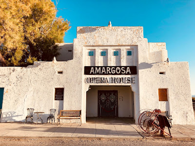


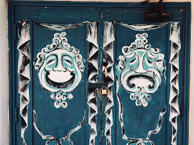

Left: Amargosa Opera House Theater entrance. Center left: Amargosa Opera House outdoor corridor. Center: Amargosa Opera House Hotel Room 22, Red Skelton's room. Center right: Mask design on the doors of Amargosa Opera House Theater. Right: Amargosa Opera House Theater inside.
Wildcat Trail in Monument Valley
The big attraction of Monument Valley is the famous 17 mi – 27 km “Valley Drive”. The route’s opening hours vary by season; in the winter season (includes April) the drive opens at 8:00 am. (There is a gate at the entrance/exit of the drive.) We arrived at the route around 6:00 am and to kill time, we decided to walk Wildcat Trail as the sun rose. The trail is a relatively easy hike at 3.3 m - 5.3 km, which we walked leisurely in about two hours. The Wildcat Trail takes around the West Mitten Butte. Walking the trail was an unexpected highlight for us.
By the way, the Monument “Valley Drive” can be easily done in most cars. We did it in a Nissan Qwest Minivan. There is a part at the start and end of the route (it’s a loop) that is steep. We saw a few people get stuck when they went too slow. They made it out eventually after a few tries.
By the way, the Monument “Valley Drive” can be easily done in most cars. We did it in a Nissan Qwest Minivan. There is a part at the start and end of the route (it’s a loop) that is steep. We saw a few people get stuck when they went too slow. They made it out eventually after a few tries.
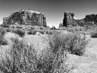

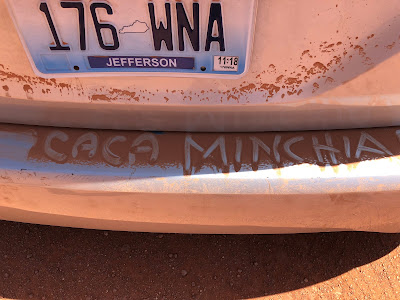


Left: Monument Valley from Valley Drive. Center Left: View from Wildcat Trail at sunrise, Monument Valley. Center: An invented Italian swear word written in the dust on the back of our van on the Valley Drive in Monument Valley. Center Right: Zion National Park - North Folk Virgin River. Right: Hackberry General Store on Route 66.
Death Valley National Park
For the most part, we visited the southern part of the park and we were happy with our route. We stayed in Death Valley Junction (Amargosa Hotel) and entered the park from the east along route 190 to Furnace Creek where we went south to Badwater. From Badwater, we backtracked north to Furnace Creek, picking up 190 again to exit the park toward Panamint Springs. Along the way we saw all the typical sights listed above. We spent the most time at Badwater basin, walking ½ mile out from the parking lot and back. It was about 94 degrees when we visited. Don’t forget to bring hat and sunscreen! An umbrella to block the sun isn’t a bad idea either.
It’s worth a stop at the Furnace Creek ranger station and get maps and information.
The most northern feature of the park we saw was Mesquite Flat Sand Dunes. Therefore, we didn’t see any of the northern parts of the park including the Racetrack (moving rocks), Scotty’s Castle (it was closed for repairs), or Ubehebe Crater.


Left: Death Valley - Badwater Basin. Center: Death Valley - Mesquite Flat Sand Dunes. Right: Death Valley - Ballarat Ghost Town.
Grand Canyon South Rim
Exploring the south rim is possible in a day with easy walking options east or west from Mather Point. We parked and then explored on foot and by park bus. We didn’t think about renting bikes, but that would have been an interesting way to go because there are trails along the rim and slightly inland that would be fun to ride along.
Specifically, we parked at Grand Canyon Visitor Center. Walked around Mather Point and then east towards South Kaibab Trail. We took the bus back to the visitor center and then drove to Grand Canyon Village to explore some more on foot and eat at late lunch at El Tovar. We probably should have just left the car in one spot and made more use of the Grand Canyon bus system – it would have been easier.
Note: Grand Canyon Skywalk – the suspended glass bridge – is much farther west than Grand Canyon Village, what is generally called the South Rim. The skywalk is located on Hualapai Tribe reservation and is only 120 miles from Las Vegas. Therefore, it’s an easy day trip from Las Vegas. Grand Canyon Village on the other hand is 270 miles from Las Vegas, representing more of an investment in time to reach. We struggled with the decision to stop and see the skywalk or not. In the end, we decided that the thrill of walking over the glass-floored bridge wasn’t that much of a draw for us and so we skipped it.
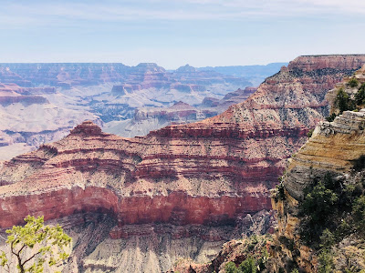


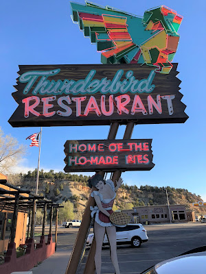
From left to right: View of Yaki Point from the Grand Canyon South Rim Trail; View from Desert View Watchtower, Grand Canyon; Inside the Desert View Watchtower; Inside Grand Canyon Caverns; Dinosaur footprint north of Kanab; The Thunderbird Lodge Sign - Home of Ho-made Pies (The name came about because there wasn't enough space on the sign to fit all the letters way before the current meaning of "ho".)
The Open Road
In 7th grade I painted a scene of a desert with a road winding through it. I had never been to the desert, but it represented a magical place, a place of escape and freedom. And that still seems to be the case because on this trip, I found the road stretching out before us endlessly fascinating. Our routing took us through different types of desert, each with its own subtle differences.
"Get your motor runnin'
Head out on the highway
Lookin' for adventure
And whatever comes our way" Born to Be Wild


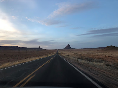

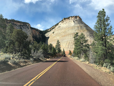


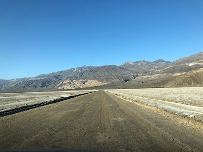


Shots of the open road, except the last image which is of a Venice Beach canal.
Top row, left to right: On Route 66 Near Grand Canyon Caverns; Outside of Tuba City; Approaching Monument Valley at Dusk; Route 89 West of Lake Powell; Entering Zion National Park from the East; Amargosa Valley looking south along route 373; Death Valley Route 190 heading toward Zabriskie Point; Artist Dr Death Valley.
Bottom row, left to right: Artists Rd Beginning - Death Valley; Artists Rd End - Death Valley; Badwater Rd Heading North Toward Furnace Creek; Trona Wildrose Road Looking South; Ballarat Rd Heading Northeast; South near San Fernando, heading into the metropolis of Los Angeles; Venice Beach Canal
Next Time
There is always a next time when it comes to travel. Is there travel without regrets? Maybe, but we haven’t found it yet. Most of our regrets stem from not having enough time to properly explore.
Stay in Boulder City
To be close to family, we stayed at Railroad Pass. Next time, we would try the Boulder City Hotel. There is no gambling in Boulder City, the main street a fun stroll, and there are good dining options.
More Time in Zion
More Time in Zion
Visiting Zion in a day was simply not enough. Even if you are not going to hike or you are just going to do a few simple walks – as we did – you can’t do it all in one day and see all the interesting parts including museums. There is a frequent and easy-to-use bus that takes you into the main "park" drive. We did not do the famous Angel's Landing Trail and would have liked to tackle part of that, at least up to Walter’s Wiggles but time-wise we couldn’t. Also, on the way to Zion from the east we saw signs for Coral Pink Sand Dunes National Park that piqued our curiosity.
One More Day in Page Arizona
One More Day in Page Arizona
We had originally planned to spend two nights in Page and skip Monument Valley altogether, partly as a break from the string of one-nighters and partly because there was a lot to do in Page. In the end, we did Monument Valley and just one night in Page. If we had had a few extra days in our itinerary, I would add one more night to Page.
Death Valley
Death Valley
We didn’t make it north to visit the crater or the moving rocks. In addition, an extra day in the area would have given us more time for some light hiking, e.g., walking into Artist’s Palette and Golden Canyon Interpretive Trail rather than just looking at them from the road or an observation point.
Searles Valley
Searles Valley
After driving around and through Death Valley, our hotel for the night was in Mojave, California. On our way there, we passed through Searles Valley at dusk. I don’t know, maybe it was the light but the town seemed interesting. I wanted to stop and find out more about all the industry and piping over the dried lake bed. Not until much later did I have an opportunity to read about it and learn about its fascinating history. There is a roadside plaque here that you can stop and take a break at. Nearby are the Trona Pinnacles named after the mineral of the same name, trona, a non-marine evaporite and the backdrop of a number of sci-fi movies.
Brochures and Maps
Here is a small sampling of the brochures, maps, and other items we picked up during the trip. You all know I'm a pack-rat tourist.


Death Valley National Park Brochure and Map


Monument Valley Navajo Tribal Park Brochure with Map of Valley Drive


Left to Right: Tusayan Arizona Business Map; Southern Utah Area Park Map; Page Area Map Showing Driving Route from Navajo Nation LeChee Chapter to Waterholes Trailhead; Waterholes Canyon Hike Map; Example of Navajo Nation Backcountry Use Permit


Left and Center Left: Grand Canyon National Park Overview Maps. Center Right and Right: Grand Canyon Pocket Map.


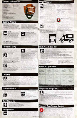
Left and Center Left: Hiking into Grand Canyon Brochure. Center Right and Right: Zion National Park Information Sheet.
No comments:
Post a Comment
All comments are moderated. If your comment doesn't appear right away, it was likely accepted. Check back in a day if you asked a question.