

Left: Route from Rifugio Tolazzio to Passo Volaia and on to Rauchkofel. Right: View west after coming down from Rauchkofel.
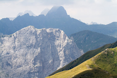


Left three images: Views of and from Monte Rauchkofel including view of Lago Volaia. Right image: Stencil on the wal of Rifugio Lambertenghi-Romanin.
Overview
Length: 11 km (6.8 miles)
Duration: 6 hours walking + 1 hour for lunch
Elevation: Starting and minimum elevation Rifugio Tolazzi @ 1.370 m (4,494 feet), maximum elevation Monte Rauchkofel @ 2460 m (8,070 feet)
Location: Italy, Friuli-Venezia Giulia, Udine, Plan di Val di Bos and Austria, Lesachtal
Hike Details
I was drawn to this hike because it seemed like it would be fun to cross the border from Italy to Austria while hiking, have lunch, and return. What’s more, we were in Udine for a few days where the weather was hot, hot, hot, so a day in the mountains seemed like a good idea. Why sweat it out in the Friulian plain when the mountains were beckoning?
This hike took us by three rifugi (or mountain huts), Tolazzi (starting point in Italy), Rifugio Lambertenghi-Romanin (still in Italy, just before the lake), and Wolayerseehütte (Austria, on the other side of the lake). The lake at the pass is called Lago Volaia in Italian and Wolayasee in German.
The hike is in the Carnic Alps (le Alpi Carniche). The word Carnic likely comes from the Roman name for this area, which in turn likely came from the name of the tribe that once inhabited this area and The tribe also lends its name to the Carnian age/stage in the Triassic period.
We arrived at the start of the hike (Rifugio Tolazzi) in car from Udine. From the parking lot of Tolazzi to the pass, it’s a bit of a slog on sentiero n° 144, but things pick up once you reach Rifugio Lambertenghi because in only a few more meters you reach the pass and the beautiful Lago Volaia. We went around the west side of the lake to reach Wolayerseehütte, where we ate lunch. After lunch, we continued east around the north end of the lake on our way to Monte Rauchkofel, following for a while the Geotrail Wolayersee before splitting off and heading to the peak (OAV 438). After the Rauchkofel peak, we came back down and joined up with the Geotrail again for a bit heading to Valentintörl, a pass at 2138 m. On this trail, OAV 437, there are some cables and handholds that are useful for some steep sections. From the Valentintörl pass, it was back to the east side of the lake and back to Rifugio Lambertenghi to start the final descent.
Despite the satellite images included in this post showing snow on the trail, we did not run into any snow at this time of the year.
If you have time or you don’t want to climb Rauchkopfel, you could spend some time exploring the signs of World War I around the lake as explained in the Itinerari della Grande Guerra site. World War I is associated with trench warfare, and on Passo Volaia you can explore a recovered WWI trench on the south end of the lake. In fact, CAI trail 144 bring you right into the middle of the trench from where you can go east or west inside the trench. The prominent war monuments on either end of the lake are the Monument to the Carinthian Volunteers, north of the lake, and an iron cross and stone altar, south of the lake. Carinthia refers to the southernmost Austrian state. The rifugio Lambertenghi-Romanin is dedicated to two soldiers who died at the pass during WWI.
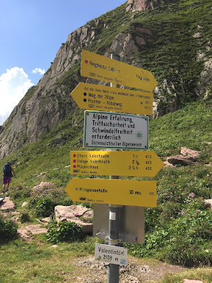


Left: Signage at Valentintörl Pass. Center: Sign near the Wolayerseehütte showing start of Geotrail. Right: List of stops on the Wolayersee Geotrail.
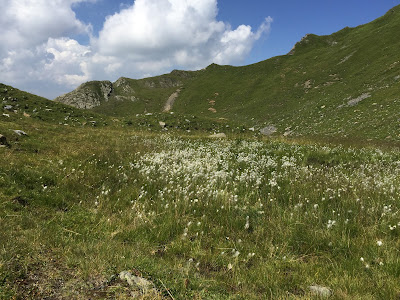


Left: High meadow view near Rauchkofel with the white of Eriophorum or cottongrass. Center: High meadow view near Rauchkofel with the genera Rumex, Aconitum, and Adenostyles. Right: View from Valentintörl toward the backside of Coglians - Hohe Warte group.


Left and center: Trail and wildflowers with view looking west. Right: Another view of the hike, annotated.


Left: Bratwurst, sauerkraut, grated horseradish, and potato lunch at Wolayerseehütte. Right: Dessert, a type of strudel, at Wolayerseehütte.
Flora
A list of species that is useful for the Alpi Carniche can be found at Sistema informativo sulla flora delle Alpi Carniche meridionali (Ampezzo-Sauris) and the Checklist Flora per Regione.Key: [Family] Genus species – Common name in English (Common name in Italian)
[Asteraceae] Cirsium erisithales – Yellow Thistle (Cardo zampa d'orso)
[Asteraceae] Hieracium aurantiacum – Orange Hawkweed (Sparviere aureo)
[Campanulaceae] Phyteuma hemisphaericum – Globe Headed Rampion (Raponzolo alpino)
[Cyperaceae] Eriophorum sp. – Cottongrass (Pennachi)
[Gentianaceae] Genzianella campestre – Field Gentian
[Gentianaceae] Genzianella germanica – Chiltern Gentian (Genzianella delle Alpi Retiche)
[Orobanchaceae] Euphrasia officinalis – Eyebright (Eufrasia officinale)
[Papaveraceae] Papaver aurantiacum – Rhaetian Poppy (Papavero delle Alpi Retiche)
[Ranunculaceae] Aconitum lycoctonum – Wolfsbane (Aconito lupaia)
[Saxifragaceae] Saxifraga aizoides – Yellow Saxifrage (Sassifraga gialla)


Left: Cirsium erisithales – Yellow Thistle (Cardo zampa d'orso). Center: Hieracium aurantiacum – Orange Hawkweed (Sparviere aureo). Thistle with hoverfly, likely genus Eristalis.

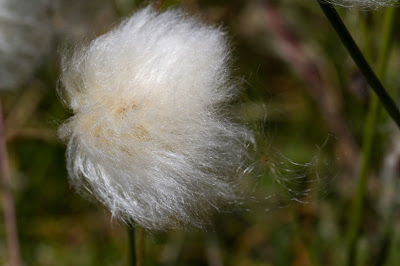

Left: Needles of a conifer. Center: Eriophorum sp. - Cottongrass head. Right: Euphrasia officinalis – Eyebright (Eufrasia officinale).


Left: Genzianella germanica – Chiltern Gentian (Genzianella delle Alpi Retiche). Center: LikelyGenzianella campestre – Field Gentian with four petals. However, I've seen G. germanica with flowers having four and five petals on the same plant. Right: Phyteuma hemisphaericum – Globe Headed Rampion (Raponzolo alpino).
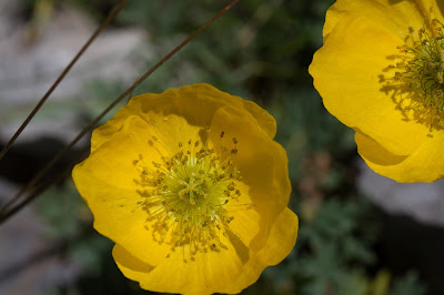


Left and center: Papaver aurantiacum – Rhaetian Poppy (Papavero delle Alpi Retiche). Right: Aconitum lycoctonum – Wolfsbane (Aconito lupaia).


Left: Salt encrustations on Saxifrage leaves. Right: Saxifraga aizoides – Yellow Saxifrage (Sassifraga gialla).
No comments:
Post a Comment
All comments are moderated. If your comment doesn't appear right away, it was likely accepted. Check back in a day if you asked a question.