Saturday, August 20, 2016

Bolzano to Innsbruck – Street Sign Language Lesson IX

previous lesson | this lesson | next lesson

For this episode of street sign language lessons, we draw examples from a recent trip we took north through Austria and southern Germany. Our first stop was Innsbruck where many of these photos were taken. The official language in Austria is of course German, but you’ll find lots of signs that include Italian translations, especially in cities close to Italy. In fact, signs start featuring German and Italian well before you leave Italy. Two of the examples shown were taken near Bolzano.

In this post you’ll learn about towing trailers on the A22, read about my love affair with stube, learn how to say sunny in Italian, see a statue that has been touched too much in its private parts, and discover how life is like a ski jump. What are you waiting for? Keep reading.

Sign on the A22 Autostrada

Divieto di sorpasso per veicoli trainanti i rimorchi – No passing for vehicles towing a motor home or trailer
This sign was one of many we saw on the A22 Autostrada del Brennero as we headed north reminding drivers that vehicles towing a load cannot pass. (The rules governing passing are more complicated than shown here and depend on tonnage and location on the road.) The interesting words here are rimorchio / rimorchi meaning trailer or load and trainanti from trainare, to pull or tow.

BTW: If you are driving north from Italy into Austria, don’t forget to purchase and affix an Austrian vignette to your windshield. You can buy them at many spots before you reach the border. If you don’t have one on an Austrian highway, you will get a ticket.

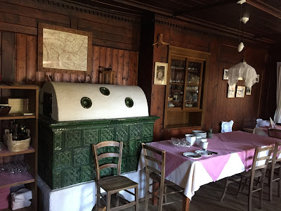
Left: Stube in Albergo Signaterof. Center and right: Sign for Stube aus Caldes bei Malè example in Tiroler Volkskunstmuseum
Stube in Albergo SignaterofSign for Stube aus Caldes bei Malè example in Tiroler VolkskunstmuseumSign for Stube aus Caldes bei Malè example in Tiroler Volkskunstmuseum

Left: Sign indicating location of stube in Albergo Signaterof. Center: Canederli (knödel) with chanterelles (finferli) at Albergo Signaterof. Right: Dish of testina at Albergo Signaterof.
Sign indicating location of stube in Albergo SignaterofCanederli (knödel) with chanterelles (finferli) at Albergo SignaterofDish of testina at Albergo Signaterof

Stube al 1 piano – The stube is on the first floor
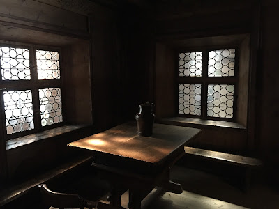
I am fascinated with stubes, a type of traditional living room found in the Tyrol area. A stube is room lined with wood, with a low ceiling and usually containing a stove. We first experienced them in 2008 (see Ladin Mugums and Stuas) on our first trip in the Dolomites. To me, the rooms are like cozy studies where you can immerse yourself for hours reading or hiding from the world.

While we are dining at Albergo Signaterhof (above Bolzano) on our way north to Innsbruck, I see the sign and I remember the feel and smell of stubes. After a lunch of testina and canederli (knödel) with chanterelles (finferli), we check out the stube at Albergo Signaterhof. It’s satisfying, but even more satisfying is the fascinating collection of recreated stube we would see a few days later in the Tiroler Volkskunstmuseum in Innsbruck.

Weather for Innsbruck


Prevalentemente soleggiato – Mostly sunny
Switching the language on your phone is a good exercise to learn new words. Here is a screen capture from the weather app on my phone showing the weather for Innsbruck. (Perfect weather for a hike that we did: Hike in Innsbruck: Hafelekarhaus to Pfeishütte.) I was in the habit of saying c’è sole to indicate it was sunny out when the better way to say it is with the word soleggiato.

Sign at Albergo Signaterhof asking customers to chip in some money if they are just using the bathroom.
Sign at Albergo Signaterhof asking customers to chip in some money if they are just using the bathroom

Se si utilizza il WC senza consumo vi chiediamo di pagare € 0,50 al bar (carta, corrente, acqua). Ringrazio per la vostra comprensione – If you use the bathroom without buying something we ask that you pay 50 cents at the bar (for paper, electricity, and water). Thanks for your understanding.
We saw this sign at Albergo Signaterhof (above Bolzano) on our lunch stop during a trip north to Innsbruck. Resources are precious here and while it’s nice that you can use the bathroom (for example as a biker just passing through), you should contribute a little to keep it running if you aren’t buying something.

Sign and statues in Hofkirche, Innsbruck.
Sign and statues in Hofkirche in InnsbruckStatue of Rodolf I of Germany, Hofkircke

Si prega non toccare le statue – Please do not touch the statues
It’s hard not to want to touch the statues in the Hofkirche (Court Church) in Innsbruck. They statues depict historical figures that are bigger than life in both senses. One statue in particular, Rodolf I of Germany, has been touched quite a bit in his private area judging by how polished that part of his body is.

Bergisel Ski Jump in Innsbruck. Left: Sign describing the judges' tower. Center: View of ski jump from below. Right: View of ski jump from the top.
Bergisel Ski Jump: sign how ski jumps are judgedBergisel Ski Jump: view from the bottomBergisel Ski Jump: view from the top

Portamento, stile, lunghezza, e atterraggio – posture, style, length, and landing
This sign was at the Bergisel Ski Jump (called trampolino in Italian). The sign describes the judge tower and the criteria on which ski jumpers are judged.

The jump is located just south of the city, an easy 45-minute walk from center and was used in the 1964 and 1976 Winter Olympics held in Innsbruck. The ramp and stylish tower that is the launch point, and today contains a restaurant and observation deck, was designed by Zaha Hadid.

Philosophical musing: life is like a ski jump. You get judged on how you behave (posture - portamento), your style (stile), how long you live (lunghezza), and how you die (stretching it a bit, your landing or atterraggio).

Trash can  in Innsbruck with a play on Italian and German words.
Trash can  in Innsbruck with play on Italian and German words

Mülle grazie – Trash, thanks
Mülle is trash in German. In an effort to make trash cool, catchy slogans, often a play on words, are being used in Berlin (BSR) to make people think about their trash and disposing of it. Mülle grazie is a take on mille grazie, or thank you very much. Perhaps, Innsbruck seems to have adopted a similar approach, which might explain why we saw the phrase there.

Friday, August 19, 2016

Hiking near Schönwald im Schwarzwald, Black Forest

Left: View of the hike route in Google Earth. Right: View of Schönwald im Schwarzwald
View of the hike route in Google EarthView of Schönwald im Schwarzwald

Hike Notes

Length: 22.2 km (13.8 miles) round-trip
Duration: 7.5 hours inclusive of a 2-hour lunch and many stops to look at scenery
Elevation: 690 m (2,264 feet) total elevation gain, min elevation 953 m (3,127 feet), max elevation 1151 m (3,776 feet)
Location: Germany, Baden-Württemberg (state), Freiburg (region), Schwarzwald-Baar-Kreis (district)

Overview

This hike in the Black Forest (central part) was as described in the Cicerone Guide: Hiking and Biking in the Black Forest by Kat Morgenstern, Walk 10: To the source of the Danube. As part of the purchase of the book, I logged on to the Cicerone site and downloaded the GPX route files. We followed the GPX route for this walk (more or less) because it was easier than trying to follow the written cues in the hike description. Even then, we seemed to veer off path every now and then. However, it was hard to get lost on this hike.

Aside on mapping applications
Thank you Maps.me for just working. And, a black eye for my Google Maps application (iPhone), which proved just about worthless in spotty connectivity, which was most of this hike. In fact, I've been moving more toward using applications like Maps.me with good offline capabilities in difficult, complicated navigation situations. 
In general, I find that Google Maps throws up lots of information that is confusing. Case in point: driving down the road, Google Maps suggested (alternate route) we get off the main road we were on, drive down a side road for about 1 km, turn around and come back and resume traveling on the main road. In other words: a useless suggestion. In other situations, it picks routes (at least in Germany and Italy in our experiences) that may save a few seconds under optimal conditions but are clearly poor choices in general. Some of our recent experiences have reiterated the need for me (as navigator usually) to be diligent about checking routes and overriding suggested ones from an application using common sense. Duh, right? For example, when driving into an historical center, it is generally better to follow the routing suggested by the street signs ("centro") and not some crazy-side-side-street option that may look good at first glance in a mapping application but will get you in trouble in the end. (As happened to us in Sulmona a few months ago.)
A positive point for Google Maps is that we find its voice instructions to be the best we've used. At key decision points on the route, it lets you know what to do in language that is very clear.
It’s useful to know before you go a little about the way trails are marked in the very comprehensive trail system of the Black Forest. (The Cicerone guide gives a good overview.) The basic thing you need to know is that a yellow rhombus (or diamond) designates a local path, a blue rhombus a longer, trans-regional route, and a red rhombus a main trail. During this hike (Walk 10), you pop on and off all three types of trails.

Before the hike we had an expectation of the Black Forest as you might find as the setting of a dark fairy tale: deep and impenetrable. This hike was not at all like that. It was more of a walk out of town, through some managed forest lands, skirting fields and farms, and ambling along some country lanes kind of walk. That’s not bad at all, and we enjoyed the walk thoroughly, but you should adjust expectations accordingly. There are likely wilder and more remote hikes you could do in the Black Forest – in particular, in the southern part – but this wasn’t one of them. That said, the hike is a a great introduction to the area.

A good example of the scenery is the view from Brendturm (tower), where you look over forest and farms. Note the number of wind turbines. The turbines and neat-as-a-pin barns with solar panels on top make it seem like we were walking through a bit of utopia. And, well, maybe we were.

Some of the main sights on this hike:
  • Blindensee – A rain fed moor.
  • Start of the River Breg, the primary headstream of the Danube River (next to Kolmenhof).
  • Günterfelsen – Gunter rock formation are large boulders released from the soil by prehistoric glaciers; the formation is part of what you see in Walk 10.
There are a number of places to eat located around Martinskapelle and Brend, which the guide lists. We ate at Höhengasthaus Kolmenhof an der Donauquelle und St. Martinskapelle. We had pan-fried trout that was scooped out of the holding tank on the patio, and a cutting board sampler of Black Forest meats. The meat sampler came with a shot glass of Schnapps: the waitress said that after so much meat, you need the Schnapps. We finished with – you guessed it – a Black Forest cake.

On this trip, we were based in Tübingen and drove to Schönwald (hike start). Tübingen isn’t the greatest base for hikes in the Black Forest because of the distance you need to drive to get to hikes, at least ones in the Cicerone guide we used. If we were to focus only on hiking in the Black Forest, we would pick one of the areas (north, central, south) and base ourselves there. As it was, we had more than enough to do in Tübingen, and the day trip to the Black Forest was to get an idea of the area for a future visit.

Plants

The plants we saw on this hike reminded me a lot of the what I saw on the Wainwright Coast to Coast walk (part1 and part2). It really was the invasive Himalayan Balsam that was the first plant that I recognized, followed by Meadowsweet, Loosestrife, and Eyebright.

Here's a list of some plants we saw. Images are below.

[Asteraceae] Achillea ptarmica – Sneezewort
[Asteraceae] Cirsium arvense – Creeping Thistle
[Asteraceae] Hieracium aurantiacum – Orange Hawkweed, Devil’s Paintbrush.
[Balsaminaceae] Impatiens glandulifera – Indian Balsam
[Balsaminaceae] Impatiens noli-tangere – Touch-me-not Balsam
[Caryophyllaceae] Dianthus armeria  – Grass Pink
[Caprifoliaceae] Succisa  – Scabious
[Lamiaceae] Prunella vulgaris – Common Self-heal
[Onagraceae] Epilobium
[Orchidaceae] Epipactis helleborineBroad-leaved helleborine
[Orobanchaceae] Euphrasia officinalis – Eyebright
[Plantaginaceae] Digitalis
[Primulaceae] Lysimachia vulgaris – Common Loosestrife
[Rosaceae] Filipendula ulmaria - Meadowsweet
[Rosaceae] Rubus - Raspberry

Eating at Höhengasthaus Kolmenhof: Black Forest cake, a cutting board of local cured meats and cheeses, fresh trout, and coffee.


Left: Maps.me view of the route. Right: Information about the Blindensee Moor.Maps.me view of the routeInformation about the Blindensee Moor

Left: Green insect on Succisa – scabious. Center: Prunella vulgaris – Common Self-heal. Right: Epipactis helleborine – Broad-leaved helleborine
Green insect on Succisa – scabiousPrunella vulgaris – Common Self-healEpipactis helleborine – Broad-leaved helleborine

Pilosella aurantiacum – Orange Hawkweed, Devil’s Paintbrush
Hieracium aurantiacum – Orange Hawkweed, Devil’s PaintbrushHieracium aurantiacum – Orange Hawkweed, Devil’s Paintbrush

Left and center: Lysimachia vulgaris – Common Loosestrife. Right: Managed forest near Schönwald.
Lysimachia vulgaris – Common LoosestrifeLysimachia vulgaris – Common LoosestrifeExample of Black Forest trees near Schonwald

Impatiens noli-tangere. Flowers and leaf with worm.


Left: Filipendula ulmaria - Meadowsweet. Center and right: Euphrasia officinalis – Eyebright.
Filipendula ulmaria - MeadowsweetEuphrasia officinalis – EyebrightEuphrasia officinalis – Eyebright

Cirsium arvense and Impatiens glandulifera.
Cirsium arvense and Impatiens glandulifera.Cirsium arvenseImpatiens glandulifera

Left: Dianthus armeria - Grass Pink. Right: Digitalis - Foxglove
Dianthus armeria - Grass PinkDigitalis - Foxglove

Left: Achillea ptarmica – Sneezewort. Right: Rubus - Raspberry.
Achillea ptarmica – SneezewortRubus - Raspberry

Left: View coming into Schönwald im Schwarzwald. Right: Typical forest road you walk over.


Left: Skirting a field. Right: View of hills and farmland.


Left and center: Günterfelsen - Gunter Rock formation. Right: Hunting hide that is common sight at forest edge.
Günterfelsen - Gunter Rock formationGünterfelsen - Gunter Rock formationHunting hide that is common sight at forest edge