Monday, September 8, 2014

Camp Muir Hike

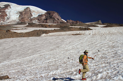
Upper Left: View from Skyline Trail Toward Muir Snowfield; Upper Right: Camp Muir Looking West; Lower Left: Our Route Up and Back; Lower Left: On the Muir Snowfield, A Hiker Alongside a Glissade Path
View from Skyline Trail Toward Muir SnowfieldCamp Muir Looking WestOur Route Up and BackOn the Muir Snowfield, A Hiker Alongside a Glissade Path

Hike Notes
Length: 10.7 miles (according to our Garmin HCX)
Duration: 7.25 hours (8:15 am – 3:30 pm), includes 60 min lunch break at the camp
Elevation Gain: 4,680 ft. (total), 10,080 ft. max elevation at Camp Muir, starting @ Paradise 5,400 ft.
Location: Mt. Rainier

For our seventh hike of the summer 2014 (and bringing us to 95.5 total miles), we hoofed it up to Camp Muir (WTA site). Some observations:

  • On this September day, it was warm. We hiked almost the whole time in short sleeves, except when we sat down for lunch.
  • We didn’t hit snow until something like 8,000 feet and even then, if you wanted, you could stay off the snow for a bit longer. However, we found it was actually easier to just get on the snow and start walking rather than avoid it.
  • We used trekking poles and KAHTOOLA MICRO spikes that were more than adequate for this hike on this day. These micro spikes were easy to pull on and off and much better than walking without them.
  • We started early and saw almost nobody going up (preferable). On the way down we saw a boatload of people heading up. The analogy of a line of ants going to a sugar bowl (Camp Muir) would not be out of place.
  • The snow was much more slushy on our way down, which is okay for going down but perhaps isn’t fun when climbing up.
  • There was just one “tricky” spot in the snowfield (near the top) that was icy with small (very narrow) “crevasses”. There were flags to warn you and paths over the crevasses were obvious. Still, don’t take them lightly.
  • Yes, we brought trash bags to slide down (glissade) and we did. Bring heavy duty bags. Better yet, bring waterproof pants, slip them on, and just go down like that. Most people on the way up just stared at us with blank faces as we slid past them. We weren’t sure if they were annoyed or wishing they had an earlier start.
  • I was expecting Camp Muir to be more extensive, with more places to sit and take in the view. That really isn’t the case, it’s just a dry ridge divides the Muir snowfield from the Cowlitz Glacier. Most of the climbers the day we there were sprawled out on the main level of the ridge, which left the upper level for the day hikers. It’s near the bathroom where you’ll catch a whiff or two. You can’t explore any more further past the ridge without being tied together – at least that’s what a sign said.
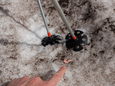
  • While the Muir snowfield seemed free of litter, I was surprised at number of pieces of gum we spotted, especially the bright pink and greens. People: swallow the gum or put it a piece of paper in your pocket.

In the Google Earth image of the trail included with this post, it shows that we followed one part of the Skyline Trail up to the turn off to Muir and followed a different part of it back to Paradise.


Meadow Along Skyline Trail
Meadow Along Skyline TrailMeadow Along Skyline Trail

Left: View Looking North, Meadow to Snowfield to Mount Rainier; Right: Sign at Turnoff to Pebble Creek
View Looking North, Meadow to Snowfield to Mount RainierSign at Turnoff to Pebble Creek

Left: Small Crevasse in Muir Snowfield; Right: One of Many Gum Sightings – People, Really?
Small Crevasse in Muir SnowfieldOne of Many Gum Sightings – People, Really?

Left: Nisqually-Wilson Glacier – The Muir Snowfield is to the Right of That; Right: View from Camp Muir Looking South, Over Paradise Lodge Where the Hike StartedNisqually-Wilson Glacier – The Muir Snowfield is to the Right of ThatView from Camp Muir Looking South, Over Paradise Lodge Where the Hike Started

Left: Starting Walk Up Muir Snowfield; Right: Coming Down Muir Snowfield Using Butt Glissading
Starting Walk Up Muir SnowfieldComing Down Muir Snowfield Using Butt Glissading

Left: Another 1,000 Or So Feet To Go to Get to Camp Muir; Right: View from Skyline Trail Looking North Toward Rainier
Another 1,000 Or So Feet To Go to Get to Camp MuirView from Skyline Trail Looking North Toward Rainier

Sunday, August 24, 2014

Yellow Aster Butte and Tomyhoi Lake Hike

Left: Hike Profile KML from Canon GPS Logger; Right: View of Tomyhoi Lake
Hike Profile KML from Canon GPS LoggerView of Tomyhoi Lake
Hike Notes
Length: 12.3 miles (according to *Garmin HCX)
Duration: 8.25 hours (8:15 am – 4:30 pm)
Elevation Gain: 4,361 (total), 6,184 ft max elevation on top of Yellow Aster Butte*, starting @ 3,670 ft
Location: North Cascades – Mount Baker Highway

For our sixth hike of the 2014 summer (and bringing us to 84.8 total miles this season), we chose Yellow Aster Butte (WTA: Yellow Aster Butte, Tomyhoi Lake). We actually went to Tomyhoi lake first and then Yellow Aster Butte. At approximately 1.4 miles from the trailhead, the trail splits and you make your choice: the left route takes you to Yellow Aster Butte, and the right route takes you up over Gold Run Pass and down to Tomyhoi Lake. The path to Yellow Aster Butte is well-beaten and easy to follow. The path to Tomyhoi Lake was bit trickier, we lost it a few times as we busied ourselves with flower pictures. Nearer to the lake, there were many paths to get to the lake edge and you just had to pick one. The lake elevation is close to starting elevation at the trailhead. It’s quite a slog to climb back out to Gold Run Pass.

On the Yellow Aster Butte trail, we encountered a lot of people. Saturday, sunshine, beautiful views, and trail popularity explains it. Not many seem to opt for the Tomyhoi Lake trail, which we found very quiet. Choose wisely.

Selected Plants Observed

Format: [Family] Genus species (Common Name). Links are to WTU Image Collection.

[Asteraceae] Petasites frigidus (Sweet Coltsfoot) – “Petasites is from the Greek petasos ‘a broad-brimmed hat,’ referring to the large basal leaves characteristic of this genus.” [1]
[Liliaceae] Anticlea occidentale (Mountainbells)
[Melanthiaceae] Veratrum viride (Green False Hellebore)
[Orobanchaceae] Castilleja parviflora (Mountain Indian Paintbrush)
[Orobanchaceae] Pedicularis racemosa (Sickletop Lousewort)
[Onagraceae] Chamerion angustifolium (Fireweed)
[Onagraceae] Chamerion latifolium (Broad-Leaved Willowherb)
[Orchidaceae] Platanthera stricta (Slender Bog Orchid)
[Orchidaceae] Goodyera oblongifolia (Western Rattlesnake Plantain)
[Phrymaceae] Erythranthe lewisii (Purple Monkey-Flower). Given as Mimulus lewisii in [1].
[Phrymaceae] Erythranthe guttata (Seep Monkey-Flower). Given as Mimulus guttatus in [1].
[Polygonaceae] Oxyria digyna (Alpine Mountain-Sorrel)
[Ranunculaceae] Anemone occidentalis (Western Pasqueflower)
[Rosaceae] Potentilla flabellifolia (High Mountain Cinquefoil)
[Rosaceae] Rubus spectablis (Salmonberry)
[Saxifragaceae] Leptarrhena pyrolifolia (Leatherleaf Saxifrage)
[Saxifragaceae] Micranthes tolmiei (Tolmie’s or Alpine Saxifrage)

Insects Observed

Pterostichus (Beetle)
Pterophoroidae (Plume Moth)
Pointania californica (Willow Apple Gall Sawfly) Gall [2]
Polygonia[3] (Angel-Winged Butterfly) on Valerian
Speyeria hydaspe?
[3] (Hydaspe Fritillary)

References

[1] Plants of the Pacific Northwest Coast: Washington, Oregon, British Columbia & Alaska
[2] http://bugguide.net/node/view/185043/bgimage
[3] On the checklist for Whatcom County from ButterfliesAndMoths.org.

Left: Plume Moth on Goodyera oblongifolia, near trailhead; Right: Dew drops on Moss, near Tomyhoi Lake
Plume Moth on Goodyera oblongifolia, near trailheadDew drops on Moss, near Tomyhoi Lake

Left: Angel-Winged Butterfly, on the way to Yellow Aster Butte; Right: Fritillary on Veratrum leaf
Angel-Winged Butterfly, on the way to Yellow Aster ButteFritillary on Veratrum leaf

Left: Pterostichus Beetle Near Tomyhoi Lake; Right: Potentilla flabellifolia
Pterostichus Beetle Near Tomyhoi LakePotentilla flabellifolia

Left: Sawfly Gall; Right: Larva Inside Gall
Sawfly GallLarva Inside Gall

Left: Anemone occidentalis (Western Pasqueflower); Right: Anticlea occidentale (Mountainbells)
Anemone occidentalis (Western Pasqueflower)Anticlea occidentale (Mountainbells)

Left: Castilleja parviflora (Mountain Indian Paintbrush); Right: Leptarrhena pyrolifolia (Leatherleaf Saxifrage), both in the wet meadow above Tomyhoi Lake
Castilleja parviflora (Mountain Indian Paintbrush)Leptarrhena pyrolifolia (Leatherleaf Saxifrage)

Fireweeds. Left: Chamerion angustifolium; Right: Chamerion latifolium
Left: Chamerion angustifoliumChamerion latifolium

Monkey-Flowers. Left: Erythranthe lewisii (Purple Monkey-Flower); Right: Erythranthe guttata (Seep Monkey-Flower)
Erythranthe lewisii (Purple Monkey-Flower)Erythranthe guttata (Seep Monkey-Flower)

Left: Micranthes tolmiei (Tolmie’s or Alpine Saxifrage); Right: Oxyria digyna (Alpine Mountain-Sorrel)
Micranthes tolmiei (Tolmie’s or Alpine Saxifrage)Oxyria digyna (Alpine Mountain-Sorrel)

Petasites frigidus
Petasites frigidusPetasites frigidus

Left: Platanthera stricta (Slender Bog Orchid) – near Tomyhoi Lake and smelled like honey!; Right: Valerian Feathery Seed Heads
Platanthera dilatata (White Bog Orchid, Bog Candle)Valerian Feathery Seed Heads

Left: Veratrum viride (Green False Hellebore) Single Flower; Right: Rubus spectablis (Salmonberry) Single Berry
Veratrum viride (Green False Hellebore) Single FlowerRubus spectablis (Salmonberry) Single Berry

Left: Map at Trailhead to Yellow Aster Butte and Tomyhoi Lake; Right: View from Gold Run Pass toward Mt. Larrabee and the American Border Peak
Map at Trailhead to Yellow Aster Butte and Tomyhoi LaView from Gold Run Pass toward Mt. Larrabee and the American Border Peak

View from Yellow Aster Butte toward Tomyhoi PeakView from Yellow Aster Butte toward Tomyhoi Peak

Saturday, August 23, 2014

Binomen Art – Ficus carica

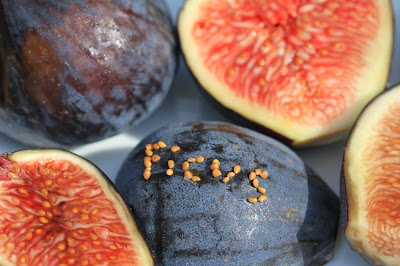
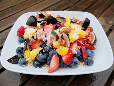
Left: Ficus Spelled Out with Seeds; Right: Morning muesli with Figs. What’s that in my cereal?
Ficus Spelled Out with SeedsMorning muesli with Figs. What’s that in my cereal?
We’ve been enjoying beautiful figs (Ficus carica) with our breakfast muesli and, hey, why not waste a few hours coaxing the little fig seeds into spelling themselves. I confess: I was going to spell out carica, but working with the little fig seeds proved a bit too much before it was time to go to work. The seeds stick everywhere but where I wanted them to. According to the Wikipedia entry on fig pollination and fig fruit, a single fig can contain up to several hundred to several thousand seeds. (You can easily write a small story about figs with that many.) Also, a fig fruit is a multiple fruit composed of many flowers. One way to think about a fig is to take your thumb and index finger and bring the tips close together to almost, but not quite, touch. That’s the fig, an enclosed flower. The little space between your thumb and index finger tips is called the ostiole*. Figs fruits are called syconium, but you won’t see that term in your local grocery store.

* Ostiole makes me think back to time spent at Ostia Antica (Two Days in Ostia Antica). The town is from the Latin ostium, entrance, river mouth.

We also discuss Ficus in Binomen Art - Ficus. In that post it was Ficus microcarpa (Indian Laurel), whose fruit are anything but edible. Microcarpa = small fruit.

Ficus carica seeds
Ficus carica seeds

Friday, August 22, 2014

Binomen Art - Vaccinium

Left: Vaccinium spelled with blueberries; Right: Blueberry cross section.
Vaccinium spelled with blueberriesBlueberry cross section
We’ve got blueberries on our minds and in our mouths. We recently bought a flat at the Fremont Sunday Market, and we’ve been seeing blueberries and their relatives, huckleberries, quite a bit on our hikes in the Cascades. It thus seems right to honor Vaccinium (the genus name for blueberry) in a Binomen Art piece.

Quattrocchi on the origin of Vaccinium:

Vaccinium (Plinius), a Latin name for the blueberry, whortleberry, a corruption of the Greek hyakinthos “the hyacinth, purple, dark red,” Bakinthos; Akkadian bakkitu “professional mourner, paid mourner,” bakku “lachrymose,” bakum, bikitu “lamented”.

Wikipedia says explicitly “It is not the same word as vaccinum ‘of or pertaining to cows.”

The blueberries used in the photos here are from Hayton Farms, and they are set in front of our small blueberry bush (Vaccinium x ‘Sunshine Blue’ - Southern Highbush). Our bush does produce nice berries when we get to them before the blue jays and robins. The blueberries from Hayton Farms are likely Vaccinium corymbosum, the most common commercially grown blueberry. Regardless of where the blueberries come from, they go into a pile of fruit on our morning muesli.

Left: Morning Muesli with Blueberries; Center: Blueberries Close Up; Right: Binomen Art Morning Muesli with BlueberriesBlueberries Close UpBinomen Art