Sunday, September 25, 2016

Sicilia – Street Sign Language Lesson XII

previous lesson | this lesson | next lesson

For this episode of Street Sign Language Lesson, we head to Sicily. Over two weeks, we visited Palermo, several of the Aeolian Islands, and did several hikes around Mount Etna. In this post we talk about signs and words on them that convey a little of the flavor of our trip including ash (cenere) and sand (sabbia) of Etna, pumice (pomice) and obsidian (ossidiana) of Lipari, dressed-up bread (pane cunzato), and (avvistamento incendi) fire lookout.

Around Mount Etna


Fire spotters at Rifugio Citelli.
Avvistamento incendi boschivi – forest fire watch
We had just finished a hike from the Rifugio Citelli to Grotta di Serracozzo and two men in a little shack caught our eye. We just had to see what they were doing. As we walked closer, we saw the writing on the side of the shack that indicates they are keeping an eye out for fires and they explained as much when we asked. They told us that most of the fires are arson, not naturally occurring.

Several days earlier, we were in the Aeolian Islands and the subject of fire came up several times. We’d see land that looked recently scorched (e.g., on Lipari) and we would ask about it. There too, it seemed that the answers we got were that the fires are set deliberately. One person told us it was for hunting. Another person we asked said it was a typical Sicilian revenge tactic.

Just this June there were an unbelievable number of fires across Sicily, now believed to have been arson. See for example, Firefighters in Sicily battle dozens of blazes which officials believe were deliberately lit by the mafia, developers - or even forest rangers and Mafia 'attaching flaming rags to cats' to start Sicily forest fires. Gulp. Gatti piromani – arsonist cats. Behind the fires there is a money motive, it’s just not clear as of yet what it is.

Signs on the roads around Mount Etna warning of volcanic sand and ash.
Signs on the roads around Mount Etna warning of volcanic sand and ash.Signs on the roads around Mount Etna warning of volcanic sand and ash.
cenere vulcanica, sabbia vulcanica – volcanic ash, volcanic sand
We stayed near Milo at B&B Dimora dell’Etna and noticed many signs warning about volcanic sand and ash as we drove around the mountain. First, it’s difficult to appreciate just how big Etna is, and secondly, how the landscape can change in an instant. Volcanic ash and sand can make roads slippery, reduce visibility, not to mention the damage to the car itself.

Mount Etna funivia warning to behave.
A bowl of salt for driving away evil spirits.
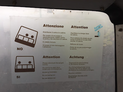
distribuire il carico in cabina – distribute weight evenly in the cabin
We saw this sign on the funivia on the way up to Mount Etna’s summit for a crater summit hike. The image of the tilted cabin made me think of two American lovers riding in a pickup, scrunched over toward on the driver's side of the vehicle. Lovers: please separate.


Vietato oltrepassare questo limite – It is forbidden to go beyond this limit Mount Etna - Vietato oltrepassare questo limite – It is forbidden to go beyond this limit
Vietato oltrepassare questo limite – It is forbidden to go beyond this limit
You cannot go above 3000 m on Etna without a guide, or you could, but it is highly discouraged and foolhardy. Anyhow, why not just go up with a guide and get the experience that goes with that? We were on the summit crater tour when we saw this sign. Later as our group was well beyond the 3000m limit (with our guide) a lone person much lower on the trail seemed to be trying to catch up with us thinking perhaps they could join our group. A park ranger or guide ran after her, yelling, and finally escorted her back down. The person was trying to go it alone.

Oltrepassare is to passare oltre or pass over a limit, limite – masculine – so we use questo.

Lipari


A bowl of salt for driving away evil spirits.
fora malocchio – away with the evil eye
We saw this sign in Chitarra Bar in the old marina of Lipari. For the few days we were in Lipari, we seemed to end up there every morning for an after-breakfast and before-you-start-your-day granita and brioche. Chitarra Bar a great place to watch the tours depart for the day and scuba students getting ready to go out. In the Sicilian language, fora is equivalent to the Italian fuori, or out, as in the exclamation "out!" Malocchio is the evil eye or a hex or jinx. This sign was over a dish of salt where one takes a pinch of salt and throw it over the shoulder to get rid of some bad juju. It’s fairly noticeable (at least for us) the uptick in superstitious beliefs as you travel from north to south in Italy. Here’s one example of a superstitious ritual (see video).

Obsidian and pumice for sale in Lipari.

Obsidian and pumice for sale in Lipari.
ossidiana, pomice – obsidian, pumice
You can’t visit the islands, especially Lipari, without running into these words. They define the islands. Obsidian on Lipari is one of the major deposits in the Mediterranean for this volcanic glass. It was important in the early Neolithic settlements of the islands for creating cutting and piercing tools, and for trading for goods from the mainland (like clay for pottery).

Pumice is another volcanic product that is common on Lipari. There was an important production site for pumice on Lipari, which is now closed. As explained on the site Real House Wife Adventures, the site was closed because of the UNESCO designation that was bestowed on the Aeolian Islands. We also heard this reason when we visited the interesting exhibit inside the Chiesa dell' Immacolata (Castello di Lipari) called “Lipari 1952 – Viaggio nelle cave di pietra pumice - photographs by Cecilia Mangino” running from July 28 to September 10 2016. The young local guy running the exhibition that day echoed the same reason. A double-edged sword: an activity like pumice quarrying that is unique to the island is the very thing that must be curtailed to preserve its status on a World Heritage List. We read that it was because of the dust produced and the pumice debris that clouded the otherwise clear waters. (If you want to read more see the documentation on the UNESCO site for the islands.)

Rescue boat at Coral Beach, Island of Lipari.
salvataggio - rescue
I liked this picture of the boat resting on the beach. nobody needed saving while we were passing by on this calm morning. We rented a scooter and toured Lipari, with a stop here at Coral Beach.

Salina


Restaurant on the Island of Salina advertising pane cunzato.
Pane cunzato – is a cross between a bread salad, open-faced sandwich, and bruschetta; the literal translation is something like “dressed up bread”
We started noticing this Sicilian specialty, pane cunzato, in Lipari when we rolled into town our first night (hydrofoil aliscafo from Palermo to Lipari). We weren’t very hungry but wanted something to snack on. We ate pane cunzato at Il Gabbiano in the old marina. Later, we realized almost every restaurant has a version of pane cunzato.

Vulcano
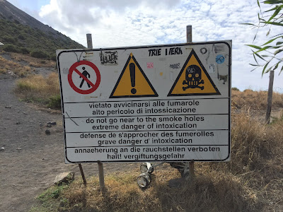

Warning sign at the start of the ascent to the Gran Cratere.
Vietato avvicinarsi alle fumarole alto pericolo di intossicazione – It is forbidden to get close to the fumaroles due to danger of poisoning
It’s easy to read intossicazione as intoxication whereas here it means poisoning.The fumaroles in question are on the Gran Cratere of the Island of Vulcano that we hiked up to. The most that happened to me was I got slightly burned on the leg by gas coming from a fumarole trying to get by an annoying group of French tourists who would not get out of the way and kept shouting “incroyable!” Grrr. Note the baby stroller parked behind the sign.

Inspirational graffiti at the summit of the Gran Cratere on the Island of Vulcano.
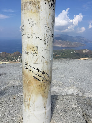
Chi lotta può perdere, chi non lotta ha già perso – forza!
Chi lotta può perdere, chi non lotta ha già perso – forza! – Those who fight can lose, those who don’t have already lost – Onward!
I'm a sucker for inspirational graffiti, I admit it. We saw this written on the high point of Gran Cratere of Vulcano. It’s a crater you can “get to the top of” without a guide as compared to Stromboli and Etna, where you must have a guide. Lottare – to fight or struggle is a useful verb to know.

Stromboli


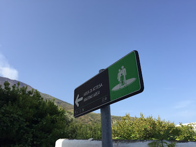
Signs on Stromboli showing which way to go in the event of a tsunami.
via di allontanamento, area di attesa – escape route, waiting area via di allontanamento, area di attesa – escape route, waiting area
via di allontanamento, area di attesa – escape route, waiting area
We were walking along Via Regina Elena on the morning before our hike to the summit, one of the two main streets in Stromboli, and kept seeing these signs. We later learned from our hiking guide that tsunamis are a serious threat as happened in 2002 after the collapse of part of the crater causing a landslide at the Sciara del Fuoco. The wave caused by the material sliding in the ocean reached around the other side of the island causing damage.

We also noticed that these signs are very useful for finding the hidden beaches in Stromboli. Walking along Via Regina Elena, you see a lot of stairs and narrow lanes leading to the sea, but you might be uncertain if they are public or private. If you see these signs, it’s likely a public beach.

Palermo
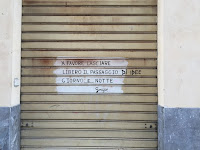

Sign in a driveway in Palermo to leave doorway clear.
x favore lasciare libero il passaggio (di idee) giorno e notte – please leave the doorway clear (of ideas) day and night
x is shorthand for per or "for". I like the way someone tacked on di idee.

Wednesday, September 21, 2016

Mount Etna East Side: Hike from Rifugio Citelli to Grotta di Serracozzo

Left: Hiking route, roundtrip from Rifugio Citelli. Right: Sentiero (trail) 723 Serracozzo.
Hiking route, roundtrip from Rifugio CitelliSentiero (trail) 723 Serracozzo

Hike Notes

Length: 6.8 km
Duration: 3 hours
Elevation: 631 m, 1.733 m at start, 2.167 m at max
Location: Italy, Region of Sicilia, Province of Catania, Etna East, Sant’Alfio

Overview

This was our last hike of our Sicilian trip, a cool and gray day. You can never tell with Mount Etna. We were actually happy for the weather, which added heightened the already the surreal landscape of the Serracozzo. At times we thought we were in Iceland.

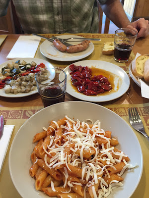
The hike is well-documented on the Etna Tracking site, where you can download GPS tracks. We first followed the indications for La Grotta di Seracozzo and then continued on to make a clockwise loop back to the rifugio following the Sentiero di Serracozzo. The Rifugio Citelli is on the Strada Regionale Mareneve road and easy to get to. After the hike, we had a nice lunch at the rifugio.

Plants and Landscape

Soon after leaving the rifugio parking lot (heading west), you find yourself walking within beautiful birch stands, [Betulaceae] Betula aetnensis - “betula dell’Etna”. Contorted, cream-colored trunks stand out against the black volcanic rock and soil. This birch is endemic to the east side of Mount Etna’s lava terrain.

After passing out of the birch stands, you start to notice strange mounds. Moving closer, you’ll notice they are not quite so soft and inviting as they seem from afar; they have nasty spines. These mounds are [Fabaceae] Astracantha sicula - “spino santo” or “astrogalo siciliano”. This pea family plant is, like the birch, only found only on Mount Etna.

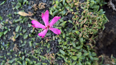
Finally, at this time of year we saw a lot of spent [Asteraceae] Tanacetum siculum flowers and just a few still-in-bloom [Caryophyllaceae] Saponaria sicula, both endemic to Sicily. The species name sicula and siculum means “of Sicily”.

Astracantha sicula
Astracantha siculaAstracantha sicula

Left: Mounds of Astracantha sicula on Serracozzo. Right: Astracantha sicula pushing up through lava rock.
Mounds of Astracantha sicula on SerracozzoAstracantha sicula pushing up through lava rock

Betula aetnensis - “betula dell’Etna”
Betula aetnensis - “betula dell’Etna”Betula aetnensis - “betula dell’Etna”

Left: Saponaria sicula flower. Right: A type of stone called in dialect pietra cicirara, or "chickpea stone".
Saponaria sicula flowerA type of stone called in dialect pietra cicirara, or "chickpea stone"

Left: Map showing three Etna hikes we took. Right: Lunch at Rifugio Citelli.
Map showing three Etna hikes we tookLunch at Rifugio Citelli

Left: View into Valle del Bove from Sentiero 723. Right: Slip sliding down the hill back to Rifugio Citelli, visible in the distance.
View into Valle del Bove from Sentiero 723Slip sliding down the hill back to Rifugio Citelli, visible in the distance

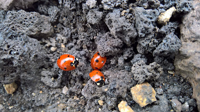
Left: Fluorescent greens of grasses and Astracantha sicula along the trail. Right: Ladybird beetles (or Ladybugs) huddling in the lava on the Serracozzo.
Fluorescent greens of grasses and Astracantha sicula along the trailLadybugs huddling in the lava on the Serracozzo

Far left: Entrance to the Grotta di Serracozzo. Center left: Inside the Grotta di Serracozzo. Center right: Down the road from Rifugio Citelli you can visit the Grotta dei Ladroni where this birch tree grows out one of the openings of the grotta. Far right: Steps in the Grotta dei Ladroni.
Entrance to the Grotta di SerracozzoInside the Grotta di SerracozzoDown the road from Rifugio Citelli you can visit the Grotta dei Ladroni where this birch tree grows out one of the openings of the grottaSteps in the Grotta dei Ladroni


Tuesday, September 20, 2016

The Mount Etna Summit Hike from Rifugio Sapienza

Left: Hiking route to Mount Etna summit from south side. Right: View of main crater of Mount Etna.
Hiking route to Mount Etna summit from south sideView of main crater of Mount Etna

Hike Notes

Length: 8.4 km (5.2 miles)
Duration: 5.5 hours
Elevation: Min elevation 2.497 m (8190 ft), max elevation 3.253 m (10,672 ft)
Location: Italy, Region of Sicilia, Province of Catania, Etna, Nicolosi Nord

Overview

During Christmas 2001, we were in Taormina, Sicily for a few days. One clear and sunny day, we decided to see if we can get to the top of Etna. Ha, ha, ha – so unprepared we were. We drove to Piano Provenzana on the north side of Etna and just started walking around. We were nowhere near the summit before cold and wind forced us back down the hill to Taormina. That half-hearted attempt haunted us for 15 years. Well, this year we finally got a chance at redemption.

This time around, we prepared and realized that you actually need a guide to go to the summit; you don’t just go up on your own. So on another clear and sunny day – this time in early autumn – we made our way to the Rifugio Sapienza on the south side of Mount Etna. There are different routes and guide services you can use to get to the top. We decided that for us it would be the easiest to join a group at Rifugio Sapienza. The guide hut where you can join a tour is located next to Rifugio Sapienza and is signed Gruppo Guide Alpine Etna Sud.
Aside: If some guy tells you where to park when you reach the rifugio and expects a tip, you can give a little something if you are felling generous, like 1 €. The idea is that he “watches” your car. It’s a scam. He makes a show of putting a blank ticket on your windshield, but it means nothing since parking is free. When we returned from hiking he was nowhere to be found. So much for watching our car.

As described on the Gruppo Etna Guide site, there are a couple of tours (escursioni) offered. We opted for the crater summit (i crateri sommitali) tour lasting 5-6 hours and requiring trekking abilities of medium to expert. Expert is a bit of stretch: it wasn’t that hard, but you need to be prepared and in reasonable shape with the right gear. Of course, there are many opportunities to buy gear and even borrow it on the spot. For example, from the guide hut you can borrow shoes and jackets and poles. And, as you make your way up there will be purchasing opportunities for hats, gloves, jackets and more.

We went on the group tour. We didn’t explore options for a private tour (like we did in Stromboli), so we arrived at the Guide Hut and signed up. It seems like they try to keep the size of the groups reasonable, around 20-25. It’s first come, first served. The earlier you arrive, the sooner you go up. You should definitely arrive before 9:30 am according to the email we received when we asked for information.

We arrived around 9:00 am and there was already one group ready to go up. We joined the next group. It cost 85 € a person. Our guide (Salvo – really good) spoke in English, Italian, and French so explanations came in triplicate. The whole tour lasted about 5.5 hours. Salvo herded our group on to the funivia, and then on to a bus so we stayed together. After the bus, we started the walk.

In terms of gear, we brought our normal hiking stuff: boots, poles, several layers. Some folks in our group were wearing low cut, sneaker-type shoes. Some didn’t use hiking poles at all. Just depends on what you are comfortable with. We saw a group of volcanists on a different tour, and a few were wearing pretty serious gas masks. I found the gas at the main crater at one point to be very strong and had a handkerchief over my nose. Not sure if it helped. You could bring a simple respirator or dust mask. Or better yet, you can always descend 10-20 feet to get out the way of the gas.

The route to and around the top crater depends on the weather. We had a clear day (40 F and sunny at the top) with winds more or less cooperating so that we could walk along the rim and clearly see all the colors of the crater that our guide said are usually hard to see. At times, we waited for a few moments to cross a section of the rim to avoid gas blowing across our path, and then we dashed across.

Aside: I thought it strange that one couple brought a medium sized dog on the hike. The dog was extremely well-behaved but seemed a little out of its element. At times the owners had to carry the dog across gas vents or ground with sulfur deposits. Our guide said that the sharp-edged volcanic rock can be hard on a dog's paws.

The funivia and bus ride takes visitors (including our group) to approximately the 3000 m point, which anybody can reach without a guide. From there we passed through a roped off area, and started our climb. Folks not with a guided tour must stay below the 3000 m point, exploring nearby craters and features. Doing it on your own wouldn't be really all that bad either in terms of experience. You'd still get great views, just that you couldn't go to the crater. And, if you are feeling like a real workout, you can skip the funivia/bus altogether and walk from Rifugio Sapienza to the 3000 m point.

The crater summit hike takes you up to the central crater to see the Bocca Nuova and the Voragine. Your hike may be completely different due to conditions or that Etna may reconfigure itself between when this was written and when you visit. Etna has a habit of doing that. In fact, our hike started on lava from an eruption in December 2015, and during our tour our guide pointed out the many recent changes in the topography in the summit area.

We spent 30-45 minutes exploring the crater and then began our descent, continuing past the point where we were dropped off by bus (3000 m) to visit other recent craters below and freely accessible to folks not on our guided tour. The tour ended at the funivia upper station. In other words, we didn't take the bus back down. Along the way down, we paused for a lunch break. It wasn’t clear from the description on the web site that you should bring lunch, but common sense for a trip of 5-6 hours dictates you bring something to eat and drink.

Today’s hike to Etna's crater summit was 8.4 km (5.2 miles) in length, and was short as hikes go. But, what it lacks in length it makes up with stupendous views both of Mount Etna’s constantly-evolving, living landscape and the surrounding views over Sicily.

Left: Map showing three Mount Etna hikes we did. Center: Mount Etna south route - by the Gruppo Guide Alpine Etna Sud. Right: View from funivia (gondola) going up to start the hike.
Map showing three Etna hikes we tookMount Etna south route - by the Gruppo Guide Alpine Etna SudView from funivia (gondola) going up to start the hike

Group shots. Far left: At the start of the hike (after funivia and bus ride). Center left: Start of hike. Center right: Listening attentively to the guide. Right: Ice crystals at the crater - when we neared the crater, we put on helmets (provided as part of the tour).
At the start of the hike (after funivia and bus ride)Start of hikeListening attentively to the guideIce crystals at the crater - when we neared the crater, we put on helmets (provided as part of the ticket)

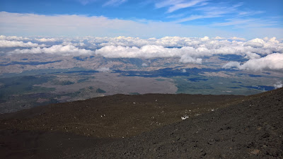
Clouds, lava and views from Mount Etna main crater.
Clouds, lava and views from Mount Etna main crater.Clouds, lava and views from Mount Etna main crater.

Main crater of Mount Etna, views we saw in the group tour.
Main crater of Mount Etna, views we saw in the group tour.Main crater of Mount Etna, views we saw in the group tour.

Left: On the way down, a view back to where we had come from. Right: Making our way down to the funivia top station.
Mount Etna - On the way down, a shot back to where we had come fromMount Etna - Making our way down to the funivia top station