Overview | Details | Flora | References | Trail Photos


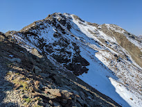
Left: View from the trail over Santa Caterina di Valfurva.
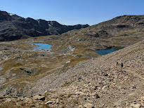
Right: On Trail 542 below Bormio 3000 with view toward Monte Confinale.
Overview
Length: 15 km (9 mi)
Duration: 4 hours
Elevation: Max elevation at Bormio 3000, 2,950 m (9,678 ft) to be precise. Min elevation at Bormio 2000 top station, 1,920 m (6,299 ft) to be precise. We tracked a total descent of 1,521 m (4,900 ft) – more than difference between min and max because of ups and downs on the trail.
Location: Italy, Valtellina, Bormio / Valdisotto / Valfurva
Details
Welcome to our eleventh hike of 2020. And yes, the title of this post is a mouthful! Considering that we – like most of the globe - spent a good part of the year in a lock down, we are calling eleven hikes this year a respectable achievement. By way of comparison, in the bodacious hike years of 2016 and 2017 we managed over 20 hikes a year. Here’s to a bodacious 2021!
So how did we end up in Bormio being that we are based in Bergamo? Well, we spent three days on the Valtellina Bike Path (Pista Ciclabile Valtellina) riding from Colico (on the north end of Lago Como) to Bormio, following the Adda river up the Valtellina valley. We tacked on one extra day in Bormio and did the hike described here. (To arrive in Colico we took the train from Bergamo – so this whole trip was in bike and train and bus.)
There are many hiking options around Bormio. Going up to the highest point served by cable cars is an easy way for non-walkers to take in the spectacular view. In the case of Bormio 3000 – which is at 2,950 m or 9,678 ft – the cable car is also the starting point for skiing, hiking, and MTB excursions. From the top station of Bormio 3000, from what we saw, hikers and bikers almost all head south along trail 541 toward I Bei Laghetti “The Beautiful (Small) Lakes” on the south side of Monte Vallecetta, away from Bormio. In winter, you would head north and ski down toward Bormio.
Our intention was to visit the alpine lakes and then return to Bormio 3000 to take the gondola back down, but once we got to the lakes, we decided to circumnavigate Monte Vallecetta counter-clockwise and walk back to Bormio 2000. It was a bit more work than we expected, and we were not equipped with our usual backpacks, water supply and gear. Instead we looked like we were out for walk around town and not alpine pastures at 8,000 ft.
Despite bad outfit choices, we finished the hike. The beautiful weather and views around each corner helped drive us forward until before we knew it, we were back at Bormio 2000. We justified our effort with beer and a calorific lunch back at Ristorante Girasole at the top station of Bormio 2000.
Here are some of the major orientation points of this hike:
- Bormio: Just south of historic center, catch the Bormio 2000 cable car.
- Bormio 2000: Get off Bormio 2000 and catch another cable car (one big gondola) up to Bormio 3000.
- Bormio 3000: This point also called Cima Bianca is at 2,950 m. (What’s 50 meters when you could round up for a catchy name?) From here, start walking approximately south toward the lakes on trail 541.
- I Bei Laghetti: Stop and enjoy the lakes.
- Bocca di Profa: Take 518 heading northeast descending the Valle di Sobretta.
- Valle di Sobretta: This valley is located between Monte Vallecetta (3,148 m) just above the Bormio 3000 station and Monte Sorbretta (3,296 m) to the south.
- Baita del Pastore: Once you reach the Baita del Pastore, pick up trail 542. Avoid taking the dirt road if you are on foot. Along the way you pass over a Val Calvarana.
- Sobrettina: The trail opens on to a pasture area here. Again, there is a dirt road option. We stayed high to remain on the trail 543.
- Rocca Est: The top of the farthest east ski run. From here, find your way back to Bormio 2000.
- Bormio 2000: Take the cable car back down. Don’t feel guilty after 15 km (9.3 mi) of walking, and not exactly all downhill.
Flora
At this point in the season, there wasn’t much flora to take pictures of. It's also the case that we don't have much experience with plants above 8,000 ft. From Bormio 3000 all the way down to Baita del Pastore, we saw mostly spent grasses. After Baita del Pastore, the altitude is about 2,400 m (7,874 ft) and we started to see plants in bloom/fruit that we could recognize, some of which are listed below.
[Asteraceae] Hieracium sp. - Hawkweed (Sparviere)![[Asteraceae] Hieracium sp. - Hawkweed (Sparviere) [Asteraceae] Hieracium sp. - Hawkweed (Sparviere)](https://blogger.googleusercontent.com/img/b/R29vZ2xl/AVvXsEgBPj0nfiD4NgTRbvCYhze9wb8GIoiywAoSV6AJW-Sf57l_KOVrC0B7G2VZToC3MFxBCKNrPY2t6PEkF9MpUbwFCXqIAOvyXh2y3KS-nUPUUFGJNvawV1tnQ0URurmj8HGqizikHqm8JqU/w205-h154/%255BAsteraceae%255D+Hieracium+sp..jpg)
[Campanulaceae] Campanula barbata - Bearded Bellflower (Campanula barbata)![[Campanulaceae] Campanula barbata - Bearded Bellflower (Campanula barbata) [Campanulaceae] Campanula barbata - Bearded Bellflower (Campanula barbata)](https://blogger.googleusercontent.com/img/b/R29vZ2xl/AVvXsEiI00w0mSYMkKn14YhE3EBy-i4Yf906thrzPY1EnZCWO-zVImn7m7oSEstBtnQSdeLuSYltDscwcEa1YNqZsChcyNy2bwJF_QMlbeeINNvJGmGxfpY-1wWfDpFqiikJ_GCWiMwg5BSePBc/w154-h205/%255BCampanulaceae%255D+Campanula+barbata.jpg)
[Ericaceae] Arctostaphylos uva-ursi - Kinnikinnick (Uva ursina)![[Ericaceae] Arctostaphylos uva-ursi - Kinnikinnick (Uva ursina) [Ericaceae] Arctostaphylos uva-ursi - Kinnikinnick (Uva ursina)](https://blogger.googleusercontent.com/img/b/R29vZ2xl/AVvXsEiVHw6G2hCWf9-FuuppfMXNJCDi8A2NZf6wYP2ckC9OQCWUQgLuiGd_oHBU1NNOusv4B38AjSjH7DWXP7qcbIgbddu8ZF_cp55P6f5sA3ZxVqVSAsx_g6EQLTbjLqwEYvPUrWnaZ9ca0ps/w154-h205/%255BEricaceae%255D++Arctostaphylos+uva-ursi.jpg)
[Ericaceae] Vaccinium mytrillus - Whortleberry, European Blueberry (Mirtillo nero)![[Ericaceae] Vaccinium mytrillus - Whortleberry, European Blueberry (Mirtillo nero) [Ericaceae] Vaccinium mytrillus - Whortleberry, European Blueberry (Mirtillo nero)](https://blogger.googleusercontent.com/img/b/R29vZ2xl/AVvXsEgFvu4uAtqzsVbqhuhNQ_P10lczRVe8TkdJhGUgu0Kj6FWEXwrzfdoVsXp8fo6R1c7lGJIlVPNKBoRhkiiarDBx81MgOQhq0olQuO8jvGvQxgEjVoOdHFgFXQaoFhqdbA7IZa-egenQbus/w205-h154/%255BEricaceae%255D+Vaccinium+mytrillus.jpg)
![[Ericaceae] Vaccinium mytrillus - Whortleberry, European Blueberry (Mirtillo nero) [Ericaceae] Vaccinium mytrillus - Whortleberry, European Blueberry (Mirtillo nero)](https://blogger.googleusercontent.com/img/b/R29vZ2xl/AVvXsEhbgHMgTeyIFIJubQ9o6uT-CMTsoHhGD_r0ERpBzSG6fz4wSz-LOZhnXQ1-I3ozNyZkS9i3jBhE_kZXYE-FqZsKw7Qz8eZsB8Bj7si_Y5Z1UHoWeX9Pwc7-_lboIaNxW9vVqlxQdMkhbfU/w205-h154/%255BEricaceae%255D+Vaccinium+mytrillus+-+red+leaves.jpg)
[Gentianaceae] Gentianella engadinensis - (Genzianella dell'Engadina)![[Gentianaceae] Gentianella engadinensis - (Genzianella dell'Engadina) [Gentianaceae] Gentianella engadinensis - (Genzianella dell'Engadina)](https://blogger.googleusercontent.com/img/b/R29vZ2xl/AVvXsEgSteiq4GEsxU_pLyoWrTvSzrVbgp4H6AuICAFRECeahmuczMgR4dYokIb97DBadZFap9PEGUEqOb-lbL7VBIG0QOIdnBbHoLn0g2OGYJZggOjBVuq2XcKvZ_VlesXslfUdO3h4gVOJR5Q/w205-h154/%255BGentianaceae%255D+Gentianella+engadinensis.jpg)
[Ranunculaceae] Aconitum napellus - Monk's-Hood, Wolfsbane (Aconito napello)![[Ranunculaceae] Aconitum napellus - Monk's-Hood, Wolfsbane (Aconito napello) [Ranunculaceae] Aconitum napellus - Monk's-Hood, Wolfsbane (Aconito napello)](https://blogger.googleusercontent.com/img/b/R29vZ2xl/AVvXsEhQVODHz8a2KQdIOuyPFHGv87NSCliaH80Am9YhVXTT2mNAyPculb8w_h1HnkseG6lrvQKBtwZkmiIdR5GgRy-2wvpfggTH1vQUrWna_-Xxfb1obUw0B0lE-nvPApisF_8AMJ3PIUEMv9A/w205-h154/%255BRanunculaceae%255D+Aconitum+napellus.jpg)
References
Trail Photos


No comments:
Post a Comment
All comments are moderated. If your comment doesn't appear right away, it was likely accepted. Check back in a day if you asked a question.