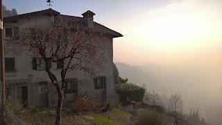
Left: Hike overview. Start and end was in Bergamo. Right: View of San Vigilio from Via Colle dei Roccoli.


Hike Notes
Length: 14.3 miles (23 km).Duration: About 6.5 hours, with a little futzing time at Santuario del Sembrano our turn around point.
Elevation: Total elevation gain 2,832 feet (863 m), max elevation 1,563 feet (476 m), starting elevation 844 feet (257).
Location: Parco di Colli di Bergamo, Bergamo, Province of Bergamo
Overview
The first hike of the year is in the city we are on the verge of adopting as a home and it was a great introduction to the hills and forested area just north of the Bergamo. This area is part of what is called the Parco di Colli di Bergamo. On this hike, we walked out of the Bergamo historic center (we are staying on Via Tasso) up the Città Alta and kept on going northwest until we reached the Santuario di Sembreno. These series of hills are part of the Bergamasque Prealps with Bergamo at the southeastern tip and Paladina at the northwestern tip.
There are many ways you could walk these hills. With a good paper map (for example, we used the map Carta dei sentieri del Parco dei Colli di Bergamo and the book Escursionismo nelle valli bergamasche) and your favorite map application, you are set to explore and make your own path. Once you get used to the red and white signs, you can find your way around with confidence. The signs show time (h) to destination, and on occasion distance (km).
On this first day of 2016, we walked under a sunny winter sky which forced us to shed our jackets a few times when in the sun and climbing, especially on the west side of the hills. We saw bikers, joggers, and walkers of all types taking advantage of the sun and the holiday.
We started our walk from from Caffè Papavero (Via Pignolo, 96) -- a perfect start to any day – and after coffee headed up to Città Alta. From the Porto S. Agostino, we went northwest to Santuario del Sembrano and then reversed our path with some differences on the way back. On our return trip we took the Sentiero dei Vasi (912) and then came straight back through the heart of Città Alta, with slighty muddy boots hoping to pick up pane noce e uvetta and pane cioccolato at Il Fornaio (Via Bartolomeo Colleoni, 1).
It's one of those hikes (like the Canto Alto hike we did a few days earlier) that combines city, maintained countryside "agroforestali", bits of wild and neglected spaces, and always something interesting to stop and puzzle over. Along the way you are never far from the sound of church bells, sometimes in chorus as they ring from different towns. Walking the spine of these hills feels like you are eavesdropping on the towns below.
Left: At the beginning of the hike - Fontana del delfino; Right: House and persimmon tree on Via Colle dei Roccoli. The weird look to the atmosphere is due to high particulate matter, a problem in the Milan and Bergamo area this year due to unusually warm weather and lack of rain.


Left: Southern part of sentierio 711. Center: Example signage for sentiero 711. Right: Entrance to Santuario di Sembreno.


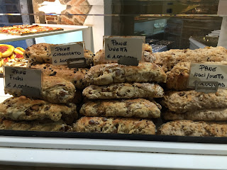
Left: The prize at at the end of the hike at Il Fornaio in the Città Alta, pane noci e uvetta and pane cioccolato. Right: A “roccoli,” which is a bird snare that was common hundreds of years ago. Some roccoli are still in use for catching or studying birds. For more information, see Italian Historical Rural Landscapes: Cultural Values for the Environment and Rural Development. The Colli di Bergamo includes the streets Colle dei Roccoli and the Colle di Roccolone (big roccoli?).
Signage along the Sentiero dei Vasi (912) trail, a walk on an ancient acqueduct.This trail has interesting and signs with interesting tidbits of information spread out along the trail. In one part, gold flashy leave shapes dangled from the bare trees living up the late winter afternoon. The photo here shows recipes based on the local flora: Piantaggine lanceolata (Plantain), Fragaria vesca (Woodland strawberry), Symphytum tuberosum (Tuberous comfrey), and Rumex acetosa (Sorrel).


No comments:
Post a Comment
All comments are moderated. If your comment doesn't appear right away, it was likely accepted. Check back in a day if you asked a question.