Sunday, December 9, 2012

Þingvellir (Thingvellir) - The Thing Fields


Left: View from Almannagjá Looking North Toward Armansfell. Right: View South over Þingvellir
View from Almannagjá Looking North Toward ArmansfellView South over Þingvellir

I can’t tell you how long the name of this place has held me tongue-tied. Before going to Iceland and visiting the national park and now that we have returned, I’m still unsure about pronouncing it. I still slur it in conversation hoping no one will notice. Well here’s my last attempt to understand it.

  • In Icelandic it is written: Þingvellir.
  • It is often anglicized as Thingvellir or as Thing Fields. The former is the spelling the park uses itself (http://www.thingvellir.is/).
  • You can use Wikipedia to help decipher the correct pronunciation as : θiŋkˌvɛtlɪr where
    • θ think
    • i pea
    • ŋ sing
    • k sky
    • v very
    • ɛ pet
    • t sty
    • ɪ pick
    • r (voiceless, like hr)

We first learned about the THING Project on a sign in a café. According to the plaque we saw, “Things are the assembly sites spread across North West Europe as a result of the Viking diaspora and Norse settlements.” In fact the national parliament of Iceland is called the Alþingi (anglicized as Althing or Althingi) literally means “all-thing”. The parliament was established at Þingvellir in 930 and remained there until 1789. The Þingvellir National Park was founded in 1930.

We spent about four hours wandering around the park, most of the time was walking the Almannagjá - a small canyon really - that marks the eastern boundary of the North American plate. Its equivalent canyon across the graben (the wide plain or fault trough that Þingvellir is on the west edge of) marks the western boundary of the Eurasian plate and is called Hrafnagjá. For more on the geology of this area, see Geology and tectonics of Þingvellir.

There are many ways into the park. The most typical entry is via Hakið Visitor Center, with an interpretive center and access to the Almannagjá. We came into the park from the north in the plain/graben from route 361. The only food option (besides bringing your own) is at Þjónustumiðstöðin Information Centre, at the junction of 36 and 361. It has limited hours off season.

Thingvellir Brochure
Thingvellir Brochure Thingvellir Brochure

Thingvellir – Near Law Rock Looking SouthThingvellir – Near Law Rock Looking South

Looking South Over the Rift Almannagjá and Its Walking PathLooking South Over the Rift Almannagjá and Its Walking Path

Friday, December 7, 2012

Flora Resources for Iceland

Flowering Plants and Ferns of Iceland by Hörður Kristinsson (back and front)
Flowering Plants and Ferns of Iceland by Hörður Kristinsson - backFlowering Plants and Ferns of Iceland by Hörður Kristinsson - front

We picked up both of these two flora resources at the Gullfoss Visitor center (after a delicious bowl of lamb soup). One is a book and one is a map.

The first resource is the book Flowering Plants and Ferns of Iceland by Hörður Kristinsson. The book uses a color key system where plants are divided into eight color groups. You choose a group by noting the color of the flower of the plant and then leaf (!) through the group to find an exact match. Several groups (white, yellow and other colors) are further subdivided according the size and shape of their flowers. The author acknowledges that the key is designed to have the most benefit to non-plant experts. The only problem is that in winter it was hard to determine the flower color!

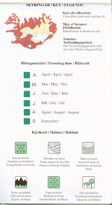
The second resource is a Botanical Map is a map that shows 78 flowering plants, their distribution, and names in three languages. The map folds out like a road map, but it’s not what you expect as one big map of the country. Rather it contains a 6 by 8 grid on one side and a 6 x 5 grid on the other where each square in the grid contains information about one plant including a color drawing, the binomial name, the common name in Icelandic, English, and German, the flowering month, habitat, and distribution of the plant.

Unfortunately, we did not get a chance to really exercise either of these resources given that all plants were out of bloom and we had such a limited time to spend hunting for plants. (When there is so little light at this time of the year, we were more interested in getting from site to site and not spending much time hunting for plants.) Given these limitations, it was surprising how many plants we did see and were able to identify.

Update: We went back in 2015 and were able to "exercise" these resources. Please see Selected Plants from Our Iceland Trip.

Both of these plant resources can be purchased on Shop Icelandic last time we checked so you don’t even have to go Iceland to get them!

Some other resources we used to help us prepare this post include:
Speaking of plants, the glow of a greenhouse (usually growing cucumbers or tomatoes were told) is a site we saw a few times. Something like 80% of Iceland’s energy is geothermal and it makes sense to heat and light the greenhouses to keep the vegetables happy in winter.
 
Iceland Botanical Map
Iceland Botanical Map Iceland Botanical Map
  
Iceland Botanical Map Sample Map Section for Dwarf Birch (Betula nana).
Iceland Botanical Map Sample Map Section for Dwarf Birch (Betula nana)Iceland Botanical Map Sample Map Section for Dwarf Birch (Betula nana)

Greenhouse in Reykholt, Iceland Growing Cucumbers


Woolly Fringe Moss (Racomitrium lanuginosum) with Crowberry (Empetrum nigrum) in Kerið Volcano Crater


Alpine Lady’s Mantle (Alchemilla alpina) – likely - in Kerið Volcano Crater
 

Wild Thyme (Thymus praecox subsp. articus) in Kerið Volcano CraterWild Thyme (Thymus praecox subsp. articus) in Kerið Volcano Crater

Layers in Þingvellir (Thingvellir Park): sod on a wall, Tea-Leaved Willow (Salix pylicifolia) in orange browns, and Woolly Fringe Moss in the background.


Thursday, December 6, 2012

A Few Reykjavík Murals


We simply didn’t have enough time to capture that much street art around Reykjavik being there only two days. Here are a few images we captured around the main shopping street Laugavegur (northwest end of Reykjavik). Most of the these photos were taken in a space between Hverfisgata and Laugavegur between Smiðjustígur and Klapparstígur. From what we can tell, this is just scratching the surface of all the hidden murals and artwork. An article from the Grapevine gives some context to the murals: these are waiting areas “that have been sidelined in the planning process, and handed over to artists and cultural players to create dynamic temporary works and ignite debate about the future of the cityscape. It is the latest of the many ‘meanwhile projects’ that can be seen across town, commissioned by the City of Reykjavík to stimulate otherwise neglected spaces.”


Wednesday, December 5, 2012

Too Many Maps - Iceland Case Study

Do you have this problem? You are touring a new area (country, city, etc.) and you come home with a pile of paperwork. You can’t seem to get rid of it before going home. It might contain valuable information, right? Or so you tell yourself and so you end up with a pile of slips of paper, museum guides, business cards, and maps, especially maps. We were in Iceland for 5 days recently and it seemed like every time we asked someone a question, that person whipped out a map and made an “X” on it and handed it to us before I could say, “but we already have a map”. And so timidness and being slow-to-the-draw resulted in a pile of maps - all of various usefulness. We have a big plastic bin at home that contains maps of places we’ve been. We hardly open that bin when embarking on a trip to a location from which we’ve already collected maps. Sigh.

Each map we collected in Iceland has some particular bent behind it. There are dining maps, auto-rental maps, bus route maps, tour company promotional maps, regional promotional maps, and many more. We purchased the International Travel Maps map of Iceland before we left (www.itmb.com) but didn’t use it much.

For Reykjavík, we used the Big Map the most (www.bigmap.is). In the Golden Circle we used the excellent Uppsveitir Árnessýslu map (www.sveitir.is) and see below. 

Besides the physical maps, we had iPhone and Windows Phone mapping applications and a Garmin Nuvi 270. What we found is that a physical map was still the best used in conjunction with a phone mapping application for a sanity check to make sure you taking the right turns.

Big Map 2012-2013, Left: Inside, Right: Cover


Bus Route Map, Left: Side 1, Right: Side 2 Sponsored by the Saga Museum?


Various Other Iceland Maps

Iceland Excursions Map, Left: inside, Right: Cover

The Most Useful Map for the Golden Circle Area – Upper Árnessýslu Area. This map has all the sites you’ll typically see and a brief description of them.  
What’s On Map of Reykjavik, Left: Inside, Right: Cover


Tuesday, November 13, 2012

Binomen Art - Lantana


Lantana Spelled Out with Berries (left) and Floret and Berries (right)
LantanaLantana
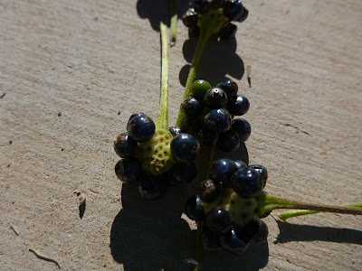
We made me stop were the berries. I never saw Lantana with berries, green (unripe) and blue-black (ripe) berries. Time for a binomen-art project. I believe this is Lantana camara or Lantana montevidensis a plant in the Verbenaceae (Verbena) family. I guess Lantana is quite evasive, however, for this dusty front yard in Henderson Nevada it seemed so innocent and brought some much needed color. Looks can be deceiving.

I plucked a few of the berries (drupes) and arranged to them spell the generic name, Lantana. The generic name origin according to Quattrocchi is: related to the ancient name for viburnum and in spoken Latin it is called lentaginem, from lentus “pliant” (“lenta viburnum”). (I swear I heard someone say lentaginem on the bus the other day.)

The common name of L. camara is Spanish Flag or West Indian Lantana. Because L. camara emits a pungent odor (when you crush the leaves for example), a few local common names reference the smell. My favorite is the Filipino (Tagalog) utot-utot ‘fart’ [flower].

Lantana Spelled Out with Berries (left) and Floret and Berries (right)
LantanaLantana

Lantana Berries
Lantana Lantana