Tuesday, August 29, 2017

Hike: Passo Porcile and Rifugio Dordona from Foppolo


The route from Foppolo to Rifugio Dordona and back.View of Laghi di Porcile from Passo Porcile.
Left: The route from Foppolo to Rifugio Dordona and back. Right: View of Laghi di Porcile from Passo Porcile.

Overview


Length: 12 km (7.5 mi)
Duration: ~ 5.5 hours walking time, 4 hours before lunch, 1.5 hours after lunch
Elevation: 1625 m (5,330 ft) @ Foppolo, 2316 m (7,598 ft) @ Passo dei Lupi. Total elevation gain of 1310m (4,298 ft).
Location: Italy, Lombardy, Alta Valle Brembana

The Hike


This was day two of two days of hiking in Foppolo. The first day we hiked to Lago Moro above Foppolo. See that post for details on how to get to Foppolo by bus. One of the reasons why we planned two days here – besides getting in more hiking – is that the bus schedule between Bergamo and Foppolo didn't allow enough time in one day to get in a good hike.

After a day of hiking about 11 km, we stayed the night in Foppolo at Hotel Adler. It was nice because we seemed to be the only guests and had it to ourselves. We had a good dinner there too.

Day two’s hike was built around a lunch stop at Rifugio Dordona. We took Sentiero 201 toward Passo Tartano and then switched to Sentiero 201a toward Passo di Dordona. Just before reaching Passo di Dordona, you take a slight detour to reach Rifugio Dordona. From Passo Dordona it’s Sentiero 202 back to Foppolo.

Flora and Fungi


Flora: [Asteraceae] Hieracium intybaceum – Whitish Hawkweed (Italiao: Sparviere cicoriaceo)

Flora: [Campanulaceae] Phyteuma sp.

Flora: [Ranunculaceae] Aconitum napellus – Monk’s-Hood (Italian: Aconito napello)

Fungi: [Boletaceae] Boletus sp. Given that it was found under a pine tree, we are guessing it is Boletus pinophilus. It was found by local man we met on the trail.


Aconitum napellus – Monk’s-Hood (Italian: Aconito napello).[Asteraceae] Hieracium intybaceum – Whitish Hawkweed (Italiao: Sparviere cicoriaceo).[Asteraceae] Hieracium intybaceum – Whitish Hawkweed (Italiao: Sparviere cicoriaceo).
Left: Aconitum napellus – Monk’s-Hood (Italian: Aconito napello). Center and right: [Asteraceae] Hieracium intybaceum – Whitish Hawkweed (Italiao: Sparviere cicoriaceo).

[Campanulaceae] Phyteuma sp. Boletus sp. Given that it was found under a pine tree, perhaps Boletus pinophilus. A rock-piece of iron ore under Monte Capelle.Trail signs at Passo (or Bocchetta) dei Lupi (2316 m).
Left: [Campanulaceae] Phyteuma sp. Center left: Boletus sp. Given that it was found under a pine tree, perhaps Boletus pinophilus. Center right: A rock-piece of iron ore under Monte Capelle. Right: Trail signs at Passo (or Bocchetta) dei Lupi (2316 m).

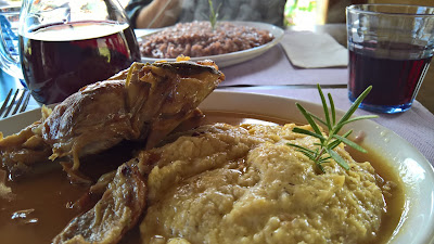
Lunch at Rifugio Dordona - polenta with stinco da maile and risotto with sausage and red wine. Grappa Nostrana al Larice - "Our grappa made from larch" pine cones at Rifugio Dordona.Tunnel in the WWI trenches at Passo di Dordona.WWI trench at Passo di Dordona.Mules watching us on Sentiero 201 up to Passo di Porcile.
Left: Lunch at Rifugio Dordona - polenta with stinco da maile and risotto with sausage and red wine. Center left: Grappa Nostrana al Larice - "Our grappa made from larch" pine cones at Rifugio Dordona. Very good! Center: Tunnel in the WWI trenches at Passo di Dordona. Center right: WWI trench at Passo di Dordona. Right: Mules watching us on Sentiero 201 up to Passo di Porcile.

Sentiero 201 above Foppolo and mules.Coming down from Passo dei Lupi toward Rifugio Dordona.Sentiero 201 just above Foppolo, close to where porcino was found.
Left: Sentiero 201 above Foppolo and mules. Center: Coming down from Passo dei Lupi toward Rifugio Dordona. Right: Sentiero 201 just above Foppolo, close to where porcino was found.

The finish of the hike on Sentiero 202 heading down toward Foppolo.

Monday, August 28, 2017

A Hike to Lago Moro above Foppolo


Route from Foppolo to Lago Moro. View from above Lago Moro looking north toward Monte Disgrazia.
Left: Route from Foppolo to Lago Moro. Right: View from above Lago Moro looking north toward Monte Disgrazia.

Overview


Length: 11 km (6.8 mi)
Duration: ~ 5.25 hours walking time, 1.25 hours before lunch, 4 hours after lunch
Elevation: 1625 m (5,330 ft) @ Foppolo, 2500 m (8,200 ft) @ above Lago Moro. Total elevation gain of 1026 m (3360 ft).
Location: Italy, Lombardy, Alta Valle Brembana

The Town


Foppolo is a small village located 60 miles north of Bergamo in the upper Val Brembana. In winter, it is one of the most important ski centers in the Bergamo Alps. You can reach Foppolo by bus from Bergamo in about two hours, which is how we got there. From Bergamo, take Linea B (for Brembana) to Piazza Brembana and then transfer to the bus heading for Branzi-Carona-Foppolo.

The location around Foppolo is spectacular: the mountains are beautiful and the views, when you get up high, are some of the best we’ve seen. However, it is primarily a ski-town, and ski-towns can (and in this case did) have a number of things against them from a hiker’s point of view.

First, there’s the architecture. Foppolo’s architecture – dedicated to skiing – is a combination of atrocious and bizarre, with hotels resembling part chalet, part bunker, and part high-rise prison. We stayed in one of these places one night and the service and accommodations were great, just that their outsides are brutal looking. Secondly, hiking on or near ski slopes in the summer is always a delusion for us. The slopes look like war zones in the summer. The chaotic, bedraggled looking slopes was admittedly softened by the pasturing cows and the sounds of their bells. In the summer, the cows rule the slopes!

To make matters worse, the slopes above Foppolo are in the midst of a massive-but-halted construction of a new gondola. Huge pits were dug for support beams and then stopped. The future of the gondola at time of writing is uncertain due to funding.


Cows on the ski slopes above Foppolo. Above the ski slopes near Corno Stella, a view toward Monte Disgrazia and Valtellina.View from Lago Moro south toward Branzi.
Left: Cows on the ski slopes above Foppolo. Center: Above the ski slopes near Corno Stella, a view toward Monte Disgrazia and Valtellina. Right: View from Lago Moro south toward Branzi.

Another knock on ski towns: they have layouts that make no sense unless you are on skis. The entrance to the hotel we were staying at took us 10 minutes to find. The main entrance was turned towards the slopes, but we were trying to enter from the road. After walking back and forth we saw a little sign that we followed up four flights of stairs to the other side of the hotel. Viola, entrance!

The Hike

When we stepped off the bus in Piazzale degli Alberghi, the upper part of Foppolo, it was like stepping into a ghost town. For half a second, I thought about getting back on the bus for Bergamo. The town was much livelier the previous week with families and vacationers taking their last bit of vacation before heading back home to get ready for the start of school and work. Today, the town and its hotels and restaurants were taking a respite and counting the days before snow arrived to bring in the winter crowd.

We found a seat on the edge of the big asphalt piazza and got changed for the hike. When we went to find the start of the trail, we became confused. We asked a few people we found sitting outside at a bar and they help us get oriented. One of the guys asked us where we were from, and then told us he had been to Seattle and gushed about beautiful it was. Ah Seattle.

This was day one of two day stay in Foppolo. For this first day, since we arrived in Foppolo around 1:00 pm, we  didn’t plan on anything big or interesting. Yet, this walk turned out to quite scenic. Fresh off the bus, changed and oriented in the right direction by some helpful locals, we headed up to Rifugio Montebello (Terrazzo Salomon) for a quick lunch. It took about one hour and 15 minutes to get to the rifugio on foot, through the war zone called a summer ski slope. We followed a combination of Sentiero 204 and Sentiero 205 and a bit of just going straight up the slope. This was the least interesting part of the hike.

After lunch at Montebello, we headed to Lago Moro (dark lake) continuing on Sentiero 204. This is where the scenery became much nicer and the goal of the hike. At Lago Moro, we took a side trip partway up to the famous Corno Stella (Orobie). Then we came back to Lago Moro and picked up Sentiero 204a back to Montebello and down to Foppolo. Sentiero 204a takes you up to Passo di Valcervia (2318 m) for beautiful views north towards Valtellina and Switzerland.

Flora and Fauna and Fungi


Flora-wise, we didn’t really see that much, though it was the first time we’ve seen Hieracium intybaceum – Whitish Hawkweed (Sparviere cicoriaceo) and Leucanthemopsis alpina – Alpine Moon Daisy (Margherita alpina), both part of the daisy family. Fungus-wise, we saw a whole lot of what we think is the fungus Exobasidium rhododendri on Alpenrose (Rododendron ferrugineum). And finally, fauna-wise, we saw about ten chamoix around Lago Moro. They seemed curious about us. If we stopped and stared at them, they stared right back. It was usually us who blinked first.

Fauna: [Bovidae] Rupicapra rupicapra – Chamois (Camoscio alpino)
Flora: [Asteraceae] Carlina sp. likely C.acaulis – Stemless Carline Thistle (Carlina bianca)
Flora: [Asteraceae] Hieracium intybaceum – Whitish Hawkweed (Sparviere cicoriaceo)
Flora: [Asteraceae] Leucanthemopsis alpina – Alpine Moon Daisy (Margherita alpina)
Flora: [Campanulaceae] Campanula barbarta – Bearded Bellflower (Campanula barbata)
Flora: [Gentianaceae] Gentianella germanica – Chiltern Gentian (Genzianella tedesca)
Flora: [Polyganaceae] Rumex alpinus – Munk’s Rhubarb, Alpine Dock (Romice acetosella)
Fungi: [Exobasidiaceae] Exobasidium rhododendri on Rhododendron ferrugineum


Carlina with butterflies. Campanula barbarta – Bearded Bellflower (Campanula barbata).Exobasidium rhododendri on Rhododendron ferrugineum.Gentianella germanica – Chiltern Gentian (Genzianella tedesca).
Left: Carlina with butterflies. Center left: Campanula barbarta – Bearded Bellflower (Campanula barbata). Center right: Exobasidium rhododendri on Rhododendron ferrugineum. Right: Gentianella germanica – Chiltern Gentian (Genzianella tedesca). I was surprised to see a flowers with four and five petals on the same plant.  Open question: a plant with all flowers of four petals would then be G. campestris.

Hieracium intybaceum – Whitish Hawkweed (Sparviere cicoriaceo). Hieracium intybaceum – Whitish Hawkweed (Sparviere cicoriaceo). Leucanthemopsis alpina – Alpine Moon Daisy (Margherita alpina).Rumex alpinus – Munk’s Rhubarb, Alpine Dock (Romice acetosella).
Left and center left:  Hieracium intybaceum – Whitish Hawkweed (Sparviere cicoriaceo). Center right: Leucanthemopsis alpina – Alpine Moon Daisy (Margherita alpina). Right: Rumex alpinus – Munk’s Rhubarb, Alpine Dock (Romice acetosella) on Sentiero 203.

A chamois scurries away near Lago Moro.A chamois making its way down to Lago Moro from Corno Stella.Mother and baby chamois going down to Lago Moro.
Photos of chamoix above Foppolo. Left: A chamois scurries away near Lago Moro. Center: A chamois making its way down to Lago Moro from Corno Stella. Right: Mother and baby chamois going down to Lago Moro.

Above Lago MoroWalking from Rifugio Montebello to Lago Moro.  Heading back to Rifugio Montebello on Sentiero 203.
Walking around Lago Moro. Left: Above Lago Moro. Center: Walking from Rifugio Montebello to Lago Moro. Right: Heading back to Rifugio Montebello on Sentiero 203.

Lunch at Rifugio Montebello, polenta and slow-cooked beef, pizzoccheri (pasta of buckwheat), and chocolate cake.Lunch at Rifugio Montebello, polenta and slow-cooked beef, pizzoccheri (pasta of buckwheat), and chocolate cake.Signs at bottom of ski slope pointing the way up to Rifugio Montebello and Lago Moro.Walking on part of Corno Stella above Lago Moro.
Left and center left: Lunch at Rifugio Montebello, polenta and slow-cooked beef, pizzoccheri (pasta of buckwheat), and chocolate cake. Center right: Signs at bottom of ski slope pointing the way up to Rifugio Montebello and Lago Moro. Right: Walking on part of Corno Stella above Lago Moro.

Starting the climb up Corno Stella.

Tuesday, August 22, 2017

A Hike from Passo Presolana to Rifugio Rino Olmo to Castione della Presolana


The annotated hike route around Presolana.A view from trail 327 east toward Malga della Presolana.
Left: The annotated hike route around Presolana. Right: A view from trail 327 east toward Malga della Presolana.


Overview


Length: 14 km (8.7 mi)
Duration: 4.8 hours, 3 hours before lunch, 1.8 hours after lunch
Elevation: Max elevation 2230 m (7,316 ft) Grotta dei Pagani, minimum elevation 874 m (2,867 ft) Castione della Presolana, cumulative elevation gain 1230 m (4,035 ft), lost 1651 m (5,417 ft)
Location: Italy, Lombardy, Bergamo Province, Alta Val Seriana

Details


In a nutshell, the hike was this:

Bergamo Bus Station -> Cantoniera della Presolana (Passo della Presolana) -> Sentiero 315 -> Grotta dei Pagani -> Sentiero 320 -> Rifugio Rino Olmo -> Sentiero 327 -> Sentiero 317 -> Rusio -> Castione della Presolana -> Bergamo Bus Station.

We decided to do this hike counterclockwise and end up in Castione della Presolana rather than starting there because the bus connections back to Bergamo were better from Castione. To get to Passo Presolana take the Linea S route to Clusone and then change to the Linea S70a, which goes over the pass (see BergamoTrasporti.it). Let the bus driver know you want Passo Presolana when you get on the bus in Bergamo, because as in our case, the connection was close and he honked at the other driver to wait for us.

We did the start of this hike before (see Hiking Below Pizzo della Presolana) but didn’t make it far. This time, we were set on going to Rifugio Olmo for lunch. It’s all about the food.
The trails were fine at this time of the year and signed well. We wanted to check out Grotta dei Pagani, but you can avoid that scramble up the scree if you are not interested. The grotta is a small cave and nothing that special. Perhaps we are a tad sour on the cave because one of us dropped a phone and that was the end of life for it. It put a little bit of a damper on the rest of the hike.

Presolana is the located in the Bergamasque Prealps in the province of Bergamo. It has a similar limestone composition as the Dolomites located in northeastern Italy. The Italian Wiki page for Presolana gives a number of possible etymologies for its name. The one I found most plausible (because legends and spirits don’t sit well with me as explanations) is that Presolana is derived from the dialect praizzöla (in Italian praticciolo) due to the small prati (meadows) on Presolana’s slopes, several which this hike takes you through or are visible from the trail. Prati plus the diminutive icciolo basically meaning little meadow. It’s a small step sound-wise from praizzöla to Presolana.

At Passo della Presolana, coffee and cake before starting the hike. Tagliatelle fatta in casa with mushroom and cream sauce at Rifugio Olmo.Slow cooked beef, polenta and cheese.Dessert at Rifugio Olmo.
Left: At Passo della Presolana, coffee and cake before starting the hike. Center left: Tagliatelle fatta in casa with mushroom and cream sauce at Rifugio Olmo. Center right: Slow cooked beef, polenta and cheese. Right: Dessert at Rifugio Olmo.

While we reached 2259 m (7411 ft) at Grotta dei Pagani, the peaks of Presolana were still higher by a couple hundred meters. We didn’t go up.

The advantage of this hike routing is beautiful scenery and you don’t have to double back and repeat a trail. The disadvantage is that the part from Malga del Campo (about 30 minutes after Rifugio Olmo on the way to Rusio) is kind of boring. It’s mostly on a road that is roughly paved with large stones and cement.


Flora


For help identifying plant on hikes around Bergamo, see the post Resources for Identifying Plants around Bergamo.

Key: [Family] Genus species – Common name in English (Common name in Italian)

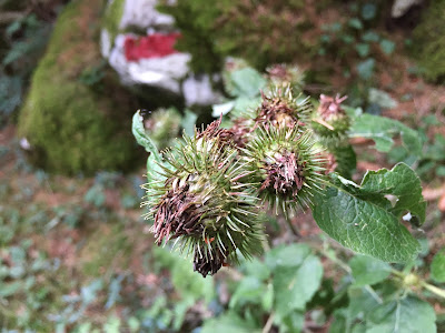
[Asteraceae] Arctium nemorosum – Burdock (Bardana selvatica)
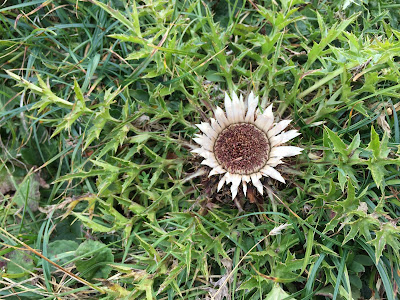
[Asteraceae] Carlina acaulis – Stemless Carline Thistle (Carlina bianca) – could be subsp. acaulis
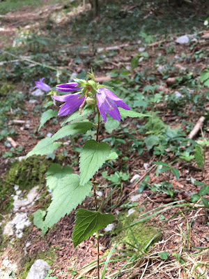
[Campanulaceae] Campanula trachelium - Nettle-Leaved Bellflower (Campanula selvatica)
[Gentianaceae] Gentiana asclepiadea - Willow Gentian (Genziana di Esculapio)
[Gentianaceae] Gentianella germanica – Chiltern Gentian (Genzianella tedesca)
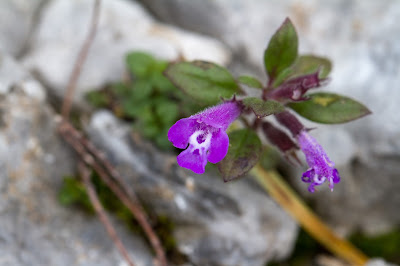
[Lamiaceae] Clinopodium alpinum – Alpine Calamint (Acino alpino)
[Lamiaceae] Salvia glutinosa – Sticky Sage, Yellow Sage (Salvia vischiosa)
[Lamiaceae] Stachys pradica – (Betonica densiflora, Betonica del monte Prada)
[Papaveraceae] Corydalis lutea – Yellow Corydalis (Colombina gialla)
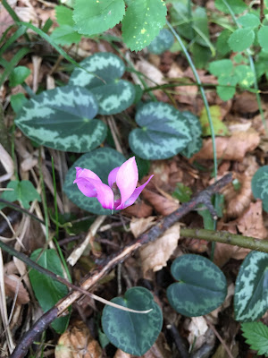
[Primulaceae] Cyclamen purpurascens - Cyclamen (Ciclamino delle Alpi)
[Rosaceae] Dryas octopetala – White Dryas (Camedrio alpino)
[Saxifragaceae] Saxifraga paniculata – Encrusted or Livelong Saxifrage (Sassifraga pannocchiuta)
[Scrophulariaceae] Rhinanthus alectorolophus – Greater Yellow Rattle (La cresta di gallo comune)
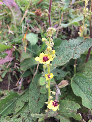
[Scrophulariaceae] Verbascum nigrum – Dark Mullein (Verbasco nero) - could be V. alpinum


Arctium nemorosum – Burdock (Bardana selvatica).Carlina acaulis – Stemless Carline Thistle (Carlina bianca) – could be subsp. acaulis. Cirsium - Thistle.
Left: Arctium nemorosum – Burdock (Bardana selvatica). Center: Carlina acaulis – Stemless Carline Thistle (Carlina bianca) – could be subsp. acaulis. Right: Cirsium - Thistle.

Clinopodium alpinum – Alpine Calamint (Acino alpino).Clinopodium alpinum – Alpine Calamint (Acino alpino). Dryas octopetala – White Dryas (Camedrio alpino). Salvia glutinosa – Sticky Sage, Yellow Sage (Salvia vischiosa).Stachys pradica – (Betonica densiflora, Betonica del monte Prada).
Left and center left: Clinopodium alpinum – Alpine Calamint (Acino alpino). Center: Dryas octopetala – White Dryas (Camedrio alpino). Center: Salvia glutinosa – Sticky Sage, Yellow Sage (Salvia vischiosa). Right: Stachys pradica – (Betonica densiflora, Betonica del monte Prada).

Saxifraga paniculata – Encrusted Saxifrage, Livelong Saxifrage (Sassifraga pannocchiuta).Gentiana asclepiadea - Willow Gentian (Genziana di Esculapio).Verbascum nigrum – Dark Mullein (Verbasco nero) - could be V. alpinum.Campanula trachelium - Nettle-Leaved Bellflower (Campanula selvatica).Cyclamen purpurascens - Cyclamen (Ciclamino delle Alpi) - bloom time August and September.
Left: Saxifraga paniculata – Encrusted Saxifrage, Livelong Saxifrage (Sassifraga pannocchiuta) lime-encrusted leaves. Center left: Gentiana asclepiadea - Willow Gentian (Genziana di Esculapio). Center: Verbascum nigrum – Dark Mullein (Verbasco nero) - could be V. alpinum. Center right: Campanula trachelium - Nettle-Leaved Bellflower (Campanula selvatica).  Right: Cyclamen purpurascens - Cyclamen (Ciclamino delle Alpi) - bloom time August and September.

Corydalis lutea – Yellow Corydalis (Colombina gialla).Gentianella germanica – Chiltern Gentian (Genzianella tedesca).Rhinanthus alectorolophus – Greater Yellow Rattle (La cresta di gallo commune).
Left: Corydalis lutea – Yellow Corydalis (Colombina gialla). Center: Gentianella germanica – Chiltern Gentian (Genzianella tedesca). Right: Rhinanthus alectorolophus – Greater Yellow Rattle (La cresta di gallo commune).

Road to Rusio, Trail 317.Coming down from Grotta dei Pagani and heading toward Rifugio Olmo. Just below Baita Cassinelli.
Left: Road to Rusio, Trail 317. Center: Coming down from Grotta dei Pagani and heading toward Rifugio Olmo. Right: Just below Baita Cassinelli.

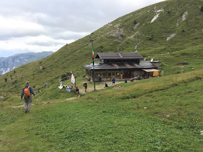
Upper and lower paths leading to Passo di PozzeraView from Passo di Pozzera toward Malga della Presolana.Approaching Rifugio Rino Olmo.
Left: Upper and lower paths leading to Passo di Pozzera. Center: View from Passo di Pozzera toward Malga della Presolana. Right: Approaching Rifugio Rino Olmo.

View toward bivuoac Citta di Clusone on trail 315View toward bivuoac Citta di Clusone on trail 315.Map showing the Presolana zone with ridge lines and trails.
Left and center:Views toward bivuoac Citta di Clusone on trail 315. Right: Map showing the Presolana zone with ridge lines and trails.