

Top row left: View from trail to Pointe du Raz back toward Plage de la Baie des Trépassés (Plogoff, France).
Top row center: Tracks from Pointe du Van to Pointe du Raz and back.
Top row right: From Pointe du Van looking east into the Bay of Douarnenez.
Bottom row left: Walking south with Ponte du Raz in the distance.
Bottom row center: Ferns, water, sand - Plage de la Baie des Trépassés
Bottom row right: Roof of Chapelle catholique Saint-They de la pointe du Van.
Length: 15.5 km
Duration: 6 hours, including stop for lunch
Elevation gain: 169 m
Location: France, Brittany, Finistère, Pointe du Raz
One of the days out of Douarnenez on our 8 days in France was to hike between these two points in Western Brittany, France. We were advised to park at Pointe du Van and walk to Pointe dur Raz and back. Why? Most people arrive at the Pointe du Raz parking point (where there are food and shops) and therefore Pointe du Raz is busier. And that was the case.
We started out around 10 am at the Pointe du Van parking area with just a few other vehicles. When we returned 6 hours later to our car, the place was jam-packed. Besides the parking areas (at both points) and the actual Pointe du Raz viewpoint west toward the Île de Sein and the Chaussée de Sein, we didn’t see that many people on the trails themselves. So, walking was easy.
As you can tell by the small elevation gain, this is mostly a flat hike. That doesn’t mean it’s easy—especially on a hot day. There are few to no trees to be found. The shade of a church or monument is your only respite from the sun. Water sources are facilities at the parking areas and the bars/restaurants along Plage de la Baie des Trépassés, which is midpoint in the hike.
Lunch, and you know there must be lunch with Travelmarx, was at the very fun Monsieur Papier, a bookstore café.
After lunch, we headed back to Pointe du Van passing by the historical site called Blockhaus de Men Tan near Lescoff in Plogoff, Brittany. The site was part of the German radar station QU13 during World War II. Men Tan, meaning ‘stone of fire’ in Breton, was built by the German military in 1944 as part of the Atlantic Wall. The site hosted a Mammut radar, one of the largest and most powerful of its kind at the time. The radar was mounted on a massive L485 (standardized) bunker type, made of over 2500 m³ of concrete.
The Mammut radar installed at Men Tan (station QU13) had a theoretical range of up to 300 km, which could have allowed it to detect Allied movements across the English Channel. However, several factors likely contributed to its failure to detect the Normandy landing including calibration issues, Allies use of jamming and deception tactics, and operational readiness of the station.
Overview
Length: 15.5 km
Duration: 6 hours, including stop for lunch
Elevation gain: 169 m
Location: France, Brittany, Finistère, Pointe du Raz
Notes
One of the days out of Douarnenez on our 8 days in France was to hike between these two points in Western Brittany, France. We were advised to park at Pointe du Van and walk to Pointe dur Raz and back. Why? Most people arrive at the Pointe du Raz parking point (where there are food and shops) and therefore Pointe du Raz is busier. And that was the case.
We started out around 10 am at the Pointe du Van parking area with just a few other vehicles. When we returned 6 hours later to our car, the place was jam-packed. Besides the parking areas (at both points) and the actual Pointe du Raz viewpoint west toward the Île de Sein and the Chaussée de Sein, we didn’t see that many people on the trails themselves. So, walking was easy.
As you can tell by the small elevation gain, this is mostly a flat hike. That doesn’t mean it’s easy—especially on a hot day. There are few to no trees to be found. The shade of a church or monument is your only respite from the sun. Water sources are facilities at the parking areas and the bars/restaurants along Plage de la Baie des Trépassés, which is midpoint in the hike.
Lunch, and you know there must be lunch with Travelmarx, was at the very fun Monsieur Papier, a bookstore café.
After lunch, we headed back to Pointe du Van passing by the historical site called Blockhaus de Men Tan near Lescoff in Plogoff, Brittany. The site was part of the German radar station QU13 during World War II. Men Tan, meaning ‘stone of fire’ in Breton, was built by the German military in 1944 as part of the Atlantic Wall. The site hosted a Mammut radar, one of the largest and most powerful of its kind at the time. The radar was mounted on a massive L485 (standardized) bunker type, made of over 2500 m³ of concrete.
The Mammut radar installed at Men Tan (station QU13) had a theoretical range of up to 300 km, which could have allowed it to detect Allied movements across the English Channel. However, several factors likely contributed to its failure to detect the Normandy landing including calibration issues, Allies use of jamming and deception tactics, and operational readiness of the station.
Le Vorlen port - high tide and low tide. View from Pointe du Raz - Fern and ocean and Phare de la Vieille and Tourelle de la Plate.
Center: Approaching the Pointe du Raz observation point.
Left: Bales of hay near Pointe du Van, France.
Center: Plage de la Baie des Trépassés (Plogoff, France).
Right: Chapelle catholique Saint roof-They de la pointe du Van.
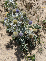
Plants spotted: Eryngium, Eupatorium, Dipsacus.


.jpg)


No comments:
Post a Comment
All comments are moderated. If your comment doesn't appear right away, it was likely accepted. Check back in a day if you asked a question.