Preface ~ The Trip ~ Epilogue ~ Photos
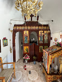
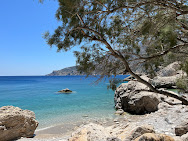
Left: Agios Ioannis path to beach - Karpathos, Greece.
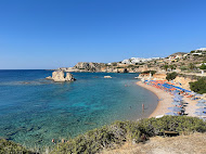
Center: Agrilaopotamos Beach with view of Kasos Island.
Right: Votsalakia Beach, Karpathos Greece
This post is about 3 days we spent on Karpathos. This is not a travel piece to entice you to go to Karpathos. In fact, after reading this you might think twice about going. Most writing you’ll find on Karpathos gushes about visiting this Dodecanese Island. And while it's s special and beautiful place, we won’t gush about it.
We write this to leave a record so that someday we may look back and marvel at how we traveled.
Preface
Looking back, our short stay on Karpathos feels like a hazy hot dream. Temperatures soared on Karpathos while relentless hot winds blew day and night. We were in a hot spell, and it isn’t always like this
we were told.
A fire on the neighboring island of Rhodes caused mass (tourist) evacuations and some concern if the same could happen on Karpathos. News about how hot the world is getting reached us in dribs and drabs on our cell phones as we went in and out of reception driving around the island.
A week earlier we were in Merano, in Northern Italy, and temperatures there were off the charts. We traveled to Merano in a friend’s car. And as it goes with car travel, we felt obliged to take whatever we thought we might need. And one of those items was a fan. Really. And boy did it come in handy in a no-air-conditioned apartment. Air conditioning is generally not needed in Merano
we were told. Maybe that’s about to change.
Back to Karpathos: the world can seem apocalyptic these days, and yet we continue to travel as if nothing is wrong.
As we drove around Karpathos in a rented Suzuki with its squeaking timing belt (because it’s new
we were told) and canvas top flapping in the wind, we cringed at the thought that we were contributing to the climate problem. And as if to remind us, the gas tank assaulted us nonstop with the smell of gas. We joked that it was so hot, the gas was vaporizing.
Even the radio in our rental Suzuki was on the fritz. The plaintive sounds of Greek and Turkish traditional music came and went like gusts of wind.
Koyaanisquatsi could have been the soundtrack of this trip.
There are limited ways to get around Karpathos. Driving is the main option and a choice we rationalized as justified. There were few buses and boats (or any form of public transportation) that we saw and we were out during the weekend and weekday.
The Trip
We promised ourselves earlier in the year that we wouldn’t travel during high season in the summer (roughly July 15 – August 30), and here we are doing it because I friend asked us to come along and we couldn’t say no. Two years ago, we had a longer, calmer, and saner visit to Crete – a neighboring island. We used the car but had many days of no car as well. And, that trip was in September, well after the summer rush. See
12 Days in Create and We Barely Scratched the Surface.
Karpathos (accent on
kar) is the narrow backbone of a mountain that gently rises in the south to steep slopes in the central and north part of the island. The island is at its widest 12 km and at its narrowest 3.5 km. The geography of the island is such that you are driving mostly north-south and occasionally east-west. And while the island is just under 49 km long, it takes time to get around.
The vegetation of Karpathos is Mediterranean maquis, which can be quite pleasant and is one of our favorite biomes. (Doesn’t everyone have a favorite biome?) Some parts of the island are bleak, and seemed even more so in the withering heat. Some parts of the island are not quite but almost lush, those being the sections of forest of Turkish pines (
Pinus brutia). We are sure that if we were to visit Karpathos in Winter or Spring, we might fall in love big time, but not on this summer trip. This time: just a fling.
The average visitor doesn’t go to Karpathos for the biome now do they? No, it’s all about the beaches. And for some folks, the more remote the beach the more cachet it has. That’s where the Suzuki comes in. We were planning to go to beaches on dirt roads and needed the confidence to do so without getting stuck. Just like lemmings.
Some specifics of our trip:
* We arrived on Karpathos from an
AeroItalia, directly from Bergamo. The enticement to visit this island was directly related to the existence of the direct flight.
* We stayed for 3 nights/3 days. In that time, we covered a significant part of the island as shown in a image in this post. We visited over 20 restaurants and points of interest (beaches, cities, landmarks). That was all done by car.
* If you are driving, get the standard tourist map of the island that shows where gas stations are.
* We stayed above Amoopi Bay in a simple apartment. Breakfast was at the pleasant
Skala.
* In terms of a no-car trip there, you can certainly stay in a place like Amoopi Bay or Pigadia and take a taxi from the airport to your hotel. From your hotel, you can walk to beaches or maybe take a bus or boat. (We saw few buses or boats during our stay.)
* The village of Olympos (
Olimpo in Italian) in the north of the island is typically on many visitor checklists. It’s an hour drive from Pigadia on a winding road, which at times is filled with rocks and boulders that fell from above. There are no gas stations along the way. It’s a pretty and desolate drive. We saw one bus arrive at Olympos so there must be options for bus or boat/bus combo to get there. So, you could get there without car.
* Olympos has one main street (a walkway really) that winds up through the town. (There are other small alleyways but are not obvious at first.) The main street is a shopping bazaar of sorts with interesting places to eat along the way. You’ll see
Frida Kahlo’s (Mexican) face staring at you from much of the merchandise of the shops along the way. Um, why? Maybe most tourists think she's Greek?
* Besides the precarious way Olympos sits on a ridge, the next thing you’ll probably notice are the windmills, or better yet what used to be windmills. We couldn’t find much explanation at all about these. To grind wheat we think to make the local
makarounes pasta. But where is the wheat grown? Why aren’t any windmills restored and working? Seems like a lost opportunity to educate visitors. For more information, see
Olympos Windmills.
* Where we stayed in Amoopi Bay it was generally hotter by 5 – 10 degrees Celsius than the other (west) side of the island. Also, be careful of weather predictions as they may be from the airport weather station and that is far south of the island and might not have much to do with temperatures you experience elsewhere on the island.
* During our 3 days we swam 8 times in the ocean, at different points around the island. And while the water was clean – as far as we could tell – it wasn’t exactly chock full of sea life. The best underwater life we saw as at Votsalakia Beach just south of Amoopi Beach. And to see some fish we had to swim out a bit.
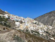
Left: View of Olympos, Karpathos, Greece.
Center: A woman sitting in Olympos - Karpathos, Greece.
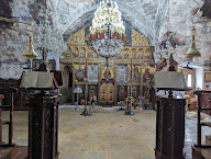
Right: Olympos Cathedral, Karpathos Greece.
Epilogue
We are never sorry to spend time and money travelling. Or if you like, “taking a vacation”. (Consuming and polluting to do so: we are always aware of and try to find the least impactful ways.) We are glad to have had the opportunity to visit the Island of Karpathos. For us, the more interesting question when we travel is if we would we return to a place. The answer in the case of Karpathos is probably no. And that “no” has to do with a few factors:
Unsustainability From the moment we landed to the moment we left, we consumed petroleum in one form or another.
We used gas to fuel our rental car. We used a lot of plastic water bottles because we couldn’t drink from the tap -
we were told. The air conditioner running nonstop in our apartment was likely powered by burning oil. (We did see some wind turbines and solar on Karpathos but not in numbers to make a big difference. See this
report.)
The constant consumption didn't feel good. Sure, next time, don't rent a car, travel around the island less, take a big water bottle and refill it. This would help a little.
We realize that some people might see sitting at the beach under umbrellas as purely relaxing and a necessary recharge from work. We think that idea is somewhat manufactured and at the scale occurring during the summer (European) vacation season, it hardly seems sustainable when you think of resources consumed. (See this article from the NYT, which I found after writing this post:
Is This the End of the Summer Vacation as We Know It?)
The landscape is not well-cared for Unfortunately, a lot of the landscape on Karpathos looks like someone had an idea but didn’t finish it. Half-built houses. Houses with rebar sprouting from the top of them for the
maybe-someday second story. Empty lots filled with debris or building material – as if someone dumped the material after a project or brought it there for a future project.
From a distance, the Karpathos landscape looks magical. Up close, less so. We did see similar "scenery" in other parts of Greece, so it's not just a Karpathos thing. Maybe we need to look carefully or change our idea, but all to often the landscape looked messy.
The only crisp and well-kept areas are those around churches, be they in a town center or in remote locations. An idea entered my mind: maybe all the energy went into maintaining these churches and people got tired after that?
Beachgoer culture = boring for us
We hate sitting at the beach. We are not beachgoers. I know, what are we doing here!?
We do love swimming in the ocean. (And the ocean around Karpathos was clean and we enjoyed it.) We try to go swimming in the morning or late afternoon.
Given the statistics for other Greek islands, we guess that 30 – 50 percent of the visitors to Karpathos are Italian. Also, many wait staff had a pretty good command of Italian, which leads us to believe they are often serving Italians. In fact, this vacation felt like it could have been in Italy. That's all to say that Italians love to park themselves at the beach. Italians are beachgoers in spades. See
Abbronzatissima: Notes on the Allure of the Suntan in Italy.

 Left: A bus stop in Lefkos, Karpathos, Greece.
Center: Vananta Ag Anargiroi - Karpathos, Greece.
Right: Karpathos locations visited during 3 days in July 2023.

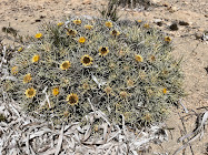 Left: Salt cedar (Tamarix) at Agios Ioannis Beach.
Center: Echinops spinosissimus - Karpathos, Greece.
Right: Carlina tragacanthifolia - Karpathos, Greece.


Left: Makarounes in Agios Nikolaos, Karpathos Greece.
Center: Breakfast yogurt and coffee at Skala, Lakki, Greece.
Right: Appetizer at Finiki Mama Cusine, Karpathos, Greece.







.JPG)



![[Boraginaceae] Echium vulgare – Viper's bugloss [Boraginaceae] Echium vulgare – Viper's bugloss](https://blogger.googleusercontent.com/img/b/R29vZ2xl/AVvXsEg6M8-BA3MqHZrBXBq9ZSKyJy7AKXMkwHSCuTAiaNLRrXZFjCZVReSnpLfeNhhlGZ_Mgf62z3WbHJu3-Hjt0jbZvvpBcW0DROyoVw5HqIyUZFjzgzrjP_lI3kGsyImZjwcHjIEF20W50gfzvvVA0WlyDyNylGFcnS5DzVNGViHN21jJbApWNWelhQ3YhQ/w240-h320/%5BBoraginaceae%5D%20Echium%20vulgare.JPG)
![[Caryophyllaceae] Silene flos-cuculi – Ragged-robin [Caryophyllaceae] Silene flos-cuculi – Ragged-robin](https://blogger.googleusercontent.com/img/b/R29vZ2xl/AVvXsEg32lLpJXvPwlSQIcFUZlWSWR774uHyrulm1kv460_SmMdhT_Zn_ZNQ7chPnAArobI-AwXG70gGLwY6h-XL21z9Z6RMktoD2bERMCTEFkDzDmQrhtnNFkbMc6JDfRKTaYKBMP4Y9BIaqN9UfD1ZbtcA4_FFICG2Ecvxx5Zgbb0wy2p-KJQI_DSPzCsU8g/w240-h320/%5BCaryophyllaceae%5D%20Silene%20flos-cuculi.JPG)
![[Convolvulaceae] Convolvulus arvensis – Field bindweed [Convolvulaceae] Convolvulus arvensis – Field bindweed](https://blogger.googleusercontent.com/img/b/R29vZ2xl/AVvXsEgdgXUgaHEiT9pNu_qxib2ZjxVjJvqiAcD4txfticXfZcXklgMaPgxwtK-xcZvtrTmBPJKa2CThN78thh-NjP7PtLCdLcRnoNuBh3oxtJW-mAgiiEPXAleVIraBwFDZdp9yzzqB2datEghTzLx1vJONDfrmxeKHLiwqZfgjceAbDijwS1po0pJ-cTLM3g/w240-h320/%5BConvolvulaceae%5D%20Convolvulus%20arvensis.JPG)
![[Crassulaceae] Sedum acre – Goldmoss stonecrop [Crassulaceae] Sedum acre – Goldmoss stonecrop](https://blogger.googleusercontent.com/img/b/R29vZ2xl/AVvXsEg3PdLVdRFqo6SF3FaXntGuizoYfMmjLMnx1fyAMkRA9_kTn8wH-rw3CssV-9M9_XIbQWQAAT294cksZLnpHhgMmlDxnUtSKAwdWVsKDWy7uhd2mtdnieUF6FbqHXV-VDr-iKc2HAXIHBu8iKyq9H_QyHoQwfoJCkkHz1W3R4HW7g2llTs372d75r5b0w/w240-h320/%5BCrassulaceae%5D%20Sedum%20acre.JPG)
![[Fabaceae] Ononis spinosa – Spiny restharrow [Fabaceae] Ononis spinosa – Spiny restharrow](https://blogger.googleusercontent.com/img/b/R29vZ2xl/AVvXsEg_ZAqwJMyIO5SGXLlcL7ffSF0OZxvRxjNBZ37hnpt94hx8xhy-T6UmeAY5eOTPnZVWFRo60iFw6JIbpDS_ArxF4iQpEKLhrm6m96VdMRoGTPY1wX4ac--DRfeWsI7ClqBP8crvfWE1zKEu2OhA5z9ve4nbbpMjUwX5MBSiBWim6IzUCl5eYarHe9ZJtw/w240-h320/%5BFabaceae%5D%20Ononis%20spinosa.JPG)
![[Hypericaceae] Hypericum perforatum – St. John’s wort [Hypericaceae] Hypericum perforatum – St. John’s wort](https://blogger.googleusercontent.com/img/b/R29vZ2xl/AVvXsEjBznY03vlpdsp2xsqNY4LIJzdE6dEUDPD-FUVzALn7YkDmPAODbPvXVJwEM6vegyHGMWtWMn0EKU5jMMXSuotFHi3ghdsZFCwQDxRIwcJVCn4SqUPWjNnCrs5mb6Rcw0-gyUOyqvj7-bgVnxVTmqBhAQX_GY0dqGMzZzvUMzFNeYaFuxb5vcIa5xJQeA/w240-h320/%5BHypericaceae%5D%20Hypericum%20perforatum.JPG)
![[Lamiaceae] Prunella laciniata – Cutleaf selfheal [Lamiaceae] Prunella laciniata – Cutleaf selfheal](https://blogger.googleusercontent.com/img/b/R29vZ2xl/AVvXsEibcEB19P2Zka_T14Whuy7cJ7I0Ks5Ux0zQWa6AuSGKN4WaXVWCC_rHso4Lbvg1AObDgRho_cxD8nxXjuZNEBeSJnP1a1fHK0ZM7u9l_TTeWMpMtxiC-CO6ncg7xT_sm6dP0-y1vn729aBruEtumXB2KrAiZN4W_g2bWRh_9_1nmUjENQl6kmlFG7LVDQ/w240-h320/%5BLamiaceae%5D%20Prunella%20laciniata.JPG)
![[Rosaceae] Rosa arvensis – White-flowering trailing rose [Rosaceae] Rosa arvensis – White-flowering trailing rose](https://blogger.googleusercontent.com/img/b/R29vZ2xl/AVvXsEjfp_z5YzOeDnGZ0wJd7Xf-vIcfQqwb0_FhYGqrSU7eE31lwz874O-olWeJr8Ro8Ht-I2BGD5yPQwCntTmSCFuKo8-X2333sT1_STfmIRU3LPeEUc8yS7cH3OYAc2jVaUvw3phlSXQE_dh5pbqlcdNsiJANmzpyKjFQTgIYcCcinXwQpJFRIpjiXwWeuA/w240-h320/%5BRosaceae%5D%20Rosa%20arvensis.JPG)
![[Malvaceae] Malva moschata – Musk mallow [Malvaceae] Malva moschata – Musk mallow](https://blogger.googleusercontent.com/img/b/R29vZ2xl/AVvXsEjYyXyrjFrjrVaRwcMiaIkzhSc9xtHGmZjmSZpsGCVuJGONzSzhsTc7BKXYkrcxZ02BnPflwQVgorn-DP17S2YbS8wGzOLVc4BFkWJ0_yZ82SV2eZwPcubtDYc4_Px4j3xYOwP2DI2MEfMPnDix2ahkSLVLMGbkMec5RTFM06jeeeSOsOkb60S7Nzb-Aw/w240-h320/%5BMalvaceae%5D%20Malva%20moschata%201.JPG)
![[Malvaceae] Malva moschata – Musk mallow [Malvaceae] Malva moschata – Musk mallow](https://blogger.googleusercontent.com/img/b/R29vZ2xl/AVvXsEiNpwZ9ava8B4BYrK40F4m6-prp21kBm0Lo5w6iC4hr0LBHhWHc-zOdmvoo6WteeW4KuX1zpAgwjSocBcPQxNLSBv0xLFPm53uvQOvJkoUonP6ki3o50ijKG1qiOuJa_yiB9676fS8U2C3T7iz-gmMfeqDtz3RX4EvuVPymzNAiIhpka8DCUePL_MGNNA/w240-h320/%5BMalvaceae%5D%20Malva%20moschata%202.JPG)
![[Orchidaceae] Anacamptis pyramidalis – Pyramidal orchid [Orchidaceae] Anacamptis pyramidalis – Pyramidal orchid](https://blogger.googleusercontent.com/img/b/R29vZ2xl/AVvXsEge_tz7yhxgj2uKmxtCrWXyd62Jj6eoll202X7_keObuswAek_Wn01Zqov4napYFJs67unEd--j0nBaFEXTg3bMZiO_keREA1FJRrg38hSOGFPCNl9teGQ_Kdr6WDpehXgfzlhxZhH-_NzGbmAPO47cfeQ2hn_QktaD0RdAdcVGCTgVbQiaWQXWIWzYvw/w315-h237/%5BOrchidaceae%5D%20Anacamptis%20pyramidalis%201.jpg)


![[Orobanchaceae] Orobanche rapum-genistae – Broomrape [Orobanchaceae] Orobanche rapum-genistae – Broomrape](https://blogger.googleusercontent.com/img/b/R29vZ2xl/AVvXsEibybc4GoA5zq1rACtamlEupyi5L1TU8sdtkOdp2b3XDFqwDdSktcNLNV1QViaHQXGXPAxZs4fqlWz_nikx28pjVftVFlzEyfTCFO2tT5yBvNkWscLSd-wBIEYCwTbf705l6Q6F1xCokOTLusyqr8qCUViu_eJ_-8G4H51F-fxdBchTkFR7krbSjCYQ6g/w240-h320/%5BOrobanchaceae%5D%20Orobanche%20rapum-genistae.JPG)
![[Ranunculaceae] Helleborus foetidus– Stinking Helleborus [Ranunculaceae] Helleborus foetidus– Stinking Helleborus](https://blogger.googleusercontent.com/img/b/R29vZ2xl/AVvXsEjO4sANMfkl8L21aj8EY-9jBPWvSzOJAfBrTL3fFvD7OJeZWIm8tV5hkb_RKrDu_0PZvWzvL2Gx4yEPZbqz8NAiF90x4Nl37yuCc1b1yuJXLVRw_xEOkjIcshtZBeTzZhHtCFN5Laa7_BnW9CcQqq0qhDUAvkqMIOvXviA78wgD_4675sfmod3MVoW1vA/w240-h320/%5BRanunculaceae%5D%20Helleborus%20foetidus.JPG)


