


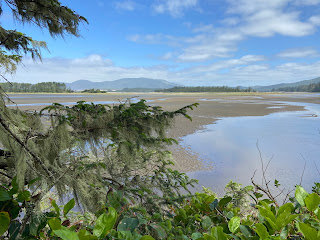

Scenes around Pacific City, Oregon.
Overview
In this post, we are at the edge of the Pacific Northwest, on the coastal dunes of Pacific City, Oregon. If our Henry Island trip was about the "boating life", this trip is all about the "beach life". The only time we'll get in the water on this time is to let the waves wash over our feet on long walks agate hunting. The sea is ever present but we are always on the edge of it, exploring it "littorally".
Dunes and capes
Our first order of business after arriving at our friends' home is to climb a huge grassy dune and get our first look at the ocean and Haystack Rock. This sea stack orients you along the coast. Even after just one day, as we travel up and down the coast, we find ourselves instinctively looking to see where we are relative to Haystack Rock.
We climb over the grassy dune courtesy of an impressive wooden dune ramp. This dune is a "back dune" that rises high above the houses protected behind it to the east. Dune grass, Ammophila breviligulata, helps stabilize the dune. Other communities along the beach that removed their back dune did not and do not fare well from the constant winds and shifting sand as they take the direct impact of storms. A view of the ocean comes at a price.
The dune ramp brings us up to a high point of only 56 feet but that's plenty for a 360 degree vista. The Pacific Ocean and Haystack Rock are in front of us to the west. Coastal, temperate rainforest is behind us to the west. Slip sliding down the beach side of the dune brings us to a wide beach running north – south. We are between Cape Kiwanda State Natural Area to the north and Bob Straub State Park to the south. We are oriented.
There are three Haystack Rocks on the Oregon coast. From north to south, there's Haystack Rock at Cannon Beach (Clatsop County), Haystack Rock in Pacific City (Tillamook County) discussed in this post, and Haystack Rock at Bandon Beach (Coos Bay). The Pacific City Haystack is a sea stack about a half mile offshore. According to Oregon Coast Beach Connection, Haystack Rock was once connected to the adjacent Cape Kiwanda. And, Haystack Rock being made of basalt helps protect the cape from erosion.
Cape Kiwanda's bluffs and sand dunes immediately catch your imagination. The name of the cape is said to be a variation of an Indian chief's name Kiawanda. In fact, many names in this area – Kiwanda, Nestucca, Tillamook, and Neskowin just to name a few – stir in us a desire for a deeper understanding of the tribal history of the Native American peoples of Oregon, and the what and why behind the place names.


Cape Kiwanda Dune.
In contrast to Haystack Rock's inaccessibility (except to seabirds), the dunes of Cape Kiwanda are very accessible. To climb the dune – two steps forward and one step back – with your feet in the warm sand is an unusual sensory experience. Many of us don't see this expanse of sand, so broad and high. Even more surprising on our first time up the south side of the dune is that just before cresting the top, we see large colored fabrics appearing, fluttering, and then disappearing. It seems impossible and disorienting. What could they be? When we reach the top, the mystery is solved. We are seeing the wings of the paragliders launching, landing, and otherwise skimming off the north side of the dune. A paraglider passes several feet in front of us "walking" his paraglider to a point he'll launch from. His dog follows him, barking happily. As soon as the paraglider launches, the dog runs back down the dune as if it instinctively knows where its owner will land.


Paragliders on the Cape Kiwanda Dune.
We are about 120 feet high on the dune's ridge, which separates Pacific City Beach to the south and Cape Kiwanda Beach to the north. From the top, you can look farther north up the coast to Tierra del Mar and further south down the coast to Neskowin. Descending the north side of the Cape Kiwanda dune, we reach the tide pools of Cape Kiwanda.
Today is calm and the tide low enough that we can explore the tide pools. We become kids again exploring in water up to our knees. Carrying our sandals, we step gingerly around colonies of aggregating anemones (Anthopleura elegantissima) and fluorescent giant green anemones (Anthopleura xanthogrammica). Crabs hide on boulders coated with pelagic goose barnacles (Lepas anatifera) and California mussels (Mytilis californianus). Once the crabs stop for a moment, good luck trying to find them again. The Cape Kiwanda tide pools are one of many along the Oregon Coast.


Photos of Cape Kiwanda Tide Pools.
Ghost forest
One cool Saturday morning, we roll into the Neskowin Farmers Market in Neskowin, a town just south of Pacific City. The market esthetic is low key, northwest hip. A dusty Tesla rolls into the parking area, its gullwing doors lift, and a man exits with knee-length dreads. A sign high in a nearby alder tree looks like a red and white traffic sign but instead has the inspirational message "You are enough". Berries, cheeses, and bread are on our shopping list today and we find them and more. A guitar player strums and sings a soothing mix of blues and folk. We eat pizzas fresh out of an wood-fired oven and listen. At this moment: this is enough.


Scenes from the Neskowin Farmers Market including jams by Gingifer's Kitchen and morels.
After the market, we head over to Neskowin's wide beach fronted by Proposal Rock. The "rock" is actually a sea stack like Haystack Rock of Pacific City, except much closer to shore. Proposal Rock is a lushly wooded hill, like a piece of the mainland forest that floated away.
A beach, a creek, and the sea border Proposal Rock. Only in the Northwest can you find this geography and beauty. And only in the Northwest can you find families enjoying the beach on a gray misty day. (In Italy, this we would never be seen!) Families build little encampments of chairs and blankets, dug in for a day at the beach. The beach is large enough that it never feels crowded. Kids run and play in the shallow Neskowin Creek skirting Proposal Rock and emptying into the surf. The more adventurous kids cross the stream and climb up and disappear into the green of the rock.
A typical day during our time Pacific City starts by reviewing weather predictions and tide charts. We are in luck today because the tides are low and we are treated to a glimpse of the Neskowin Ghost Forest, just south of Proposal Rock. The Neskowin Ghost Forest is one of many ghost forests typical of coastal regions where rising sea levels or tectonic shifts alter land masses.
The scientific explanation of the Neskowin Ghost Forest is still an open question. The leading explanation is that these stumps – remnants of a Sitka Spruce forest – were created when an earthquake of the Cascadia Subduction Zone abruptly lowered the trees. Subsequent mud from landslides or debris from a tsunami covered the stumps, many of which are estimated to be over 2,000 years old. The paper Episodically buried forests in the Oregon surf zone has graphics of what the tree stumps look like below the surface, which includes remnants of forest soil.
However the trees ended up in the surf, it's an eerie sight. Barnacles coat some of the stumps rendering them as like giant mushrooms emerging from the surf. Other stumps contain mini-tide pools full of creatures echoing what we saw days earlier in the Cape Kiwanda tide pools.

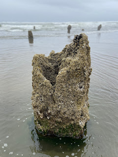


Photos of the Neskowin Ghost Forest.
World of salt
Later in our Neskowin Farmers Market day, we drive north to visit Nevør Shellfish Farm and Jacobsen Salt Co. At Nevør, Pacific oysters (Magallena gigas), an introduced species from Japan, are on the menu. The Pacific oyster was imported in the 1930s to save the West Coast oyster industry after the native Olympia oyster (Ostrea lurida) was nearly wiped out. The Pacific oyster is the main oyster used today worldwide, from France to China.
The different types of Pacific oysters can be chalked up to cultivation and merroir – terroir for oysters. At Nevør the oysters we buy are named Petite Tørkes and reflect merroir of the Netarts Bay where they are cultivated. The Oysterater site says of oysters, "[t]hey are as close as you can come to eating the sea and getting away with it" and in this case we are eating the sea of the bay we glimpse through the trees as we snack on barbequed oysters, sitting at a picnic table.
If oysters are a metaphorical sip of the sea, then Jacobsen salts are a sprinkle of the sea on your food. Water from Netarts Bay is a good starting point for making salt because of the filtering effect of nearby oyster cultivation like Nevør Shellfish Farm and Netarts Bay Shellfish. Another reason the bay yields good salt is because there are few freshwater sources coming into it, leading to less possible contaminants. The water from Netarts Bay goes through three stages to become salt: a reverse osmosis machine converting seawater to prebrine, a boiling process converting prebrine to brine, and an evaporation process converting brine to final product.
A few days later, we make peanut butter cookies, dip them in chocolate, and finish them with a sprinkle of Jacobsen salt. Netarts Bay for dessert.


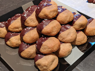
Left: Barbequed oysters at Nevør. Center left: The menu at Nevør. Center: Shucked Nevør Petite Tørkes oysters. Center right: Boiling tanks at Jacobsen Salt Co. Right: Jacobsen Salt Company flake salt on peanut butter cookies.
Sedges have edges
During our time in Pacific City, we also visit Sitka Sedge Natural Area, an estuary and large beach. Our very first question after stepping out of the car: is this really named after a sedge? The answer is yes! The area is named after Water Sedge or Leafy Tussock Sedge, Carex aquatilis, which grows natively in the natural area. In Pacific City, we also spot Large Headed Sedge (Carex macrocephala) mixed in with dune grass.
All this talk of sedges recalls the gardening rhyme: "Sedges have edges, rushes are round, grasses have knees that bend to the ground". We use this rhyme to explain the difference between the different species: Cyperaceae, Juncaceae, and Poaceae, respectively. Our friends have never heard the rhyme and tease us but won't soon forget the difference. To clarify: the knees of grass are "joint-like nodes found along round, hollow stems. The stems of sedges and rushes are solid; in cross-section the stems of rushes are round, while those of sedges are triangular and so have edges."
At Sitka Sedge, we start in a parking lot just off the road and walk along a trail with Sand Lake on our right and Reneke Creek and marsh area to our left. Where there are wooded areas we are under Sitka spruce (Picea sitchensis) with Salmonberry (Rubus spectabilis), Swordfern (Polystichum munitum), and Treacleberry (Maianthemum racemosum) as groundcover. When we are in full sun, we are shoulder to shoulder with thickets of Rose spirea (Spirea douglasii), Twinberry (Lonicera involucrata), Red Elderberry (Sambucus racemosa), and native roses. As we near the beach, the ground becomes sandy and it's Shore Pine (Pinus contorta) and Kinnikinnick (Arctostaphylos uva-ursi).
Anoher afternoon in Pacific City, instead of walking up to the dune to the sea, we instead head inland on foot to a wooded forest. We walk into a temperate coastal rain forest. On our way up the small hill, we encounter a mother deer with fawn. We crouch, and the doe and fawn pick their way around us, walking through stands of Tall Scouring-rush (Equisetum hyemale). The gardening rhyme needs an addition for horsetails: "Sedges have edges, rushes are round, grasses have knees that bend to the ground, and horsetails nobody wants around"?
After a short climb we are at an observation point, about 262 feet above sea level, in a sliver of the Siuslaw National Forest. A clearing through the trees reveals a perfectly framed Haystack Rock, our orientation point.
A rundown of other plants we encountered during our stay in Pacific City, ordered by family, include:
Adoxaceae - Sambucus racemosa - "Red Elderberry"
Asparagaceae - Maianthemum dilatatum – "Snakeberry", "Two-leaved Solomon's Seal"
Asteraceae - Tanacetum camphoratum - "Dune tansy"
Asteraceae - Achillea millefolium - "Yarrow"
Brassicaceae - Cakile maritima – "Sea rocket"
Convolvulaceae - Ipomoea pes-caprae - "Beach morning glory"
Fabaceae – Lathyrus japanicus – "Beach Pea"
Fabaceae - Lupine littoralis - "Seashore lupine"
Melanthiaceae - Trillium ovatum - "Western trillium"
Nyctaginaceae - Abronia latifolia - "Yellow sandverbena"
Orchidaceae – Goodyera oblongifolia – "Westerna Rattlesnake Plantain"
Pinaceae - Pinus contorta - "Beach pine", "Shore pine"


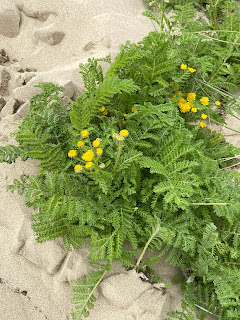


Photos of plants observed in and round Pacific City, Oregon.
Chance upon a dory
Reviewing our photos of our time in Pacific City, we find many show wet sand creating a warbled mirror of the sky and objects in the horizon, be they Cape Kiwanda or Proposal Rock. (Reflective beach has an entirely different meaning as described here.) The effect reminds of us our Northwest hikes and the reflectivity in alpine lakes. 


Beach reflections in Pacific City, Neskowin, and Tierra Del Mar Oregon.
On the south, protected side of Cape Kiwanda, the wet sand mirrors the cape and its dunes. The placid mirrors are interrupted every so often by a dory charging into shore. Keep your wits about you in this area. If you hear an air horn, it means a dory is incoming. Get out of the way.
The dory pilots must land their boats on the sand by sliding up on to the beach. To do that, they gun the engines while still in the surf, blowing the horns to scatter surfers and warn people on the beach. At some point close to shore, the engines are cut, and the boats glide up the beach. The sand is the brake.
Pacific City dories have a unique history in this area with no dock, port or marina. It's one of the few places in the world where the beach is used to launch and land boats. The dory's flat bottom is the key. For more information, see this Oregon Field Guide video: Dory Builder.
One evening we play Farkle and Golf, games of chance. We pick the player names: Circuit and Phantom Music. Our friends choose: Kwazimabababa and Design Schlong. Life is about chance. Chance encounters years earlier result in us playing Farkle and Golf with Kwazimabababa and Design Schlong on the Oregon Coast.
Since 1854, there have been 21 tsunamis that have reached the Oregon coast. Staying in Pacific City, we couldn't help but notice tsunami evacuation maps, signs, and sirens. Upon arriving, Kwazimbababa and Design Schlong, like seasoned flight attendants, inform us of our evacuation route, pointing our way to higher ground. Such wonderful and knowledgeable hosts!
Tsunamis are most commonly caused by large earthquakes under the ocean, such as ones from the Cascadia Subduction Zone, which lies about 70 – 100 miles off shore. An earthquake in this fault is why the Neskowin Ghost Forest pokes out of the surf today and not soil.
There are two types of tsunamis, distant and local. Distant tsunamis will generally cause warning systems to go off and you'll have time (up to hours) to evacuate. With local tsunamis such as from the Cascadia fault: the earthquake may be your only warning. In this case, after riding out the quake (drop, cover, hold on), immediately head to higher ground. Don't leave it to chance.
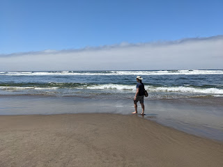


Left: Walking on the beach near Pacific City Oregon, what you shouldn't do after an earthquake or after hearing a tsunami warning. Center left: A tsunami evacuation plan in Neskowin. Center: Informational sign describing the history of the Pacific City dory. Center right: A sign showing sea life to be spotted at Cape Kiwanda. Right: Map of Sitka Sedge Natural Area.
Coda: song to a siren
In Pacific City, we wandered between dunes and forest, tasted and felt salt and sand, looked for agates and ghost trees in the surf, and silently wondered about our future. A question we heard many times rattles around in our heads: "What are your plans?".
Climbing the Cape Kiwanda sand dunes one cloudless day, we inch our way to the top, stopping every few feet to rest. We can't decide whether to go barefoot to sink deep in the hot sand or wear sandals to avoid the heat. Sandals go on and come off several times. We are with friends and the talk turns to uncertainty and future plans. They too – we discover – are often asked about their plans and they don't know either. It is not unique to us. Collectively, we arrive at a realization that it's okay to say "We don't know". We sail on a journey with no particular destination.
Long afloat on shipless oceans
I did all my best to smile
'til your singing eyes and fingers
Drew me loving to your isle.
And you sang
Sail to me,
Sail to me, let me enfold you


Great article. We were there 4 days. Amazing place!
ReplyDelete