

Length: ~ 18 km
Duration: ~ 4 hours walking, plus 1.5 hours for lunch.
Elevation: Almenno San Salvatore starting elevation: 328m; Monte Linzone ending elevation: 1392m. 1064m gain.
Location: Valle Imagna, Province of Bergamo, Italy
We just finished up our test d’ingressso - entrance exam – for determining our Italian level for the University of Bergamo CIS – Italian for Foreigners and we needed to unwind from days of
From the Bergamo train station, we took a bus (see arriva.it) from Bergamo to Almenno San Salvatore. We exited the bus and started hiking at 11:30. We broke for lunch around 13:00 at the restaurant Belvedere (via San Bernardo 7) in Roncola. With full bellies, we started walking again around 15:00 and reached Monte Linzone within 45 minutes. We ended back at Almenno San Salvatore at 18:45.
Belvedere in Roncola is a restaurant that can seat hundreds, but today, off season, it’s just us and a couple of locals eating in the small bar area. As we are chatting with the owner, he uses per quello several times reminding me of one of the questions I missed on the exam that required the correct preposition before quello. Too bad we hadn’t done the hike before the exam.
If you are just interested in the view from Monte Linzone, you can start in Roncola. We opted for more of a workout by starting in Almenno San Salvatore and following the first part of sentiero 571. The trail takes you along the ridge between Val San Martino (to the south) and Valle Imagna (to the north), through Roncola and on to Monte Linzone. Of course, 571 continues on much further.
Left: Primula vulgaris [Primulaceae] – yellow and Hepatica nobilis [Ranunculaceae] - purple. Right: Bellis.


Helleborus foetidus along sentiero 571.


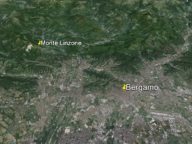
Left: Relation of Monte Linzone to Bergamo. Right: Near the part of the sentiero 571 called Corno Rocchetto with Bergamo in the distant background.


Left: A plate of pasta in Roncola at Belvedere; Right: The trail above Roncola and a paragliding launch site.


Views of trail 571.


Left: View toward Monte Linzone. Right: View back over the Po River Valley toward the southwest. A glider climbing on the currents.


View from the flanks of Monte Linzone toward Resegnone.

Signage for 517, Sentiero Alto di Valle with elevations.


No comments:
Post a Comment
All comments are moderated. If your comment doesn't appear right away, it was likely accepted. Check back in a day if you asked a question.